Maynard House [Column_Cisco Townsite]
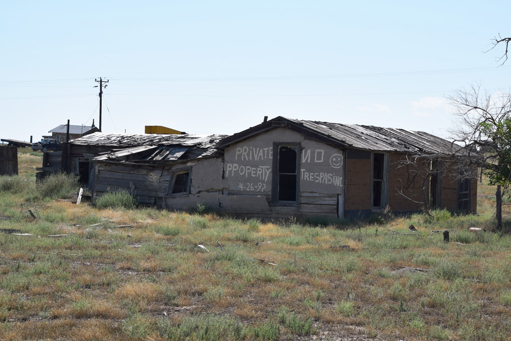 : looking from northwest
 : looking from southeast
I’m trying to duplicate the whole town of Cisco, Utah in N scale. This post introduces one of the structures in the town.
A few businesses survived along US Hwy 50 & 6 at Cisco in the early 70s; 4 gas service stations, a mercantile/cafe, and a motel. Some private houses also seem to exist along Second Street. Between Duke's Service and Ruth 66 Cafe sat this structure at Lot 22, Block 7, Cisco Townsite.
This structure is probably the oldest existing structure in Cisco. The structure is barely seen in the 1944 USGS aerial photo. The same structure is verified as the "Meeker log cabin" in a map representing Cisco in the late 40s[1].
The structure was originally built by Victor Putman Hanson(1841 – 1920) who established the Cisco Townsite, Cisco Hotel, and other principal facilities of the town[2]. According to Vonna Lucinda Foy Dalton(1921 – 2016), part of it had been an original schoolhouse retired in 1919[3].
It was used as the winter headquarters of Fitzpatrick Brothers, a ranch operated by James Henry(1880 – 1928) and William Thomas(1887 – 1933) Fitzpatrick of Montrose, CO. at least in 1923[2]. They were raising sheep in the region.
Ralph Dalton(1916 – 2002) and his family rented and lived in this structure between 1938 and 1944[3, 4].
Frank Meaker(1884 – 1972) of Montrose, CO. owned the lot at least from 1944[5]. He was raising sheep in the region. Elton Richard Cowger(1915 – 1984) and his family who came to Cisco that year rented and lived in this structure until 1950[6].
John Aubrey Maynard(1895 – 1972) succeeded the property in 1959[7]. Aubrey was a sheepman and also a D&RGW hand treating water here[1, 8].
John's niece Sandra and Jay A. Williams keep the house to this day[9].
The structure exists in a rather obsolete style, as you can see above. I used Google Maps to infer the dimensions of the structure to draw plans. The result is shown below; of course, some imaginations are included.
All photos were taken on Sep. 11, 2014
revised, Feb. 4, 2016
revised, Jan. 26, 2017
revised, Jan. 29, 2018
revised, Apr. 14, 2023
[1] Hepperle, Mary L. Cowger. "Memories of Cisco", Canyon Legacy, Vol. 51, Moab Museum, 2004
[2] May 3, 1923 Times Independent
[3] Dalton, Vonna Foy. “Some Remembrances of Picture Gallery and Cisco”, #51, Canyon Regacy, Moab Museum, 2004;
[4] Mar. 2, 1944 Times Independent;
[5] Dec. 7, 1944 Times Independent;
[6] Hepperle, Mary L., (2004) "Memories of Cisco", Canyon Legacy, vol. 51, Moab Museum;
[7] Dec. 17, 1959 Times Independent;
[8] Oct. 31, 1940 Times Independent;
[9] Williams, Sandra (2013) "Notes", J Aubrey Maynard, Find a Grave;
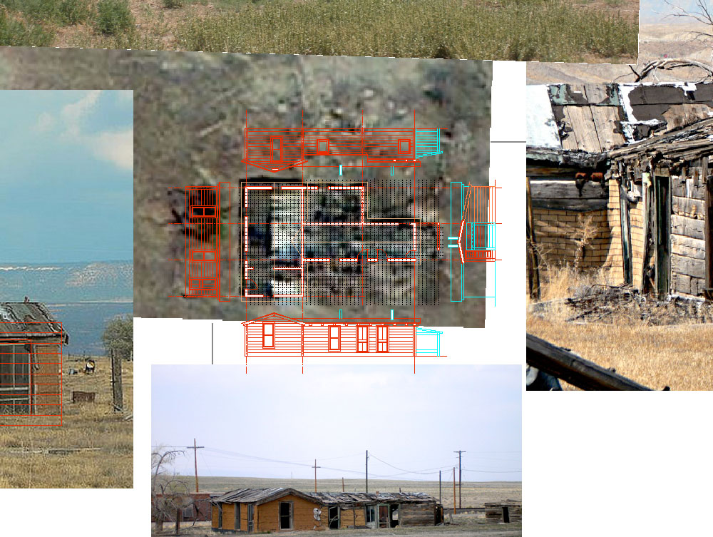 : references and the drawings of Maynard House
 : north, west and south elevation of Maynard House
ユタ州を走るD&RGWの沿線にある/あった、Ciscoという町を紹介している。この建物はCapansky’s StationとRuth’s Cafeの間に建っていた「Maynard House」である。Google mapのstreet viewで見るように、現在も建物はかろうじて建っている。
滞納固定資産税リストによれば、この家は1950年代末からJohn Aubrey Maynardという人のものになっている。ウェブにあるこの人の追悼ページには、姪にあたる人が「We keep your place in Cisco, Utah. You are not forgotten」と2013年に記帳している。したがって、Maynard氏の家とみなして間違いないだろう。
建物は、角材(以前紹介したTie House同様古枕木かもしれない)を積み上げた壁に防水紙を葺いた切り妻屋根を載せた平屋である。ウェブに多くある現況を示す画像では、壁の一部は左官や防水紙で仕上げたように見える。全体の大きさはGoogle mapの航空写真を参考に割り出し、立面は画像を参考に復元した。
2015-03-20 09:00
コメント(0)
arx_Ph.D. さん
Here represented are my model railroad enthusiasm generated from the photos I took during my childhood at Knoxville, Tennessee, or from the photos I took during my recent trips.
I'm a retired professor of design, meanwhile a part-time associate at the architectural design office in Osaka, Japan where I live with my wife.


コメント 0