Water Supply at Cisco, Part 2 [Column_Cisco Range]
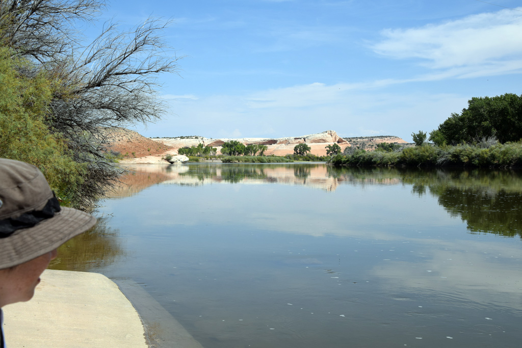 : Colorado River at Cisco Landing
Residents of Cisco practically relied their water supply on Denver & Rio Grande Western Railroad[1]. The railroad supplied the water since the establishment of the town and to the 50s.
The source of the culinary water was the Colorado River about four miles east of the town. The epic water supply system named “Cisco Pipe Line” installed by the railroad in 1883 is well represented in the ICC Valuation Map drawn in 1919 and revised in 1927[2]. According to the Map, Pump H’se No. 25, Coal H’se No. 28, Pumper’s Dwg No. 26 and W.C. No.27 at Cisco Landing, two concrete reservoirs on the hill, a water tank at Cisco, and the 6" steel pipe connecting the facilities formed the system.
Successive operators and sometimes his family resided by the pump house. Found in the Census and newspapers are:
Charles Edward Johns(1855 – 1931) in 1900. Charles U. Hallett(1881 – 1942), Edward K. Holbrook(1854 – ?), and Samuel S. Roberts(1859 – 1930) in 1905. Edward Daniel Stone(1866 – ?) in 1907. Walter Scott Dayton(1874 – ?) in 1910. Henry Hansen(1860 – 1932) in 1913. Perl Claud in 1914. Martin Tifus in 1917. John Callahan and Joseph Killian in 1920. R. Wissler and Frank Hall in 1921. Neil Maurice Carswell(1902 - 1966), and Louis H. Redmon in 1932. Roscoe Clarence Hallett(1890 – ?) in 1940.
Albert J. May(1890 – 1973) of Green River used to take care of water systems at Cisco, Thompson, Green River, and Cedar before his retirement in 1960[3].
A few ranchers/farmers such as the Augusta Devine family and Ernest E. Campbell family along the Colorado River were their neighbors[4]. A schoolhouse was built at Campbell Ranch[5].
Unfortunately, however, the railroad abandoned the system in 1955[6]. The steel water tank at Cisco was removed in September 1958, along with the tank at Thompson[7, 8, 9]. Pumper’s Dwg No. 26 and W.C. No.27 at the south of Pump H’se No. 25 were retired in preceding 1939 according to ICC Valuation Map. Pump H’se No. 25 itself was demolished in the 60s. The rest is left in the terrain. Here are the photos of the remainder:
All photos were taken on Sep. 10, 2017, except for special remarks.
Pump House [1st]
 : BLM historical marker
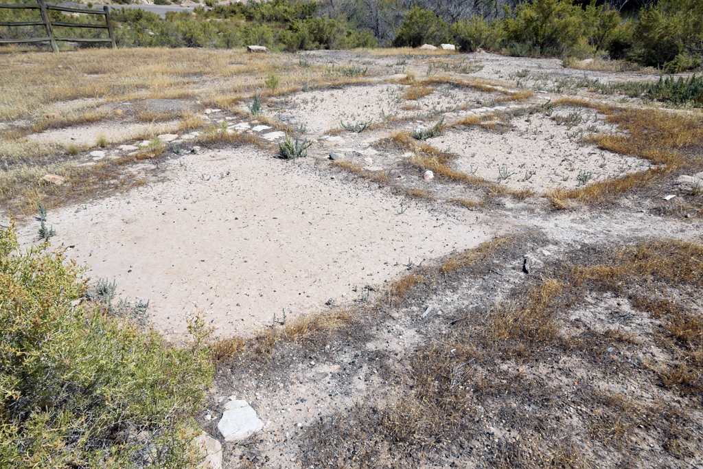 : foundation of a structure
 : 1952 USGS aerial photo of the site
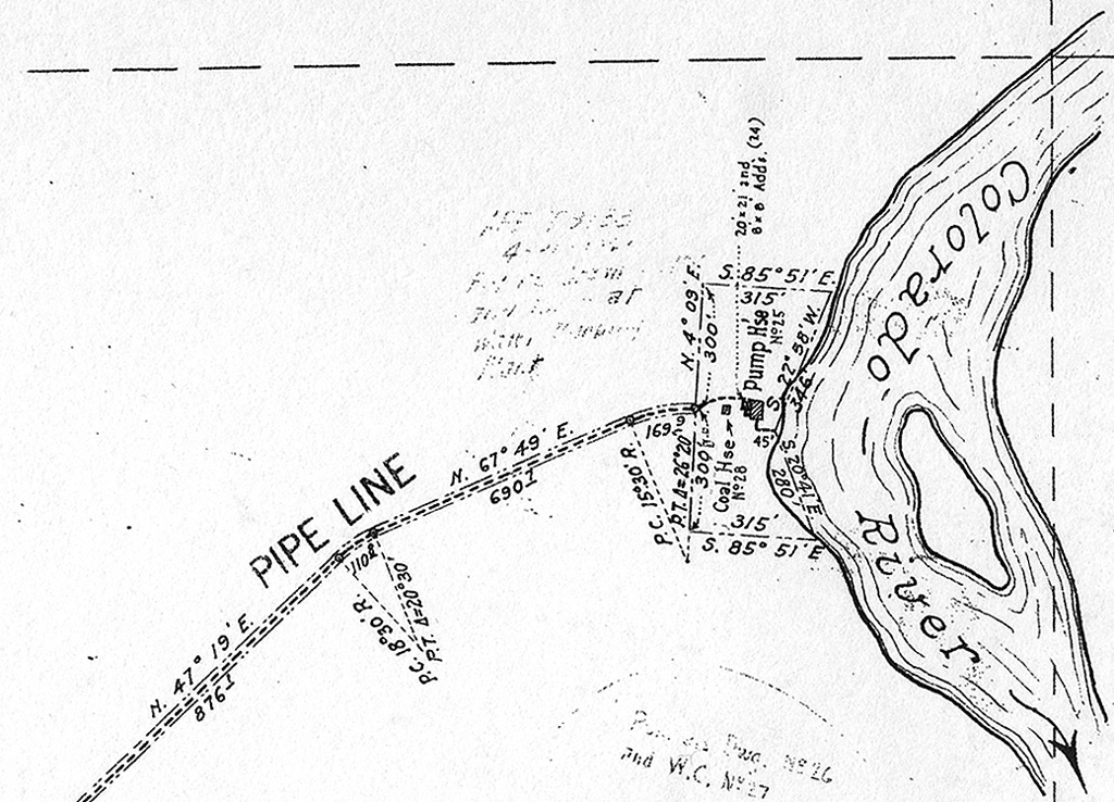 : 1919 ICC Valuation Map
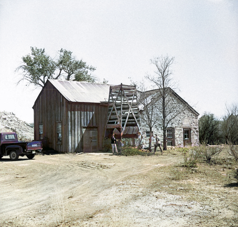 : May 1,1960 photo by Jim Ozment
 : pump house interior at Gato[10]
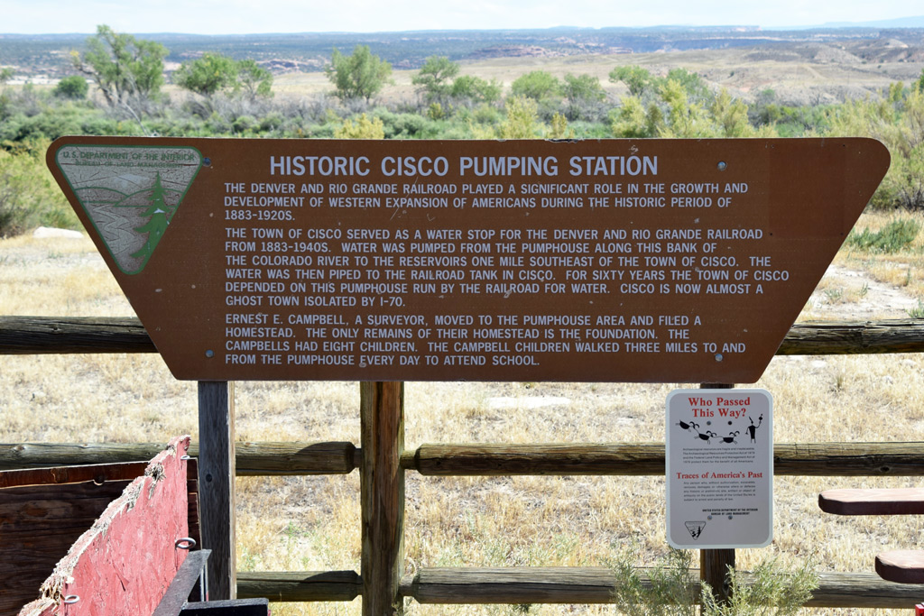
A foundation of a structure is preserved at Cisco Landing.
The BLM marker in front of the remains describes this as the remains of Ernest Elisha Campbell, Sr (1867 – 1937) homestead. But, according to the land patent, his homestead is filed about three miles south of Cisco Landing[11]. Moreover, the site this foundation lies in is within the D&RG property marked in the 1919 ICC Valuation Map. Accordingly, I believe this remains as the foundation of Pump H’se No. 25 represented in the ICC Map.
Represented above for reference is the interior photo of the pump house at Gato, Colorado[10]. The wall made of stone is the point in common. The boiler of the former narrow-gauge Utah & Pleasant Valley Railway locomotive #1 was initially reused to power the pump at Cisco[12].
Pump House [2nd]
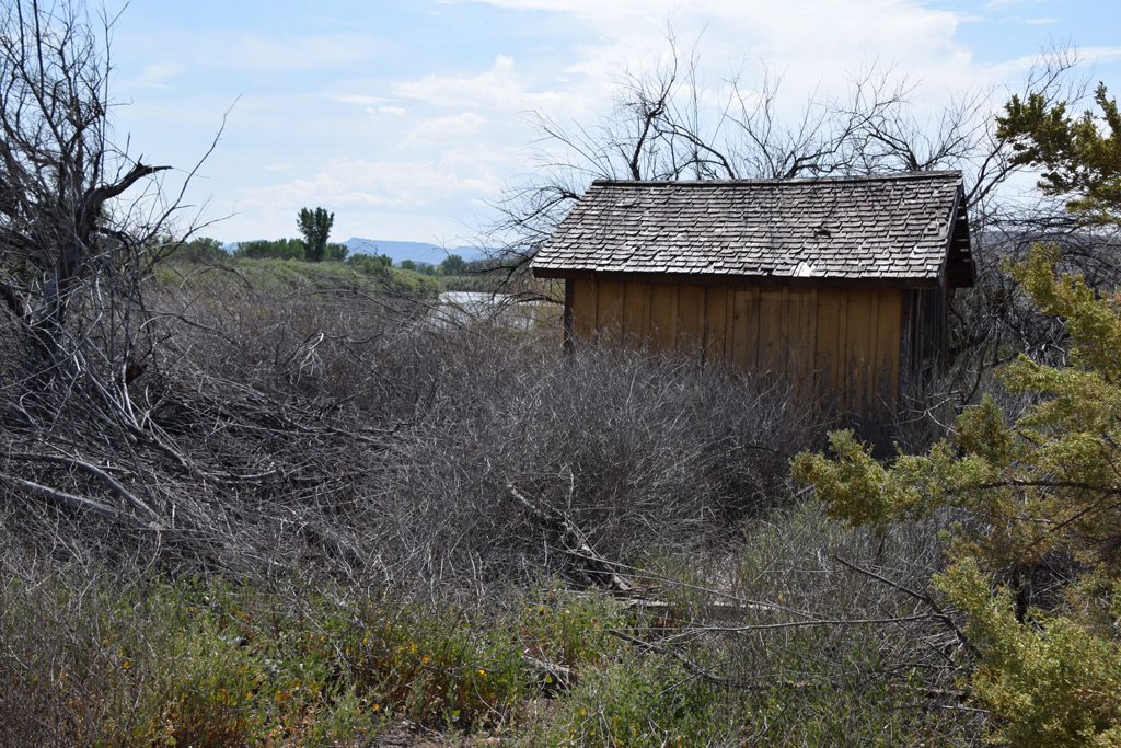 : pump house exterior
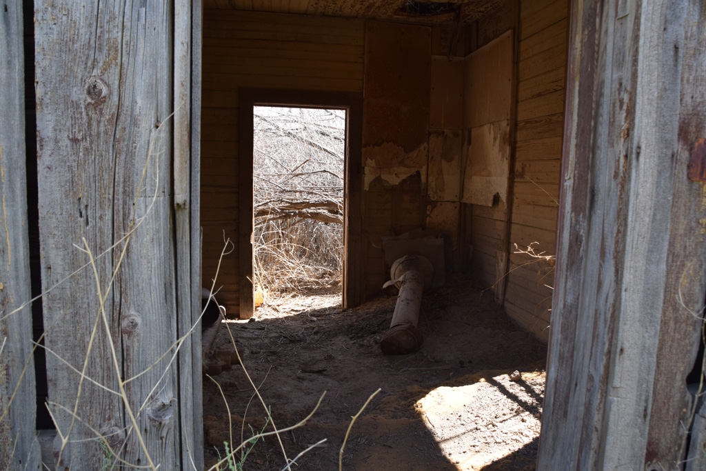 : smoke stack lying inside
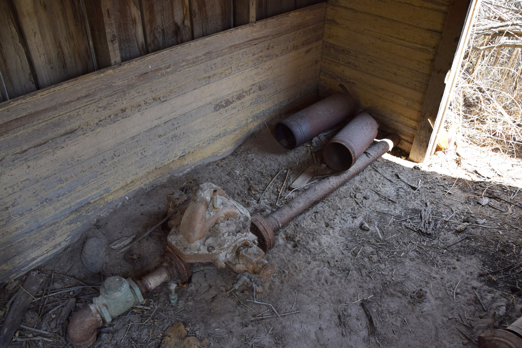 : remains of the plumbing
This little frame structure with a gabled wood shingle roof still stands on the bank of the Colorado River. The structure must have been built when the fuel for the pump was changed from coal to natural gas or gasoline[13]. The entire system seems rebuilt in the 20s[14, 15]. Inside the structure remain an exhaust pipe and pump/plumbing.
revised, Jan. 18, 2018
revised, Aug. 17, 2018
revised, Nov. 2, 2018
revised, Feb. 7, 2021
revised, Mar. 29, 2023
[1] arx (2015) "Rio Grande as a Lifeline – Water Supply at Cisco", Boxcar Red Collection;
[2] Denver & Rio Grande Railroad Colorado/Utah Stateline to Green River, UT ICC Valuation Maps, Colorado Railroad Museum
[3] Feb. 1, 1973 Times-Independent;
[4] Bennett, Lee A., (2009) A History of Selected Ranches on a Twenty-mile Stretch of the Colorado River in Grand County, Utah. Bennett Management Services, LLC
[5] Nov. 1, 1923 Times-Independent;
[6] Mar. 10, 1955 Times-Independent;
[7] Ozment, James (1958) "Charlie Moore Cutting On Water Tank", Sep. 30, 1958, WesternRailImages.com;
[8] Oct. 16, 1958 Times-Independent;
[9] Ozment, James (1958) water tank @ Cisco, UT;
[10] Farnsworth, Vince (2015) "Pagosa Junction Surprise", Farnsworth Scenics;
[11] Campbell homestead entry map;
[12] Strack, Don, (2011) Utah & Pleasant Valley Railway Locomotives, UtahRails.net;
[13] Oct. 15, 1923 Times-Independent;
[14] Jan. 11, 1923 Times Independent;
[15] Jul. 26, 1928 Times Independent;
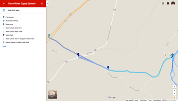 : Cisco Pipe Line system map
シスコの住民が、飲料水・生活用水の供給を鉄道に頼っていたことは以前にも記した。飲料水はタンク車により、生活用水はおよそ6.5キロ離れた水源から鉄道が設置した施設により、シスコに供給されていたのだ。ここではその、「Cisco Pipe Line」と称されていた、大がかりな施設を紹介する。
水源であるコロラド川の河畔には、1919年作成のICC Valuation Mapによると、ポンプ小屋・石炭庫・係員宿舎・便所が設けられた。そして、シスコ・コロラド川間における最高地点には貯水池、シスコには給水塔が設けられた。
国勢調査によると、ポンプ小屋のある地区には係員およびその家族が宿舎に住み込んでいた。近くには何軒かの農家もあり、小学校が開設されていた時期もあったようだ。しかし、鉄道の無煙化とともに、不要となった給水施設は廃止され、現在はポンプ小屋の廃屋などが荒野のなかに遺っている。
ポンプ小屋(初代)
コロラド川のほとり、柵で囲われた中に建物の基礎が保存されている。設置されている看板にはCampbell一家の入植地跡と記されている。しかし、登記簿によれば、この一家の入植地はここからおよそ5キロ下流にある。また、ICC Valuation Mapによると、この一画はRio Grandeの所有地となっている。したがって、筆者は、この建物基礎こそ初代ポンプ小屋のそれだと考える。
ポンプ小屋(2代目)
この木造平屋切り妻屋根の建物が二代目のポンプ小屋である。燃料が石炭から天然ガスに換わった際に建てられたようだ。両妻面に扉、南面に窓が開口する。四畳ほどの室内にはポンプの一部と思われるものや配管、煙突・排気筒の部材、その他が遺されている。
2017-12-01 09:00
コメント(0)
arx_Ph.D. さん

Here represented are my model railroad enthusiasm generated from the photos I took during my childhood at Knoxville, Tennessee, or from the photos I took during my recent trips.
I'm a retired professor of design, meanwhile a part-time associate at the architectural design office in Osaka, Japan where I live with my wife.


コメント 0