Cisco, Cisco, Cisco, part 12 – Cisco, Missouri [Column_Cisco Township]
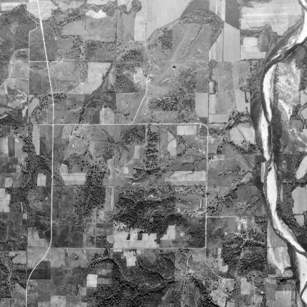 : 1950 USGS Aerial Photo showing the part of Livingston County, MO
I’m trying to build the N scale replica of the town of Cisco, Utah circa 1970. Accordingly, it’s my routine to search “Cisco” on the web, but it goes wrong most of the times bothered by “San Francisco” or “Cisco Systems”. Sometimes, “Cisco, Texas” gets in my way. Thus, I was wondering how many “Cisco”s are there in the United States. My recent research during these Stay Home days revealed some of them. Let me introduce these places named Cisco as a sideshow for my Town of Cisco posts.
Cisco, Livingston, Missouri: the post office at Cisco, MO was located in the home of the postmaster at the northwest section of the Livingston county near the Grundy County border[1, 2]. It was later moved to the ground owned by James Lafayette Walls(1849 − 1927) at GPS coordinates 39.94112, -93.64575[3]. The leading role of the region was farming. The nearest rail connection with Cisco was the Chicago, Rock Island & Pacific at Hickory Creek located seven miles north of the post office.
The Cisco Post Office was operated between 1888 and 1901[4]. Lyda Hosman(1864 – 1936) was the original and the sole postmaster[5]. He also operated a small store[2].
It is said that the name Cisco came from Texas, bounded up with the coming of the railroads[6]. But the history of this place can date back to the 1850s when Cisco, Texas wasn't established yet.
The nearby school was open at least from 1868[2]. The school was originally called Oak Grove District 1[7]. It is said that there was a controversy over whether it should be called Lauderdale or Hosman when the school was renewed in circa 1874[7].
Robert V. Lauderdale(1860 – 1902) was the landowner of the new school ground at GPS coordinates 39.94696, -93.64298[8]. James “Jas” Hosman(1825 ー 1906), the landowner opposite the school might have offered the schoolhouse: James' son, Lyda Hosman took the old schoolhouse as a trade-in[7]. Eventually, Hosman School was the conclusion.
The schoolhouse burnt to the ground in 1923[7]. It was immediately rebuilt same year at GPS coordinates 39.939736, -93.631328, and was continued until 1957[2, 9]. The schoolhouse burnt again to the ground after the closure in 1966[10].
The other settlers at Cisco beside Walls, Lauderdale, and Hosman families found in the 1878 map were; Akers family, Curtis family, Dennis family, Kennedy family, Leeper family, Moore and Preston family, and Strait family[8].
The Cisco settlers found in the 1898 map were; Akers family, Brassfield family, Curtis family, Dennis family, Hosman family, Lauderdale family, Poe family, Prewett family, and Walls family[11].
By 1952, Cisco is fated as one of the little-heard-of sites in Livingston County[12].
As a result, I couldn't find the origin of the name Cisco. Represented above is the USGS Aerial Photo showing the place where Cisco Post Office and the Hosman School once stood.
revised, Dec. 23, 2022
[1] Moser, Arthur Paul, A Directory of Towns, Villages, and Hamlets Past and Present of Livingston County, Missouri, Springfield-Greene County Library;
[2] Oct. 12, 1960 Chillicothe Constitution-Tribune;
[3] Livingston County, Missouri Map published in 1896;
[4] Forte, Jim, Fayette County, Missouri Post Offices, Jim Forte Postal History;
[5] 1890 Official Register of the United States, United States Department of the Interior;
[6] Ramsay, Robert L., (1973) Our Storehouse of Missouri Place Names, University of Missouri Press;
[7] Sep. 13, 1937 Chillicothe Constitution-Tribune;
[8] Township 59, North range 24 West, 1878 map of the Livingston County;
[9] Feature Detail Report for: Hosman School (historical), USGS;
[10] Oct. 18, 1966 Chillicothe Constitution-Tribune;
[11] Some Livingston County Residents, 1898 Atlas and plat Map;
[12] Feb. 22, 1952 Chillicothe Constitution-Tribune;
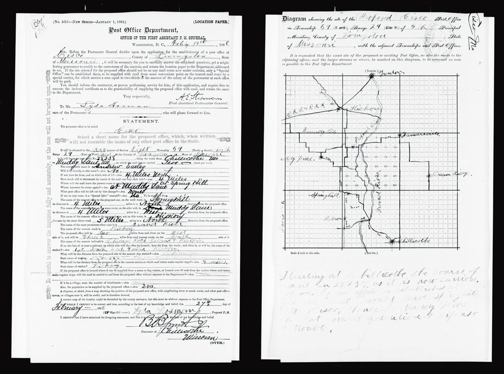 : 1888 Report of Site Location for Cisco Post Office
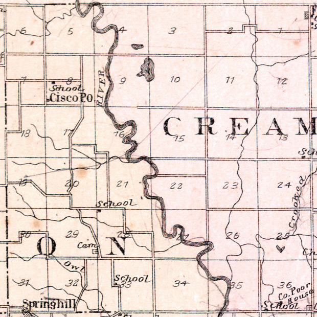 : 1896 Livingston County Map
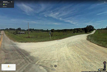 : Google maps, Cisco, MO
筆者がNスケールで復元しようとしているユタ州Ciscoについて調べようとインターネット検索すると、余計なページばかりよく引っ掛かる。最も邪魔なのはSan Francisco、次いで邪魔なのはCisco Systemsに関連するページである。テキサス州にあるCiscoという町に関連するページも結構邪魔だ。一方、お目当てのユタ州Ciscoの町に関連するページなどほとんどない。一体何件の「Cisco」がアメリカにあるのか。古い郵便局一覧を調べてみると、ユタ州Cisco以外に 14カ所ものCisco郵便局があったらしい。どんなところだろう。
Cisco, Missouri: 二カ所目のCisco郵便局は、ミズーリ州Livingston郡の北西部、Grundy郡との境界の程近くに1888年開局した郵便局である。初代の郵便局長はLyda Hosmanというひと。1901年まで開いていた。
郵便局最寄りのHosman小学校は1868年までに開校し、1957年まで続いた。学校の敷地はRobert V. Lauderdaleというひとの提供、校舎は初代郵便局長Lyda Hosmanかその父James Hosmanが提供したようだ。郵便局および学校の位置は分かるが、地図や航空写真を調べても、集落があったような様子はない。名前にCiscoを含む住人がいた様子もない。すなわち、郵便局名Ciscoが何を指すのか分からなかった。
2020-10-23 09:00
コメント(0)
arx_Ph.D. さん

Here represented are my model railroad enthusiasm generated from the photos I took during my childhood at Knoxville, Tennessee, or from the photos I took during my recent trips.
I'm a retired professor of design, meanwhile a part-time associate at the architectural design office in Osaka, Japan where I live with my wife.


コメント 0