Cisco, Utah 84515 [Column_Cisco Range]
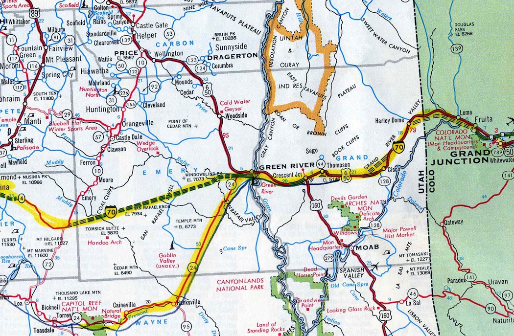 : Cisco shown in 1969 Texaco Touring Atlas (our travel route traced in yellow)
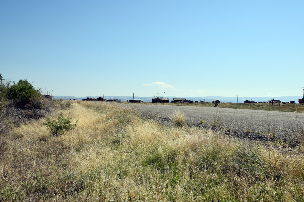
The town of Cisco lay in the middle of the barrens of southeastern Utah, along the US Hwy 50 & 6 between Grand Junction, CO and Green River, UT. Our family went through the town in the summer of 1971 in our white 1964 Oldsmobile, en route from the Rocky Mountain National park to the Bryce Canyon National park.
The route in Utah was boring for a ten-year-old boy. My interest was only devoted to the Denver & Rio Grande Western Railroad track running along the route. I had certainly been there, but remember little of the town: Cisco was almost dying at that time.
On the contrary, the town is well known to some kinds of people from that time to this day. Not only movie creators but musicians and passing travelers are also fascinated by the town. The dying town must have had some sort of glamour for them. Why? We will closely examine the glamour of Cisco in the following posts.
Here is a brief history of Cisco.
Cisco was settled as a railroad siding/water stop on the Denver & Rio Grande Western Railway in 1883: the rail reached Cisco from the east on February 3 and the first through passenger train ran on April 8 from Salt Lake City.
The origin of the name is uncertain, but it might be named for nearby Cisco Wash. Cisco Wash itself is a revised geographical name of Alkali Creek.
The latest appearance of the original name Alkali Creek along with the nearby Muddy Creek and Desert Creek was found in the map surveyed in between 1874 and 1876 and printed in 1881 by Ferdinand Vandeveer Hayden(1829 ー 1887)[1].
The renaming of Alkali Creek to Cisco Wash, Muddy/Saleratus Creek to Sagers Wash, and Desert Creek to Cottonwood Wash, all on the right bank of the Colorado(Grand) River where the railroad was constructed, arose at the same time between 1881 and 1883.
It seems that they were renamed during the planning/construction of the railroad, because the streams on the left bank of the Grand(Colorado) River bank like Granite Creek and Little Dolores River, keep their names to this day.
The sidings/stations along the railroad settled in 1883 claimed the revised Wash names in this section: "Cottonwood", "Cisco", and "Sagers" from east to west. The railroad possibly thought them more attractive to the passengers and settlers than "Desert", "Alkali", or "Saleratus".
The word Cisco itself is said to be a French Canadian borrowing from Ojibwa for a kind of whitefish of an oily nature[2]. But, a Spanish word meaning slack(dust coal), or a Spanish word meaning disturbance, or a Spanish boy's name meaning Frenchman or free man, and or the sidekick name of Francisco would be more adequate for the origin of Cisco/Cisco Wash.
Here are some hints:
The Cisco Wash rises in the Book Cliffs coalfield not far from the Sego mine which produced anthracite coal until 1955.
St. Louis-born Frenchman Antoine Robidoux(1791 ー 1860) left one of the oldest inscriptions in the region at nearby Westwater Creek in 1837.
A surveyor Francis Hodgman(1839 ー 1907) attended one of the thirty-six surveying and locating teams the Denver & Rio Grande Western Railway dispatched to the region between 1881 and 1882[3].
The Cisco Post Office was established in 1887 by John Samuel Martin(1852 – 1918). When the railroad relocated and standard-gauged its tracks in 1890, the depot and the post office also relocated two miles southeast to the present location. The Cisco Townsite was established in 1910 by Victor Putman Hanson(1841 ー 1920) within his 160 acres homestead patented on June 16, 1906[4, 5, 6].
Cisco was a loading point for ore, wool, sheep, and cattle produced in the region. According to 1951 Rio Grande General Traffic Department Circular, Cisco had three pens for cattle, five pens for sheep, two chutes, and water & scales facilities. However, unfortunately, the water facilities were dismantled in 1958, and the corrals were removed by 1972[7, 8].
Cisco was also a supply point for daily necessities among farmers, miners, and railroad workers living in the region. The town had a population of over 100 at its peak in 1930 according to the Census. Two hotels, three stores, two restaurants/saloons/pool bars, and a garage served the community according to the 1919 Interstate Commerce Commission (ICC) Valuation Map.
Nevertheless, the town stretched only a one-third mile along with the Railroad Street, later US Highway 50 & 6, at its peak. Dieselization of the railroad in the 50s led the water point to decay, so as did the town because it also relied on the railroad for the water. The discovery of natural gas, uranium, and crude oil temporarily sustained the town. However, inevitably, the passing traffic, which was the town's mainstay, dried up when Interstate 70 bypassed the town in 1973.
Cisco isn't a town anymore, Hemphill wrote in 1985[4]. The attempt and the failure of constructing hazardous waste incinerating facilities through consolidating the townsite plats from the 70s to 1988 sealed the tiny town's fate[9, 10].
[1] Hayden, F.V., (1881) Composite: Colorado. V-X., Department of The Interior. United States Geological and Geographical Surveys of the Territories;
[2] Gannett, Henry (1905) The Origin of Certain Place Names in United States, Washington Government Printing Office
[3] Thode, Jackson, Ozment, James L., (1993) In the mountains of utah, Dreams, Visions and Visionaries: Colorado Rail Annual, No 20, Colorado Railroad Museum
[4] Hemphill, Mark W., (July 1985) The Unknown Rio Grande, Trains, Kalmbach
[5] Stocks, Verona, (1972) Grand Memories, Daughters of Utah Pioneers
[6] Cisco Homestead patent-Victor Hanson;
[7] May 28, 1972 Daily Sentinel;
[8] Ozment, James (1958) Water Tank@Cisco, UT;
[9] Nov. 4, 1987 Deseret News;
[10] Nov. 11, 1988 Deseret News;
revised, Feb. 3, 2015
revised, Dec. 8, 2015
revised, Aug. 29, 2016
revised, Jan. 11, 2017
revised, Mar. 17, 2019
revised, Jun. 21, 2020
revised, Dec. 22, 2020
revised, Jul. 31, 2021
revised, Jan. 26, 2022
revised, Jan. 29, 2023
 : Dotsero, CO. Summer, 1971
 : Emery, UT. Summer 1971
2013-04-19 09:00
コメント(2)
Preceding Studies of Cisco [Column_Cisco Range]
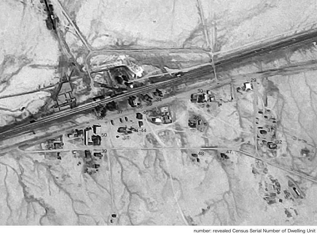
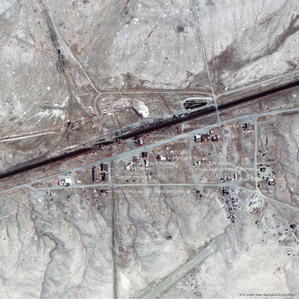 : identified townscape filled in 1974 USGS aerial photo
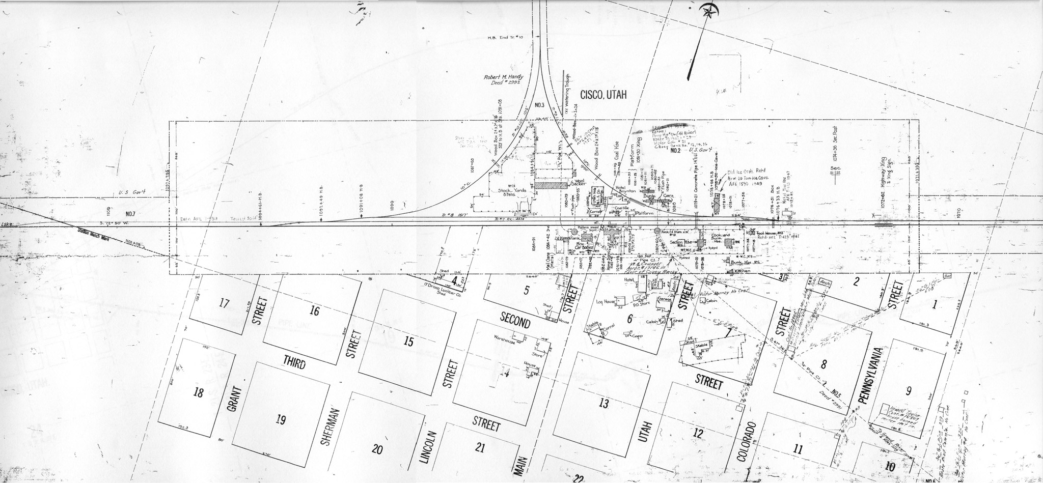 : ICC valuation map, courtesy of Utah State Archives
 : Plat, courtesy of Grand County
As the town is now declined into a ghost town, we have little information on how it was in the 70s at the site today. Accordingly, I went to find records to restore the townscape.
Interstate Commerce Commission (ICC) Valuation Map, drawn in 1919, revised in 1949, at Utah State Archives shows Cisco Townsite[1].
As far as I researched, Sanborn Maps for Cisco wasn't found on the web.
U.S. Geological Survey (USGS) Aerial Photo also helps identifying the lost townscape[2].
Census of the United States from 1900 provides information on people who lived in the town.
Utah Digital Newspapers site has a collection of Grand Valley Times and its successor the Times-Independent, a Grand County local newspaper issued between 1896 and 2005[3]. Newspapers. com has a collection of Grand Junction local newspaper The Daily Sentinel which occasinally features Cisco from 1893 to this day.
Kathy Jordan, a former The Daily Sentinel editor at Grand Junction, CO describes short stories related to Cisco[4]. Thanks to her articles, we can know the outline of the town.
Mary L. Hepperle, a former Cisco resident describes her memories of the town[5]. She added a hand-written map of the town in the early 50s to her articles.
Norman D. Weis, a photographer/author visited the town in the early 70s, no later than 1975. His article and photos appear on the ending pages of his book Helldorados, Ghosts and camps of the old Southwest.
Lee A. Bennett, an archeologist researched the history of ranches along the Colorado River in Grand County[6]. The early days of Cisco are mentioned in the article.
The movie Vanishing Point went location at Cisco in June, 1970[7]. The opening and the last scene of the movie were shot in this tiny town[8]. We can see almost all the 70s sequence of the town in this movie, which I hardly remember.
The people who were enchanted with the ruins uploaded lots of photos of Cisco on web pages. Thanks to these photos, we can infer some structures.
Eventually, the picture above shows the results of my survey; identified structures plotted on the 1974 USGS aerial photo representing the townscape in the early 70s.
revised Sep. 22, 2014
revised Dec. 16, 2014
revised Jan. 11, 2015
revised Feb. 4, 2015
revised Oct. 3, 2016
revised Jan. 21, 2017
revised Aug. 22, 2021
[1] Department of Transportation. Division of Right of Way Railroad Maps, Denver & Rio Grande Western Railroad: MP 503 to MP 504, including Cisco, Utah (MP 504), shows wye at Cisco, scale 1=100', Series 28224, H-150, Utah State Archives;
[2] USGS EarthExplorer;
[3] Utah Digital Newspapers site
[4] Jordan, Kathy "‘Uranium King’ Charlie Steen started out in Cisco tarpaper shack", Mar. 24, 2011 Daily Sentinel;
[5] Hepperle, Mary L (2004) "Memories of Cisco", Canyon Legacy, vol. 51, Dan O'Laurie Canyon County Museum;
[6] Bennett, Lee A. (2009) A History of Selected Ranches on a Twenty Mile Stretch of the Colorado River in Grand County, Utah, "Research Project", #77, Bennett Management Services;
[7] Vanishing Point Behind the Scenes web page;
[8] Vanishing Point trailer at YouTube;
 : Cisco, UT. Sep. 11, 2014
2013-04-26 09:00
コメント(0)
Water Supply at Cisco, Part 1 [Column_Cisco Range]
 : 1940 Plat indicating the pump house at Cisco Landing
Both man and railroad need water to survive. Accordingly, the water supply was always a concern along the Denver & Rio Grande Western Railroad routes in eastern Utah.
Wells/Windmills are generally used to draw water in the wide plains. But they were/are rare along the Rio Grande in Utah; water veins were too deep or poor in quantity and/or quality[1].
For example, the well the Rio Grande drilled turned out to be a mineral geyser unsuitable for steam locomotives at Woodside, northwest of Green River[2]. The State Board of Health ordered the Rio Grande to stop supplying water to the town of Thompson due to its poor quality[3]. 1200 feet depth well shed sulfurous water at Cisco[4].
Fortunately, Green River had the namesake river, and Thompson had a spring. But Cisco lacked an adequate water source. Accordingly, when the Rio Grande completed the through the line in 1883, the railroad set up a steam-powered pump at Cisco Landing, on the bank of the by-then Grand (today, Colorado) River four miles east of Cisco, to feed their narrow gauge steam locomotives.
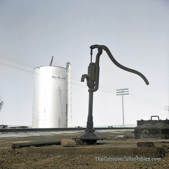
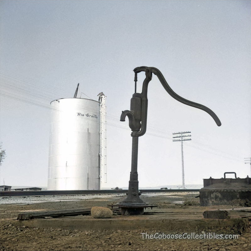
The water supply system the Water Service Department of the Rio Grande installed was finally developed to 4.3 miles of 6-inch pipe, two 400,000 gallon reservoirs, and two wooden water tanks by the depot[4, 5, 6]. In 1928, a 100,000-gallon steel tank replaced wooden water tanks by Stearns-Rogers Construction Company of Denver, Colorado[7].
The remnants of the pair of reservoirs can be seen on Google Maps: steel tank by the depot is gone today[8, 9].
The Colorado River water supplied by the Rio Grande treated not only steam locomotives but also Cisco residents for use as culinary water. Drinking water for the residents was also supplied by the railroad from a tank at Whitehouse, five miles west of Cisco, by special tank cars[10]. Residents used milk cans to haul water from the depot. Accordingly, the Rio Grande was a lifeline for the town of Cisco.
But the Rio Grande proposed the plan of quitting both culinary and drinking water supply in 1955; steam locomotives were retired[4]. Neighbors, like the city of Green River, bought the water supply system from the railroad[11]. But Cisco residents chose to carry their own drinking water from nearby Thompson by their own hand since the abolition of the facilities in 1958[12, 13, 14].
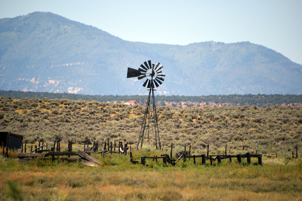
Thus, wells/windmills aren’t popular in this region. But, I think they are symbolic icons of rural America. Here are some of them I found, a little far from Cisco.
AERMOTOR written at the tail wing represents the mill manufacturer established by La Verne Noyes in 1888 in Chicago IL. Today, the company is still active and says that it is the only windmill manufacturer in the United States[15].
revised, Jul. 21, 2015
revised, Mar. 25, 2016
revised, Nov. 15, 2016
revised, Jan. 12, 2017
revised, Sep. 20, 2017
revised, Oct. 19, 2018
revised, Apr. 17, 2019
revised, Apr. 6, 2022
[1] Nov. 26, 1936 Times-Independent;
[2] Mar. 23, 1972 Park Record;
[3] Jan. 12, 1933 Times-Independent;
[4] Mar. 10, 1955 Times-Independent;
[5] Jul. 26, 1928 Times-Independent;
[6] Ozment, James (1958) Water Tank@Cisco, UT;
[7] Jul. 19, 1928 Times-Independent;
[8] Cisco water supply system map;
[9] Oct. 16, 1958 Times-Independent;
[10] Dalton, Vonna Foy, (2004) Some Remembrances of Picture Gallery and Cisco, Canyon Legacy, Vol. 51, Dan O'Laurie Canyon County Museum
[11] Sep. 22, 1955 Green River Journal;
[12] Farewell, R.C., (1999) Rio Grande Secret Places Vol. Two, Colorado Railroad Museum
[13] Ozment, James (1958) Water Tank@Cisco, UT;
[14] Jan. 22, 1970 Times Independent;
[15] Aermotor Windmill Company homepage;
 : US Hwy 191, Monticello, UT Sep. 12, 2014
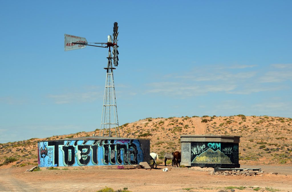 : Indian Route 6230, Tonalea, AZ Sep. 13, 2014
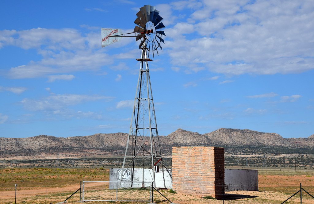 : Indian Route 21, Cameron, AZ Sep. 14, 2014
2015-07-03 09:00
コメント(0)
Highway Through Cisco [Column_Cisco Range]
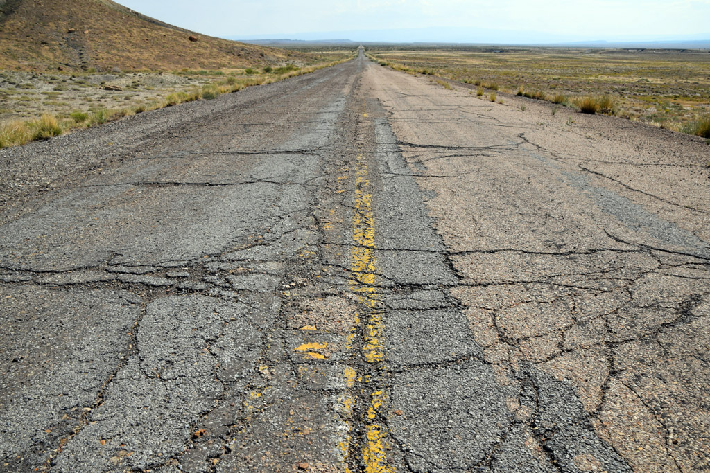 : old US Hwy 50 & 6 near Cisco, UT Sep. 10, 2017
Cisco, Utah was truly a railroad town. The town relied on the Rio Grande for its establishment and also for its survival. But utilities other than the railroad also made some contribution to its survival. Here is the story of how other utilities supported this remote tiny town in the desert.
Far before the motor age, the region called Utah today was covered by the Indian trail network.
In the frontier era, pioneered by Mexican trader Antonio Armijo in 1829, three routes connecting Santa Fe, NM, and Los Angeles, CA called the Old Spanish Trail crossed the region. One of which called the Northern Branch of Old Spanish Trail passed through the places later called Westwater, Cisco Landing, Thompson, and Green river.
In 1858, the Trail was improved by US Army Colonel William Wing Loring(1818 − 1886) enabling them to carry wagons, and the route became known as Salt Lake Wagon Road. But the town of Cisco didn’t arise yet.
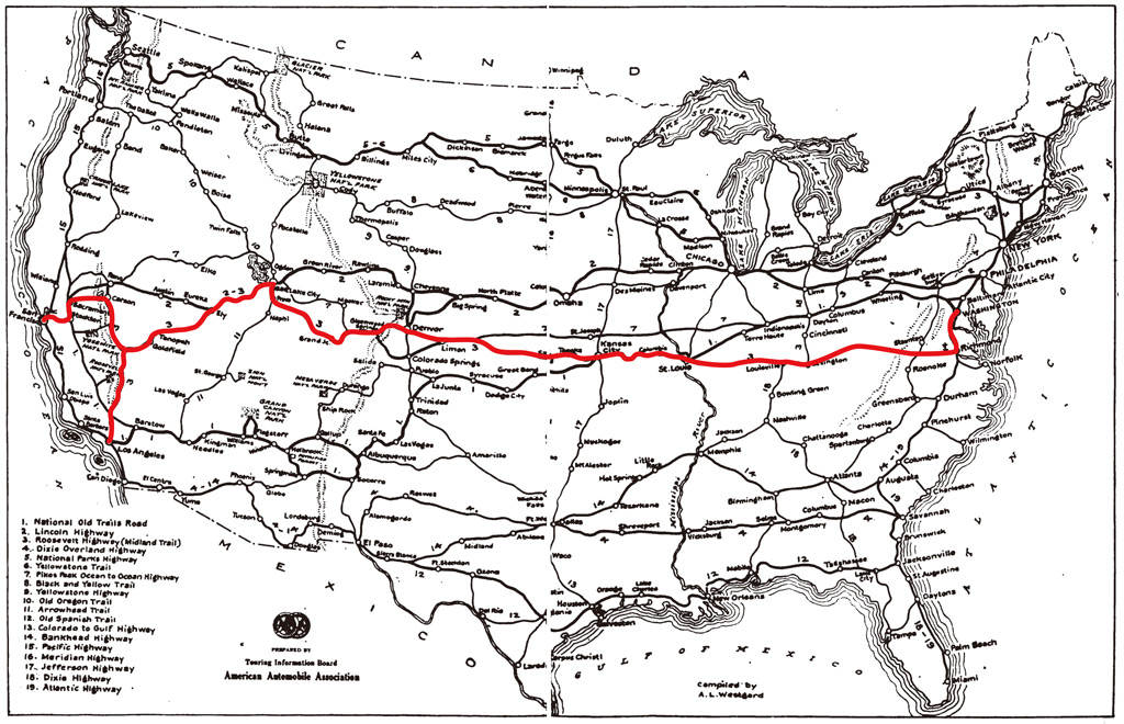 : map of Midland Trail
 Midland Trail, one of the first transcontinental autoroutes, was routed through the town of Cisco In the early 1910s tracing the predecessors which took 33 hours just to go from Mack, CO to Cisco[1]. The Trail was promoted by the Midland Trail Association backed by Salt Lake Tribune. The construction of the route within Grand County, partially reusing abandoned narrow-gauge railroad right of way, was completed in 1913[2]. But it was nothing more than a dirt wagon trail at that time.
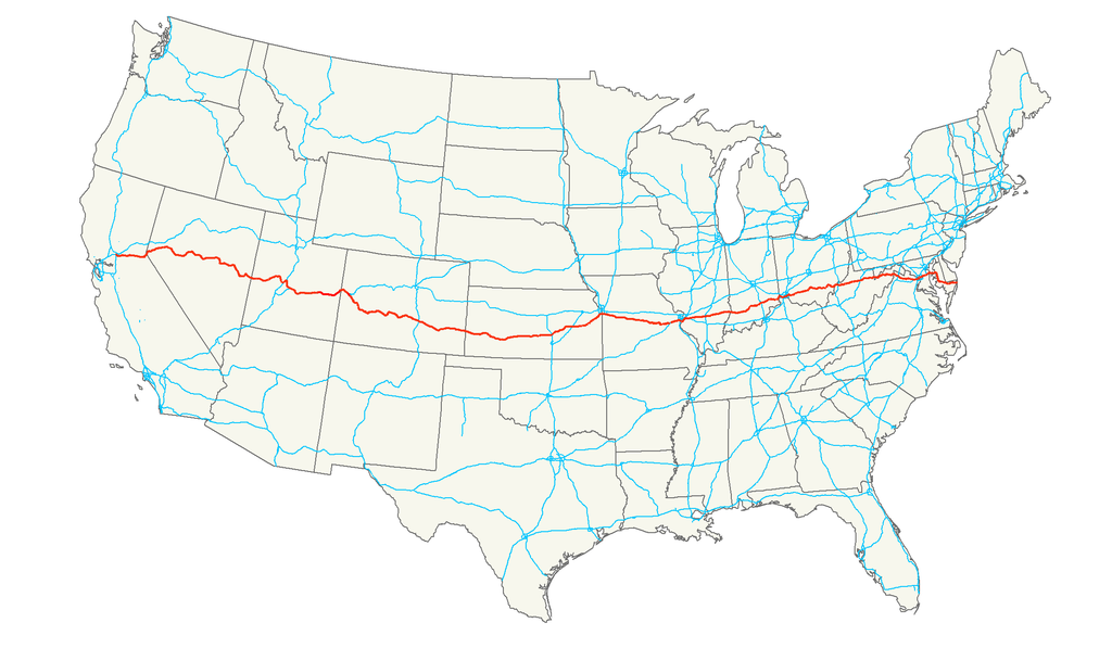 : map of US Hwy 50
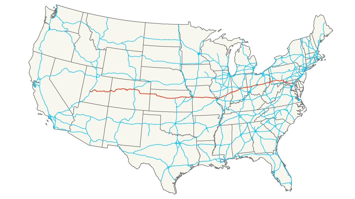
US Route 50 (US Hwy 50), known as The Loneliest Road in America, connecting Sacramento, CA and Annapolis, MD was created in 1926 as a result of the Federal Aid Highway Act of 1925. Midland Trail within Grand County was designated as Route 50.
Reconstructing of the Trail to federal aid standard highway between Cisco and Colorado state-line was completed in 1931[3]. The contractor was Hall-Lumsden Construction Company of Grand Junction, CO. The portion, including the one-half mile stretch through the town of Cisco, was oil-surfaced in 1934[4, 5]. Westward from Cisco was delayed due to the state’s negotiation with D&RGW about obtaining rights of way through the railroad’s Floy gravel pits[6]. The remnants of the gravel pits penetrated by the highway can be still seen in Google maps satellite view.
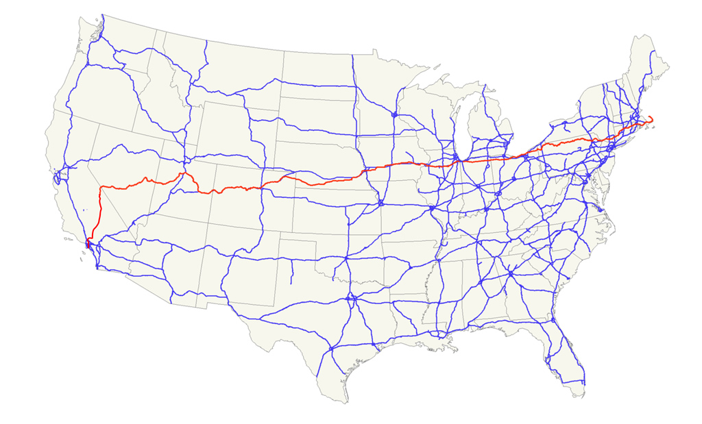 : map of US Hwy 6
US Route 6 (US Hwy 6), described as route runs uncertainly from nowhere to nowhere by a historian George R. Steward, connecting Long Beach, CA and Provincetown (Cape Cod), MA, was first designated in 1925[7]. The portion within Grand County was designated in 1937. It was the longest highway in the United States at that time. The route traced US Hwy 50 within Grand County[8].
The US Route 6 gradually designated the Grand Army of the Republic Highway, honoring the Civil War soldiers, between 1937 and 1948. It was also the Roosevelt Highway since 1936. Jack Kerouac(1922 – 1969) mentioned the route in his 1957 Nobel On the Road.
 : map of I-70
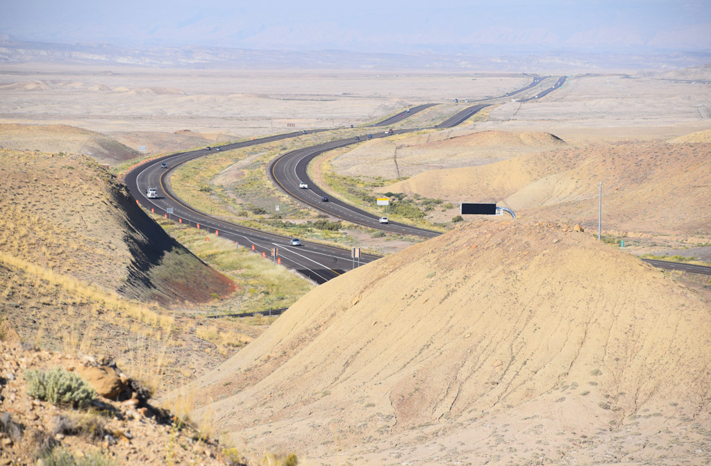
Interstate 70 (I-70) which had come to bypass Cisco began to construct at several sections within Grand County in the early 70s[9]. The last portion of I-70 in Grand County was finally completed in 1976[10]. Unfortunately, however, the seasonal elasticity of the Mancos Shale formation where I-70 lays caused buckling and heaving of the Interstate's pavement. Accordingly, it had to be reconstructed soon after its completion[11]. The portion in Grand County was designated National Scenic Byways in 2002.
 : I-70 near Brendel, Utah Sep. 11, 2014
After the completion of the Interstate, the portion of old US Hwy 50 & 6 between I-70 Exit 204 and 214 became Utah State Route 128 (SR 128). SR 128 was also designated National Scenic Byways in 1998[12]. The portion of US Hwy 50 & 6 west of Exit 204 became Grand County jurisdiction Frontage Road[13].
 : Mack, CO. Sep. 10, 2017
About that time when US Hwy 50 was completed, the state of Utah set up a highway maintenance station at Cisco, along with Elgin and Moab in Grand County[14]. The station was located in the easternmost of the town.
Several engineers were stationed according to the 1930 Census. Victor Kirby Murray(1893 – 1962), considered as one-time owner of the Ruth’s 66 Cafe structure, was the foreman[15]. Harry Ballard Harris(1914 – 2005), later husband of Ruth of Ruth’s 66 Cafe, was also the foreman[16]. However, unfortunately, the station was moved to Thompson in 1975[17, 18].
 : Sep. 10, 2017. Thompson Springs, UT
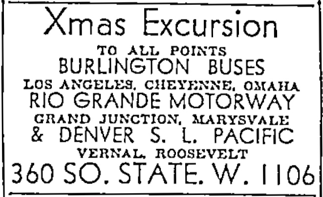
Bus Routes through Cisco and the vicinity was inaugurated in 1935, soon after the completion of the US Hwy 50, by the Rio Grande Motorway Inc., later, by the Rio Grande Trailways, a unit of National Trailways Bus System since 1936[19, 20].
The Motorway/Trailways bus initially connected Salt Lake City and Pueblo via Hwy 50, the route obtained from Southern Kansas Stage Lines[20]. It later added the Denver portion via Hwy 6 in 1937[21].
According to the April 1945 Rio Grande Trailways Bus Timetables, westbound departed Cisco at 3:29, 10:54, and 23:39, all for Salt Lake City, and eastbound departed Cisco at 5:06 for Pueblo, 14:26 for Pueblo, and 20:11 for Denver. It took about 7 hours to S.L.C., 11 and a half hours to Pueblo, and 12 hours to Denver.
The Motorway passenger operations were sold to Continental Trailways in 1948[22]. According to June 1971 Continental Trailways Timetable, westbound departed Cisco at 18:50 for Salt lake City and eastbound departed Cisco at 5:14 for Denver. It took about 5 hours and a half to S.L.C., and 10 hours to Denver. However, unfortunately, Cisco stops apparently ended up in 1973/4 due to the progress of Interstate construction: the portion of I-70 bypassing the town began to use on Nov. 16, 1973.
Today, Greyhound Lines buses connecting Las Vegas and Denver run through the region on I-70, with the nearest stop from Cisco at Green River, Utah, or Grand Junction, Colorado.
 : Dec. 5, 1935 Salt Lake Telegram
 : Mar. 26, 1936 Springville Herald
 : Mar. 6, 1964 University of Utah Student Newspapers
Air Routes can also be considered as utilities in this region.
The YouTube movie below shows the approach to the remnants of Rogers Roost Airport at Thompson Springs west of Cisco. We can see similar remnants of an airstrip at Cisco itself, on the hill south of the former schoolhouse site.
The runway of Cisco is clearly seen at the southern end of Main Street in the 1952 USGS aerial photo, which is not found in the 1944 USGS photo. It was maintained by County Commissioner Frank Martin Shields(1896 − 1983)[23]. He owned a ranch near Cisco[24].
According to the interview with former pilot Dennis Earl Byrd Sr(1921 − 2007), mining companies and oil companies used private airplanes in this region[25]. He did fly Charles Steen's Cessna 195 to Cisco in 1953[26].
The dirt Cisco runway measured 2300 feet long and 70 feet wide, according to Brooks[27]. The 1969 USGS photo shows the replaced access road. Accordingly, it seems that the airstrip was used at least until the late 60s.
 : Jul. 21, 1955 Green River Journal
revised, Mar. 4, 2016
revised, Mar. 10, 2016
revised, Mar. 25, 2016
revised, Jan. 12, 2017
revised, Oct. 16, 2017
revised, Apr. 27, 2018
revised, Dec. 14, 2018
revised, Apr. 15, 2019
revised, Nov. 22, 2019
revised, Aug. 4, 2021
revised, May 16, 2022
[1] Nov. 15, 1912 Grand Valley Times;
[2] Jul. 11, 1913 Grand Valley Times;
[3] Apr. 30, 1931 Times-Independent;
[4] May 10, 1934 Times-Independent;
[5] May 31, 1934 Times-Independent;
[6] Feb 9, 1933 Times-Independent;
[7] Weingroff, Richard F. (2015) "U.S. 6 - The Grand Army of the Republic Highway", Highway Story, Federal Highway Administration;
[8] Dec. 31, 1936 Times-Independent;
[9] Sep. 6, 1973 Times-Independent;
[10] Firmage, Richard A., (1996) A History of Grand County, p.364, Utah State Historical Society;
[11] Apr. 22, 1976 Times-Independent;
[12] Jul. 16, 1971, Highway Resolutions, p.22, Utah Department of Transportation;
[13] Sep. 17, 1973, Highway Resolutions, p.29, Utah Department of Transportation;
[14] May 7, 1942 Times-Independent;
[15] Dec. 13, 1962 Times-Independent;
[16] Dec. 18, 2005 Deseret News;
[17] Jun. 1, 1972 Times-Independent;
[18] Rogers, A.J., (2018) "A Page Out of the Book Cliffs Page 35", Dec. 14, 2018, Times-Independent;
[19] Aug. 5, 1935 Salt Lake Telegram;
[20] Hobijn, Jon, Jon's Trailways History Corner website;
[21] Feb. 26, 1937 Pleasant Grove Review;
[22] Feb. 26, 1948 Times-Independent;
[23] Sep. 28, 1950 Daily Sentinel;
[24] Aug. 16, 1951 Times Independent;
[25] Dahl, Detta, (2003) Dennis E. “Pete” Byrd, Sr., Eastern Utah Human History Library;
[26] Byrd, Dennis E., (1997) Early Flying In Grand County, Vol. 30, Canyon Legacy, Dan O'Laurie Canyon County Museum
[27] Brooks, David W. (2012) Open and Closed Listing of Airports / Airfields;
* 1938 photo of Rio Grande Trailways coach #179 found at Jon's Trailways History Corner website;
2016-01-08 09:00
コメント(0)
Telephone Line Through Cisco [Column_Cisco Range]
 : Yanahara, Okayama, Japan
Cisco was truly a railroad town. It relied on the Rio Grande for its establishment and survival: I wrote before about how the town relied on the railroad for the water. But utilities other than the railroad also contributed to Cisco's survival. Here is the chronological story of how other utilities reached this remote tiny town in the desert.
Telephone Line was the first utility besides the railroad to serve the town of Cisco. It made some contribution to the survival of the town. For example, Moab residents communicated with the railroad agent at Cisco in advance to ship or travel by train from the town.
In 1911, a telephone line from Moab to Cisco was installed by La Sal Mountain Telephone & Electric Company, which was organized in 1903 by Justus(Justin) Noyes Corbin(1858 – 1923) and managed by William Jasper Meador(1865 – 1925) at that time[1].
In 1915, Corbin’s second company, Midland Telephone Company installed the line from Grand Junction CO. to Cisco and to Green River along the Midland Trail[2]. Public phones were located every mile on the telephone poles along the Trail. In 1926, Mountain States Telephone & Telegraph Company added another transcontinental phone line through Cisco[3].
In 1963, the Midland Telephone Company merged into Independent Telephone Corporation, and in 1964, ITC merged with Continental Telephone Company to form Continental Independent Telephone Corporation, which became Continental Telephone Corporation next year[4, 5].
In 1974, the Continental Telephone Corporation subsidiaries Midland Telephone Company and Utah Telephone Company merged to form Continental Telephone Company of Utah, and the name Midland finally vanished[6].
Even in the 40s, telephone at the Capansky’s was the only civilian phone in the town[7]. The phone number for the Capansky’s was "Cisco 2" according to the ad on July 21, 1955 Green River Journal. The number "Cisco 1 and 3" was obtained by Cisco Mercantile[8, 9]. The number "Cisco 2" was later succeeded by Ethel’s Cafe at least in 1976[10].
Mike Brown recalls that Cisco in 1978 might have been one of the last places in the United States without dial phones, and the phone number for by that time Cisco Desert Sun Inn, former Ethel’s Cafe, was "Cisco 8"; the situation in the 70s was nothing changed from the case declared on April 16, 1925 Midland Telephone Company Ad[11].
revised, Jun. 4, 2020
revised, Aug. 1, 2021
revised, May 16, 2022
[1] Sep. 22, 1911 Grand Valley Times;
[2] Sep. 21, 1915 Daily Sentinel;
[3] Jul. 29, 1926 Times-Independent;
[4] Dec. 12, 1963 Times Independent;
[5] Palmer, Jay, (1999) "May I Have Your Nunmer, Please?", Vol. 37, Canyon Legacy, Dan O'Laurie Canyon County Museum
[6] Jan. 17, 1974 Tremonton Leader;
[7] Mary L. Hepperle, (2004) "Memories of Cisco", Canyon Legacy, vol. 51, Dan O'Laurie Canyon County Museum;
[8] Nov. 16, 1947 Daily Sentinel;
[9] Sep. 19, 1966 Daily Sentinel;
[10] Oct. 7, 1976 Times-Independent;
[11] Brown, Mike (2014) "127 thoughts on 'A Conversation That Actually Just Happened'", Whatever;

left: Apr. 16, 1925 Times Independent, right: Jan. 19, 1968 Ephraim Enterprise
2017-01-20 09:00
コメント(0)
Gas and Power Line Through Cisco [Column_Cisco Range]
 : Cisco, UT Sep. 11, 2014
Cisco was truly a railroad town. It relied on the Rio Grande for its establishment and survival: I wrote before about how the town relied on the railroad for the water. But utilities other than the railroad also made some contribution to the survival of Cisco. Here is the chronological story of how other utilities reached this remote tiny town in the desert.
Oil and natural gas were once produced in the vicinity of Cisco. They made some contributions to the town's survival: Cisco was the first town in eastern Utah to have natural gas service at home.
Gas Line was installed throughout the town in 1923 by Arizona-Utah Oil & Gas Company to provide natural gas extracted from a gas well located the north of town in Cisco Townsite-Cisco Wash Fields[1]. Arizona-Utah Oil & Gas Company drilled the gas well to fuel oil well drilling at Cisco Dome Field the company started in 1921[2].
Arizona-Utah's natural gas was also provided at Cisco Landing to run the D&RGW pump produced by A. S. Cameron Steam Pump Works[1]. Before the arrival of the power line, some of the private generating plants set up at Cisco also burned natural gas[3].
As early as 1925, G L Emil Klingbeil(1863 –1930) of German-American Life Insurance Company resumed the Arizona-Utah's well operations[4].
Today, both the well operations and the gas service at Cisco are faded out. But the oil and gas interests from these fields included in Greater Cisco Field seem still held by Reno, NV based Pacific Energy & Mining Company.
 : Nov. 11, 1918 Salt lake Herald
Power Line didn't arrive at Cisco until the town has declined.
Nearby Moab had its first electric light in 1915 provided by Moab Light & Power Company[5]. Utah Power & Light Company, who in 1926, took over the Moab Light & Power Company, completed 100,000 volts power line between Helper and Moab in 1955[6]. The company expanded it to 345,000 volts in 1971[7].
In 1962, San Miguel Power Association’s 120-mile power line from La Sal Junction to Harley Dome oil field 20 miles north of Cisco finally dropped in at the town[8]. In short, the Cisco hook-up was just an addition. San Miguel merged into Utah Power & Light Company in 1972.
 : Feb. 2, 1955 Vernal Express
 : Sep. 29, 1955 Green River Journal
Today, it seems no line but the power line survives. On the other hand, Emery Telecom started providing DSL from the station at the former D&RGW depot site. The fiber optic cable is buried along the former Rio Grande main[9].
[1] Nov. 15, 1923 Times-Independent;
[2] Jul. 28, 1921 Times-Independent;
[3] Dec. 9, 1954 Times-Independent;
[4] Apr. 23, 1925 Times-Independent;
[5] Feb. 12, 1915 Times-Independent;
[6] Sep. 15, 1955 Green River Journal;
[7] Dec. 17, 1970 Times-Independent;
[8] May 24, 1962 Times-Independent;
[9] Patterson, Steve (1993) Remarks & Notes, RailPictures.Net;
2017-03-03 09:00
コメント(0)
Water Supply at Cisco, Part 2 [Column_Cisco Range]
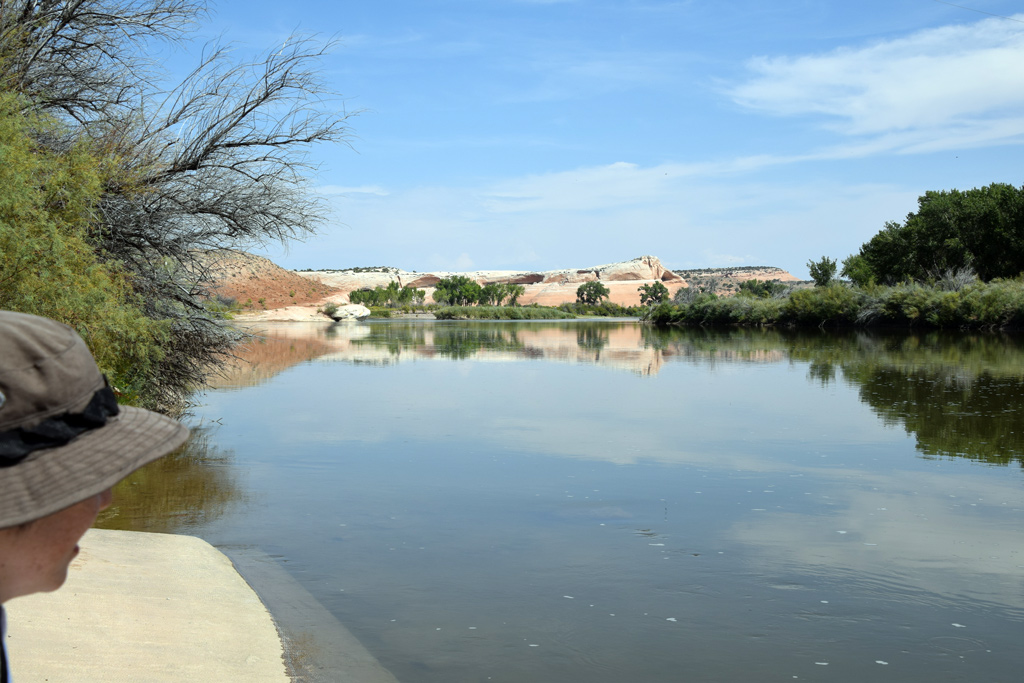 : Colorado River at Cisco Landing
Residents of Cisco practically relied their water supply on Denver & Rio Grande Western Railroad[1]. The railroad supplied the water since the establishment of the town and to the 50s.
The source of the culinary water was the Colorado River about four miles east of the town. The epic water supply system named “Cisco Pipe Line” installed by the railroad in 1883 is well represented in the ICC Valuation Map drawn in 1919 and revised in 1927[2]. According to the Map, Pump H’se No. 25, Coal H’se No. 28, Pumper’s Dwg No. 26 and W.C. No.27 at Cisco Landing, two concrete reservoirs on the hill, a water tank at Cisco, and the 6" steel pipe connecting the facilities formed the system.
Successive operators and sometimes his family resided by the pump house. Found in the Census and newspapers are:
Charles Edward Johns(1855 – 1931) in 1900. Charles U. Hallett(1881 – 1942), Edward K. Holbrook(1854 – ?), and Samuel S. Roberts(1859 – 1930) in 1905. Edward Daniel Stone(1866 – ?) in 1907. Walter Scott Dayton(1874 – ?) in 1910. Henry Hansen(1860 – 1932) in 1913. Perl Claud in 1914. Martin Tifus in 1917. John Callahan and Joseph Killian in 1920. R. Wissler and Frank Hall in 1921. Neil Maurice Carswell(1902 - 1966), and Louis H. Redmon in 1932. Roscoe Clarence Hallett(1890 – ?) in 1940.
Albert J. May(1890 – 1973) of Green River used to take care of water systems at Cisco, Thompson, Green River, and Cedar before his retirement in 1960[3].
A few ranchers/farmers such as the Augusta Devine family and Ernest E. Campbell family along the Colorado River were their neighbors[4]. A schoolhouse was built at Campbell Ranch[5].
Unfortunately, however, the railroad abandoned the system in 1955[6]. The steel water tank at Cisco was removed in September 1958, along with the tank at Thompson[7, 8, 9]. Pumper’s Dwg No. 26 and W.C. No.27 at the south of Pump H’se No. 25 were retired in preceding 1939 according to ICC Valuation Map. Pump H’se No. 25 itself was demolished in the 60s. The rest is left in the terrain. Here are the photos of the remainder:
All photos were taken on Sep. 10, 2017, except for special remarks.
Pump House [1st]
 : BLM historical marker
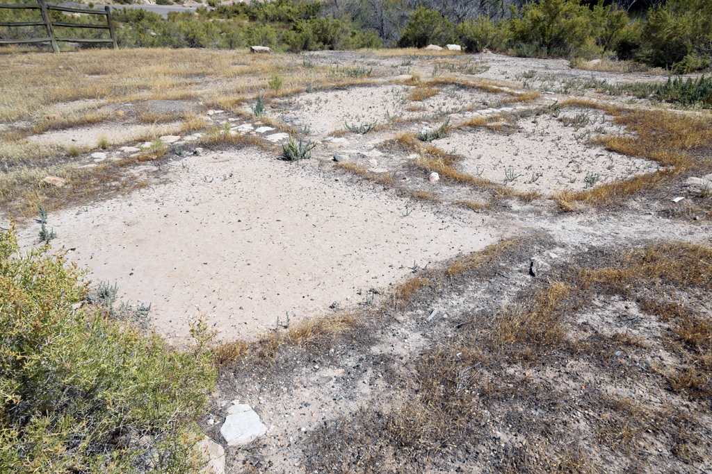 : foundation of a structure
 : 1952 USGS aerial photo of the site
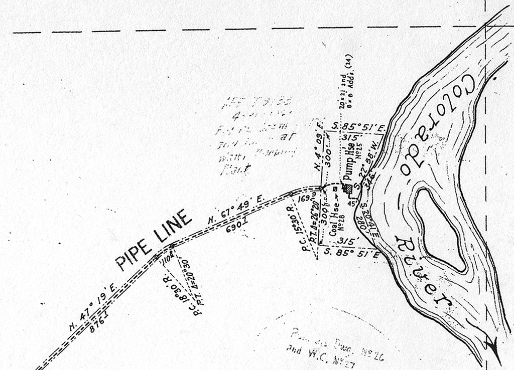 : 1919 ICC Valuation Map
 : May 1,1960 photo by Jim Ozment
 : pump house interior at Gato[10]
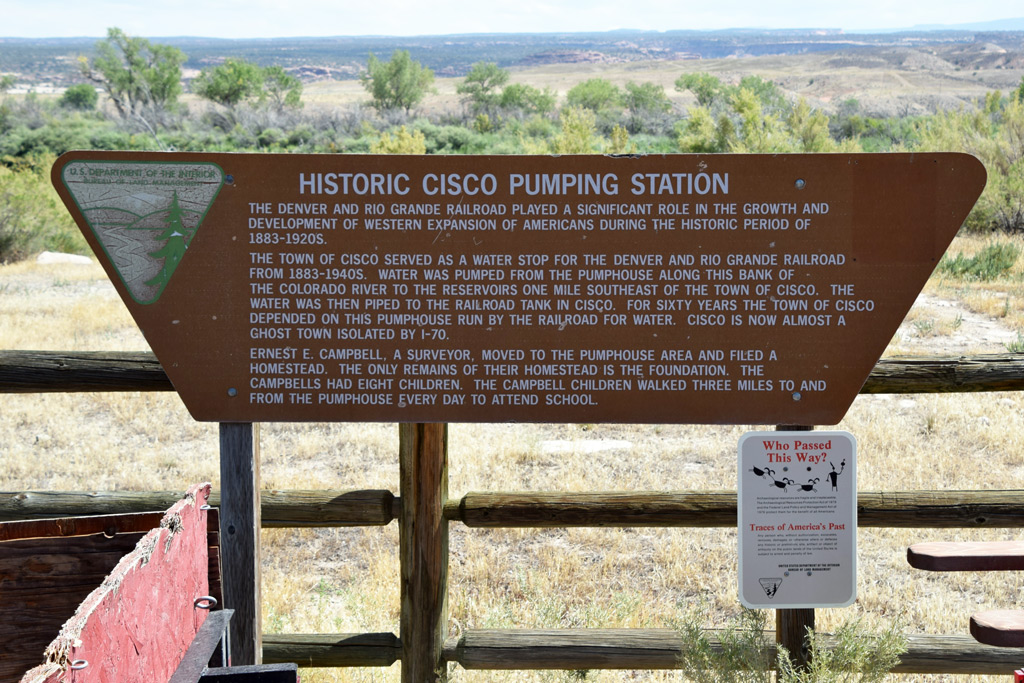
A foundation of a structure is preserved at Cisco Landing.
The BLM marker in front of the remains describes this as the remains of Ernest Elisha Campbell, Sr (1867 – 1937) homestead. But, according to the land patent, his homestead is filed about three miles south of Cisco Landing[11]. Moreover, the site this foundation lies in is within the D&RG property marked in the 1919 ICC Valuation Map. Accordingly, I believe this remains as the foundation of Pump H’se No. 25 represented in the ICC Map.
Represented above for reference is the interior photo of the pump house at Gato, Colorado[10]. The wall made of stone is the point in common. The boiler of the former narrow-gauge Utah & Pleasant Valley Railway locomotive #1 was initially reused to power the pump at Cisco[12].
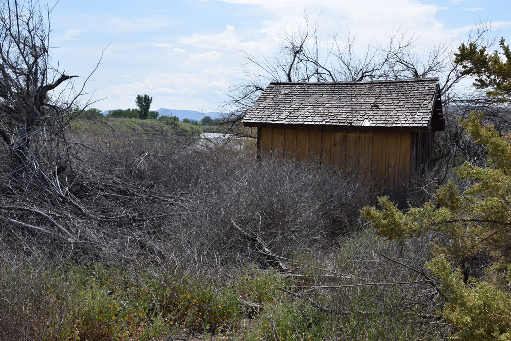
Pump House [2nd]
 : pump house exterior
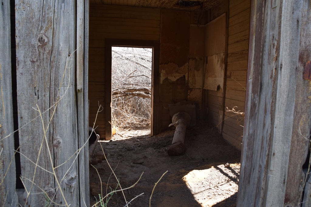 : smoke stack lying inside
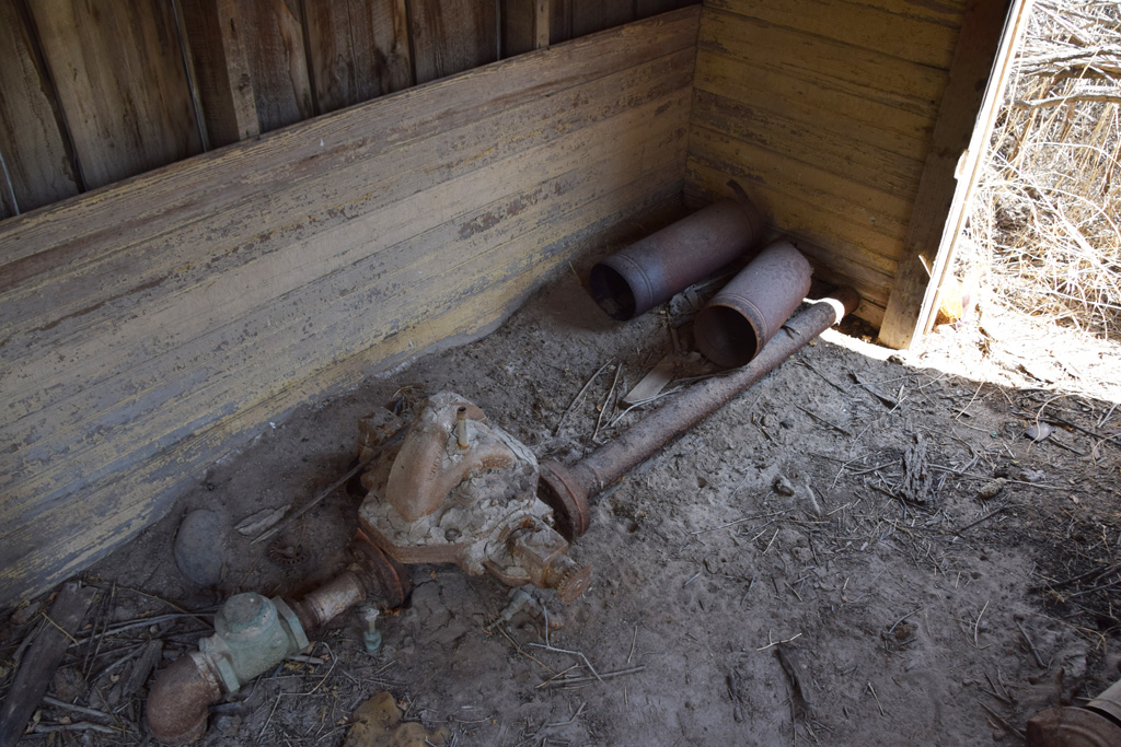 : remains of the plumbing
This little frame structure with a gabled wood shingle roof still stands on the bank of the Colorado River. The structure must have been built when the fuel for the pump was changed from coal to natural gas or gasoline[13]. The entire system seems rebuilt in the 20s[14, 15]. Inside the structure remain an exhaust pipe and pump/plumbing.
revised, Jan. 18, 2018
revised, Aug. 17, 2018
revised, Nov. 2, 2018
revised, Feb. 7, 2021
revised, Mar. 29, 2023
[1] arx (2015) "Rio Grande as a Lifeline – Water Supply at Cisco", Boxcar Red Collection;
[2] Denver & Rio Grande Railroad Colorado/Utah Stateline to Green River, UT ICC Valuation Maps, Colorado Railroad Museum
[3] Feb. 1, 1973 Times-Independent;
[4] Bennett, Lee A., (2009) A History of Selected Ranches on a Twenty-mile Stretch of the Colorado River in Grand County, Utah. Bennett Management Services, LLC
[5] Nov. 1, 1923 Times-Independent;
[6] Mar. 10, 1955 Times-Independent;
[7] Ozment, James (1958) "Charlie Moore Cutting On Water Tank", Sep. 30, 1958, WesternRailImages.com;
[8] Oct. 16, 1958 Times-Independent;
[9] Ozment, James (1958) water tank @ Cisco, UT;
[10] Farnsworth, Vince (2015) "Pagosa Junction Surprise", Farnsworth Scenics;
[11] Campbell homestead entry map;
[12] Strack, Don, (2011) Utah & Pleasant Valley Railway Locomotives, UtahRails.net;
[13] Oct. 15, 1923 Times-Independent;
[14] Jan. 11, 1923 Times Independent;
[15] Jul. 26, 1928 Times Independent;
 : Cisco Pipe Line system map
2017-12-01 09:00
コメント(0)
Water Supply at Cisco, Part 3 [Column_Cisco Range]
Residents of Cisco practically relied their water supply on Denver & Rio Grande Western Railroad[1]. The railroad supplied the water since the establishment of the town and to the 50s. Unfortunately, however, the railroad abandoned the system in 1955[2]. Here are the photos of the remainder:
Reservoirs
 : the town of Cisco appears far left
 : 6” pipe, maybe an overflow, sticking out from the foreground bank
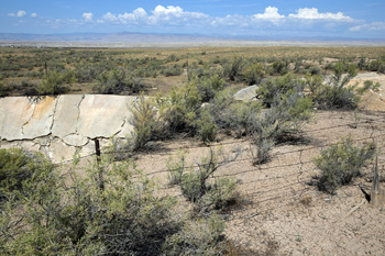
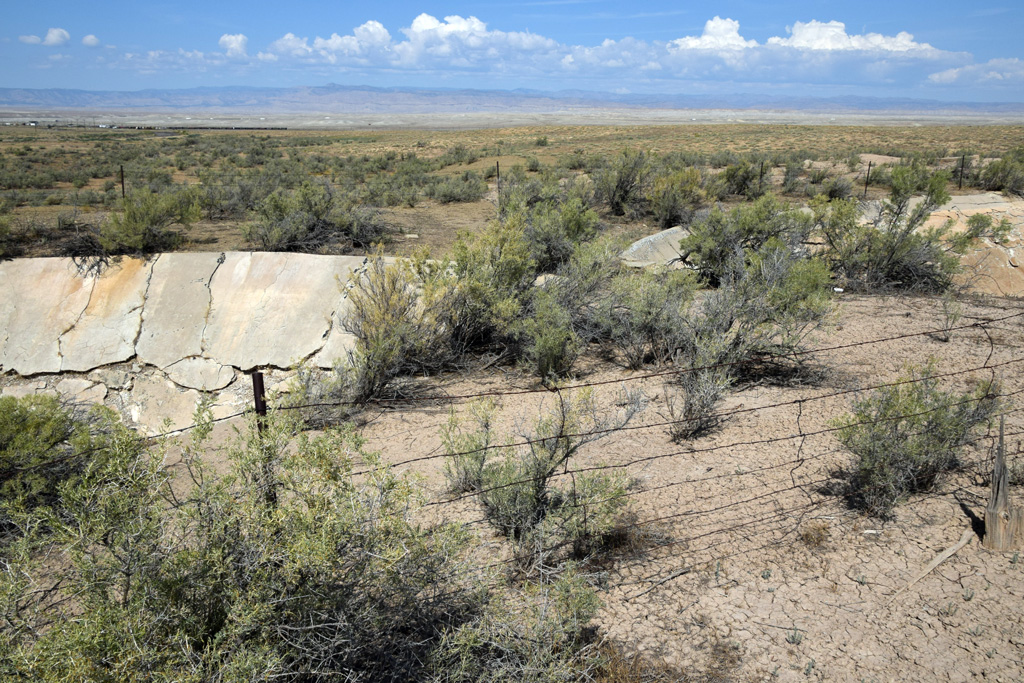
The reservoirs were constructed on the hill at the highest point between Cisco Landing and Cisco, about a mile east of the town. According to the 1919 ICC Valuation Map, two almond-shaped concrete reservoirs had a capacity of 400,000 gallons each.
The pipeline would run through between two reservoirs guarded by the barbed wire fence. But the south side reservoir was out of order by the time of abolition[2].
All photos were taken on Sep. 10, 2017, except for special remarks.
Steel Water Tank
 : Sep. 30, 1958 photo by Jim Ozment
The original wood water tanks which stood next to the depot were replaced by the 100,000-gallon steel water tank opposite the depot in 1928: Stearns-Rogers Construction Co. of Denver was the contructor[3, 4]. The steel tank was retired in 1955 and dismantled in Sep. 1958[5, 6]. It seems an old tank car with a hand pump was buried between the depot and the signal maintainer's house as the drinking water reserver.
The photos below are of the former Rio Grande water tank at Thompson, which was also dismantled and moved in 1958[7]. The shed next to the former Thompson tank seems also a Rio Grande heritage.
To maintain the whole water system, the railroad stationed the bulldozer B-2 at Cisco[8].
[1] arx (2015) "Rio Grande as a Lifeline – Water Supply at Cisco", Boxcar Red Collection;
[2] Mar. 10, 1955 Times Independent;
[3] Jun. 7, 1928 Times Independent;
[4] Jul. 19, 1928 Times Independent;
[5] Mar. 10, 1955 Times Independent;
[6] Ozment, James (1958) water tank @ Cisco, UT;
[7] Oct. 16, 1958 Times Independent;
[8] Awards of the Second Division, National Railroad Adjustment Board, with an Appendix, Vol. IX, U.S. Government Printing Office;
: Cisco Pipe Line system map
Reservoirs
 : the town of Cisco appears far left
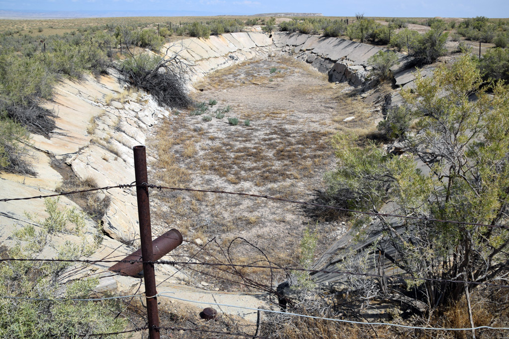 : 6” pipe, maybe an overflow, sticking out from the foreground bank
The reservoirs were constructed on the hill at the highest point between Cisco Landing and Cisco, about a mile east of the town. According to the 1919 ICC Valuation Map, two almond-shaped concrete reservoirs had a capacity of 400,000 gallons each.
The pipeline would run through between two reservoirs guarded by the barbed wire fence. But the south side reservoir was out of order by the time of abolition[2].
All photos were taken on Sep. 10, 2017, except for special remarks.
Steel Water Tank
 : Sep. 30, 1958 photo by Jim Ozment
The original wood water tanks which stood next to the depot were replaced by the 100,000-gallon steel water tank opposite the depot in 1928: Stearns-Rogers Construction Co. of Denver was the contructor[3, 4]. The steel tank was retired in 1955 and dismantled in Sep. 1958[5, 6]. It seems an old tank car with a hand pump was buried between the depot and the signal maintainer's house as the drinking water reserver.
The photos below are of the former Rio Grande water tank at Thompson, which was also dismantled and moved in 1958[7]. The shed next to the former Thompson tank seems also a Rio Grande heritage.
To maintain the whole water system, the railroad stationed the bulldozer B-2 at Cisco[8].
revised, May 1, 2022
revised, Mar. 29, 2023
[1] arx (2015) "Rio Grande as a Lifeline – Water Supply at Cisco", Boxcar Red Collection;
[2] Mar. 10, 1955 Times Independent;
[3] Jun. 7, 1928 Times Independent;
[4] Jul. 19, 1928 Times Independent;
[5] Mar. 10, 1955 Times Independent;
[6] Ozment, James (1958) water tank @ Cisco, UT;
[7] Oct. 16, 1958 Times Independent;
[8] Awards of the Second Division, National Railroad Adjustment Board, with an Appendix, Vol. IX, U.S. Government Printing Office;

 : Cisco Pipe Line system map
2017-12-08 09:00
コメント(0)
Highway Bridges Surrounding Cisco [Column_Cisco Range]
 : Nash Wash, Hwy and the Bridge in 1971 movie “Vanishing Point” still
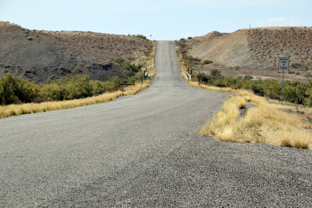 : Cisco Wash, Hwy and the Bridge
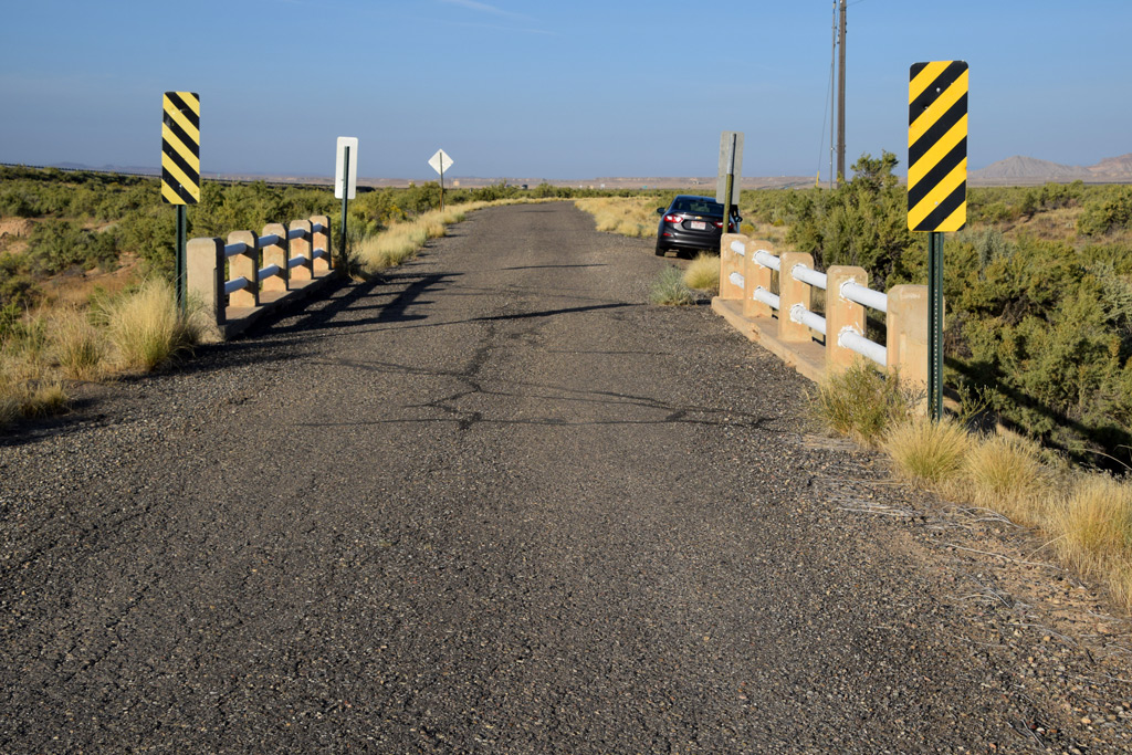
The town of Cisco is guarded by washes from both directions, east, and west: Danish Wash lies on the east and Cisco Wash lies on the west.
After the designation of US Hwy 50, the conventional Midland Trail through Cisco was reconstructed in 1931[1]. The new bridges spanning the washes were constructed at the same time, therewith freed Cisco from isolation.
But, when a rezoning of Cisco to a heavy Industrial use was planned time after time since the 80s, the ages and the weight limits of the bridges on old US Hwy 50 & 6 were always one of the concerns[2]. Accordingly, it can be said that these bridges ironically have been contributed to the isolating of Cisco against the economic wave.
Here, I introduce those vintage highway bridges found near Cisco, one each from periods respectively:
All photos were taken on Sep. 10, 2017
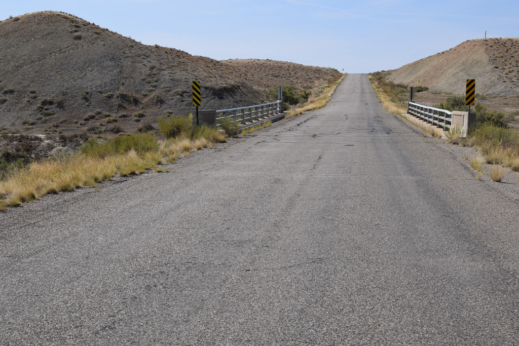

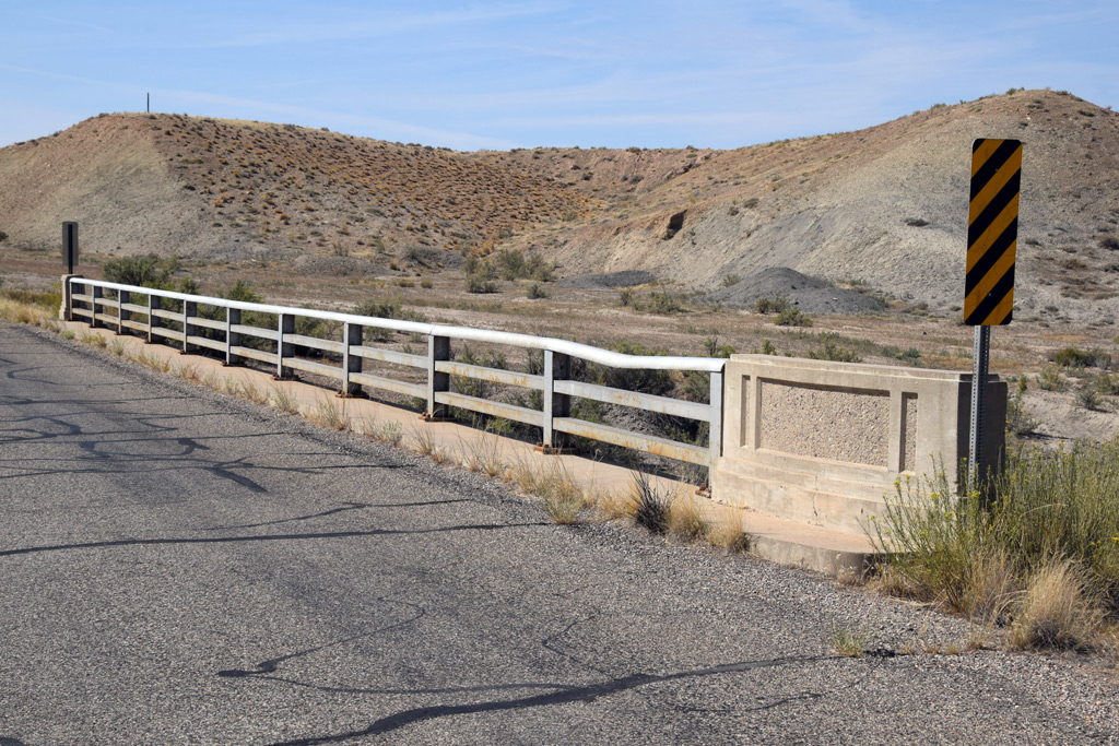
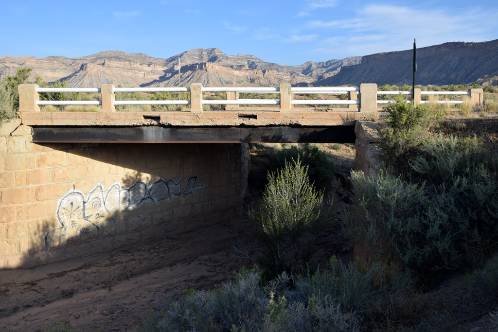
Cisco Wash Bridge was built in 1949 with concrete rigid frame, to replace the old bridge built when US Hwy 50 was constructed[3]. Its longest span is 82.0 ft. and width of the deck is 26.2 ft[4]. 2012 Google street view shows weight limit of 30 tons on road sign attached to it. But it was reduced to only 11 tons when I visited in 2017.

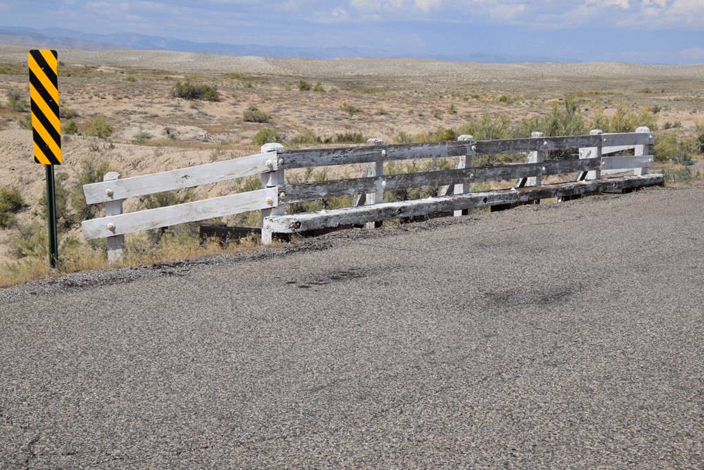
Danish Wash Trib 3 Bridge was built in 1931 with steel stringer. Its longest span is 25.9 ft. and width of the deck is 24.0 ft[5]. It has weight limit of 18 tons according to the road sign attached to it.
 : 1930 Conoco road map
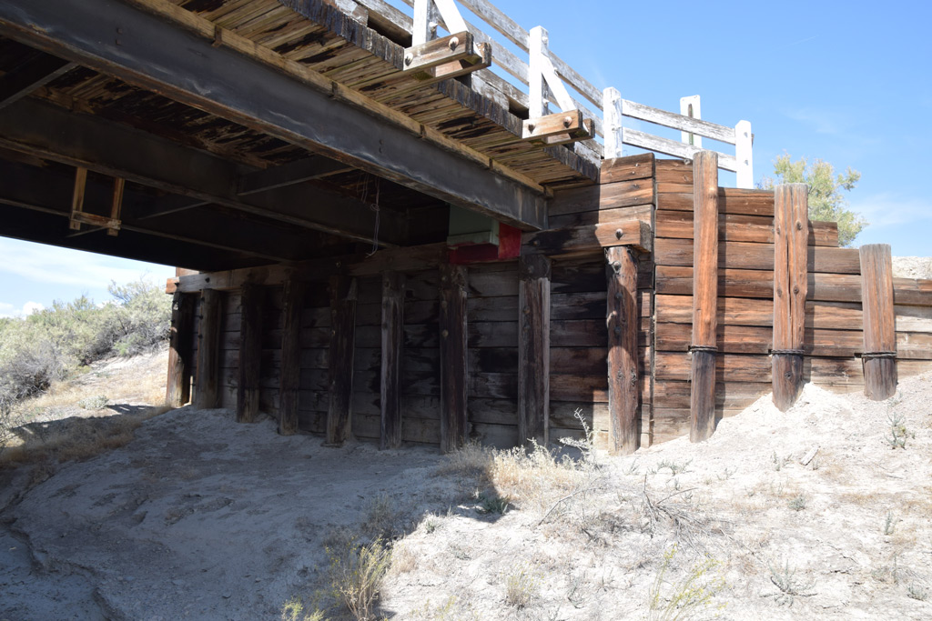
Thompson Wash Bridge on old Valley City Road was built in 1919 with steel stringer. Its longest span is 28.9 ft. and width of the deck is 16.1 ft[6]. The road sign attached to it says "LEGAL LOADS ONLY".
This bridge seems the oldest surviving highway bridge still in use in this region: the oldest seems the burnt Dewey Bridge built in 1916[7]. Valley City Road is the remnant of Midland Trail/US Hwy 50 between Thompson and the now evaporated Valley City, designated at least until 1933[8, 9]. Accordingly, this section of the road and the bridge tells us how the Midland Trail was in its heyday.
[1] Apr. 30, 1931 Times-Independent;
[2] Jul. 16, 2009 Times-Independent;
[3] Nov. 27, 1941 Times-Independent;
[4] Bridgehunter.com webpage for Cisco Wash Bridge;
[5] Bridgehunter.com webpage for Danish Wash Trib 3 Bridge;
[6] Bridgehunter.com webpage for Thompson Wash Bridge;
[7] Bridgehunter.com webpage for Dewey Bridge;
[8] Dec. 28, 1933 Times-Independent;
[9] Sanderson, Dale (2003) "Historic US Highway ends in and near Crescent Jct, UT" mapguy;
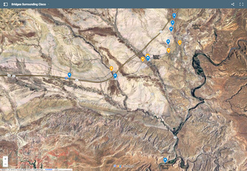 : map of bridges around Cisco
2018-02-09 09:00
コメント(0)
Japanese at Cisco [Column_Cisco Range]
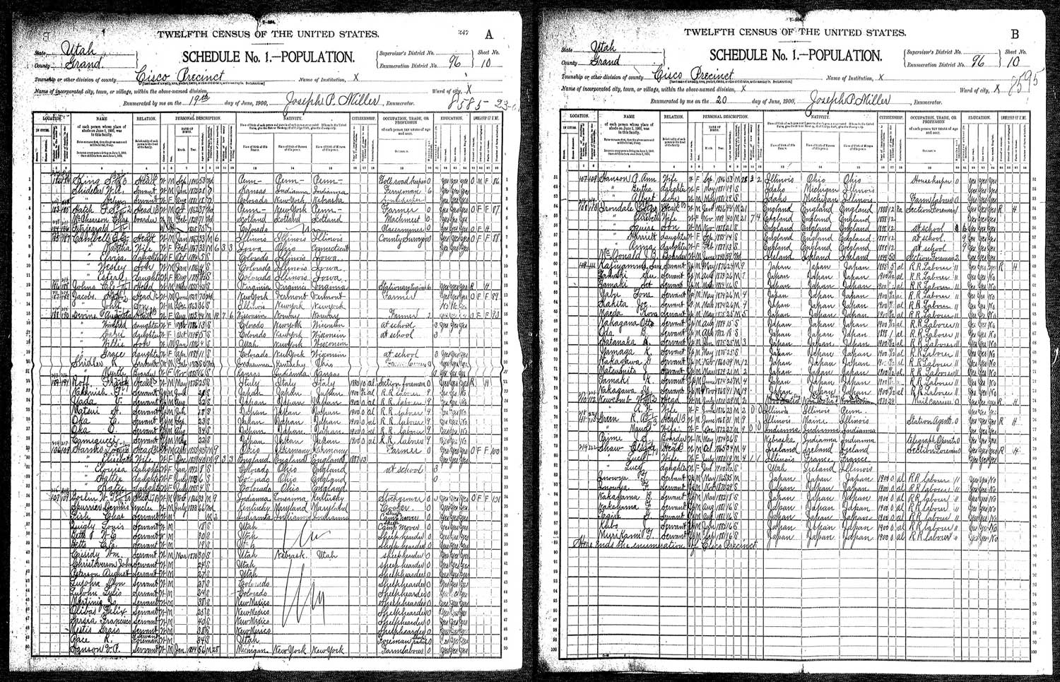 : the 1900 Census of Cisco
As we can read on the hood of UP locomotives, the word “build” seems more suitable than “find” for the American continent. According to the Trains News Wire, Chinese railroad workers who worked for building Central Pacific Railroad were inducted into the Labor Hall of Honor in 2014[1]. Here, in Cisco, we can also find the footprints of immigrant workers who helped build America.
According to the Topaz Museum Revised Interpretive Text, some 275000 Japanese immigrants arrived in the United States between 1885 and 1924. The 1910 Census recorded 2110 Japanese living in Utah, mostly in Salt Lake City and Ogden, working as farmers, miners, and on the railroad[2]. The 1900 Census, the first complete Census available for Cisco, recorded 89 people in the town. Among them, 27 immigrated males from Japan are listed as RR section hands. The youngest among them was fifteen years old at that time. The names listed are;
K. Hatanaka (畠中[presumed family name in kanji]、born in Japan, Jan 1875),
F. Inowya (probably Inoue. 井上、Japan, Nov 1870),
T. Inowya (probably Inoue. 井上、Japan, May 1865),
Sam Kajiyamma (probably Kajiyama. 梶山、Japan, May 1876),
Joe Kakita (柿田、Japan, Mar 1874)
J. Kubo (久保、Japan, Jan 1882),
H. Matsui (松井、Japan, Jan 1882),
J. Matsumito (probably Matsumoto. 松本、Japan, Mar 1879),
Kom Maeda (前田、Japan, May 1875),
T. Murikami (probably Murakami. 村上、Japan, Sep 1881),
G. Nakagawa (中川、Japan, Nov 1860),
Y. Nakagawa (中川、Japan, Nov 1868),
Otto Nakagawa (中川、Japan, Aug 1884),
T. Nakanishi (中西、Japan, Jun 1879),
B. Nakayama (中山、Japan, Mar 1882),
F. Nakayama (中山、Japan, Aug 1881),
B. Oda (小田、Japan, Apr 1882),
O. Oka (岡、Japan, Aug 1866),
T. Oka (岡、Japan, Sep 1877),
G. Tagire (田切、Japan, Aug 1881),
K. Tamaki (玉置、Japan, Jun 1874),
Ku Tamaki (玉置、Japan, Aug 1875),
Set Tamaki (玉置、Japan, Mar 1884),
Tanigucci (probably Taniguchi. 谷口、Japan, May 1878),
Tom Yabu (藪、Japan, May 1874),
V. Yada (矢田、Japan, Aug 1878),
K Yamaga (山家、Japan, May 1875).
Accompanied are four immigrant Section Foremen:
John Irondale (born in England, Jan 1856).
J. B. McDonald (Ireland, Jun 1840),
Frank Roff (Italy, May 1875),
Clyde Shaw (Ireland, Oct 1865).
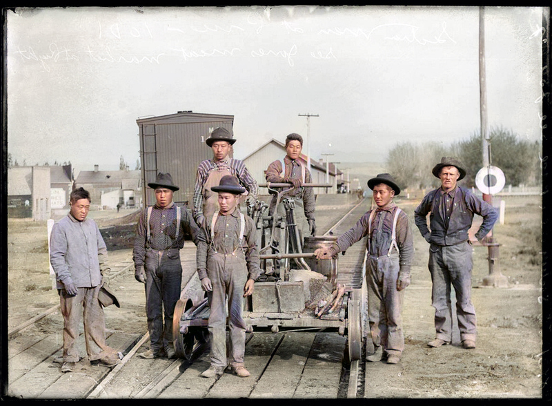 : section gang photographed at Price, Utah. Courtesy, L. Tom Perry Special Collections, Harold B. Lee Library,
Brigham Young University
: section gang photographed at Price, Utah. Courtesy, L. Tom Perry Special Collections, Harold B. Lee Library,
Brigham Young UniversityYozo Hashimoto(橋本養蔵, 1851 – 1914), a Japanese immigrant, established a labor agency in Salt Lake City in the 1870s, later followed by his nephew Edward Daigoro Hashimoto(橋本大五郎, 1875 – 1936) of E.D. Hashimoto Company founded in 1902[3, 4]. Hashimotos recruited Japanese immigrants to provide section hands for the Rio Grande and Western Pacific[5, 7]. Accordingly, these Japanese immigrants recorded at Cisco must have been sent to the section by Hashimotos.
Notice that everyone in the colorized photo above wears blue jeans: Levi Strauss began selling denim with suspender buttons in the 1870s. Hashimotos provided them Japanese food, rice, and clothes and sent their wages to Japan[5]. Though daily necessities were provided, the section gangs might have been forced to live in boxcars or tents, as the Census shows no marks of them owning or renting a home.
The railroad construction through Grand County was begun in 1881. According to the book Grand Memories, by then, most of the track gangs were Japanese and Chinese[6]. However, the construction was completed in 1883. Also, the relocating and standardizing of the mainline through Cisco was completed in 1890. Accordingly, the Japanese section gangs recorded in the 1900 Census might rather be maintained or constructed additional facilities than built the way.
1910 Census of Cisco records none of these section gangs. They might have been moved to another section. I’m moved as not only am I Japanese but there is the same family name with me on the list.
Newspaper clips below show the activities of Japanese immigrants:
Advertisement of E.D. Hashimoto recruiting D&RG gang on May 22, 1905 The Japanese American
Advertisement of the Oriental Construction Co. recruiting D&RG gang at Grand Junction on Nov. 29, 1912 The Colo-Shinbun
Season's Greetings message by the Japanese D&RG gang at Helper and Soldier Summit on Jan. 1, 1920 The Utah Nippo
 : May 22, 1905 The Japanese American
 : Nov. 29, 1912 The Colo-Shinbun
 : Jan. 1, 1920 The Utah Nippo
Here is another story of the Japanese at Cisco.
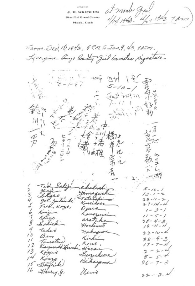
On January 11, 1943, sixteen Japanese-American males were pulled into the by-then abandoned Dalton Wells Civilian Conservation Corps camp, located about 27 miles southwest of Cisco[8].
In total, more than 50 Japanese-American males were incarcerated here called Moab Isolation Center. But they were transferred to Leupp, Arizona on April 27 of the same year, due to the camp’s harsh environments[9].
The first sixteen Japanese-American males left signatures in Japanese on a sheet dated April 14, 1943, as listed below[10]:
Ichiji Ted Akaboshi (signature in Japanese・赤星一次)
Geiji Yamaguchi (山口源二)
Shigetoshi Sam Tateishi (立石茂敏)
Yoshisuke Joseph(Gil) Kurihara (栗原好助)
Kozo Fred Ogura (小倉幸三)
Kinji Kurozumi (黒住謹示?)
Keizo Arataka (荒崇敬三)
Sokichi Harry Hashimoto (橋本宗吉)
Tadao Nakagawa (中川忠雄)
Toshikazu Ben Kishi (貴志敏一)
Tamotsu Tommy Kono (河野保)
Hiroshi Raynard Hirai (ヒライヒロシ)
Kazuo Suzukawa (鈴川一男)
Kinzo Wakayama (若山金藏)
Shigeishi ? (?)
Yoshio Harry Ueno (上野義雄)
The rest are listed below[11];
Kumiharu Frank Ego
Masakazu Frank Fukuichi
Kameichi Fukumoto
Teruyoshi Harada
Tsutomu Higashi
Hiroshi Engaku
Nobuo Hiraoka
Masao Henry Imahara
Shigeyoshi Victor Inouye
Mitsuo Kaida
Yoshiro Kazu
Seio Kamamori
Hiroshi Kamiya
Masuo Kanno
Masao Kawate
Ichiji Kimura
Kinoe Kiyama
Masaharu Dick Kodani
Naoji Bill Kuga
Wataru Jack Makihara
Saburo Frank Marubashi
Kazuto Masumoto
Tatsuo Bob Matsuda
Kameichi Matsumoto
Kazume Tom Mizuno
Mamoru Yoshi Morishige
Kiyoji Nakamura
Nimashi Oishi
Minoru Otsuka
Yoshio Saika
Ichiro Roy Sato
Yoshiichi Shibanaka
Kentaro Takatsui
Kenji Bill Tanabe
Masataka Tanabe
Masaaki Tanaka
Masashi Mike Tanimoto
Koichi Bill Tsuji
Minoru Tsuji
Tsutomu Umezu
Yoshimasa Uno
Jyoji Geroge Yamashiro
Hoshio Yamato
Yukio Roy Yokome
revised, May 27, 2022
revised, Apr. 28, 2023
revised, Jan. 12, 2024
[1] May 9, 2014 Trains News Wire;
[2] Topaz Museum Revised Interpretive Text;
[3] Papanikolas, Helen Z., Kasai, Alice, (1976) Japanese Life in Utah, Utah History to Go
[4] Taniguchi, Nancy J., (1994) Japanese Immigrants in Utah, Utah History Encyclopedia
[5] Bradley, Martha S., (2000) The Changing Face of Faith, Heterotopolis, Association of Collegiate Schools of Architecture;
[6] Daughters of Utah pioneers, (1972) Grand Memories, Utah Publishing Company
[7] Crouse, Lorraine, (2016) Building Tracks to New Beginnings: Japanese Railroad Workers in the West, J. Willard Marriott Library Blog, The University of Utah;
[8] Firmage, Richard A., (1996) A History of Grand County, Utah State Historical Society
[9] Utah Division of State History web page
[10] Louthan, Bruce D., (1993) "Moab Japanese-American Isolation Center", Vol. 19, Canyon Legacy, Dan O'Laurie Museum of Moab
[11] Moab Museum Insatagram;
 : Harry Y. Ueno Papers, JARP, UCLA
 2019-09-27 09:00
コメント(0)
Cisco at a Glance by the 17th Census [Column_Cisco Range]
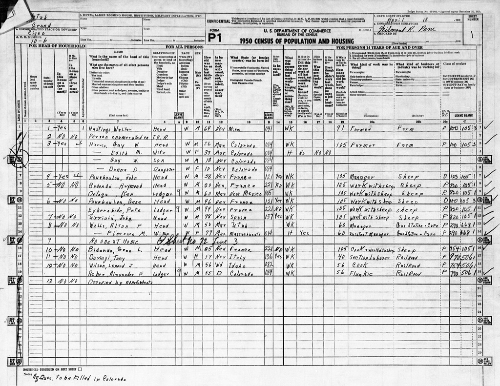 : first sheet of 1950 Census
The US Censuses are disclosed 72 years after they are taken. The 17th Census was released in April of this year.
As for Enumeration District (E. D.) 10-6, which includes the town of Cisco, it was enumerated by the later Thompson postmistress Wilmont Rosanna "Winnie" Wolverton Pene(1924–1985) between April 18 and 26, 1950. It lists 99 persons in 59 dwellings. The population of this District declined to below one hundred after three decades.
Let me show how the town and the "Ciscoites"[1] was in April 1950;
Many French, maybe Basque, herders who don’t appear in the 1940 Census are enumerated in the northern or eastern suburbs of the town. Most of the railroad section hands, probably living in the outfit sleepers, became Hispanic. While Japanese gangs which dominated the 1900 Census are long gone.
The last Westwater postmistress Velda Lorraine "Babe" Kelly Bittle (1907–1988) and her family are enumerated in this District; the Westwater Post Office is to close in 1954.
The other located residents enumerated outside Cisco are: farmer Arthur Allen Brusch (1893–1968) and his wife at Westwater, farmer Louis Edward Decrow (1888–1968) and his wife, farmer Carl Wilbur Decrow (1916–1966) and his family at Fitzpatrick Ranch in the Book Cliffs, farmer Frank Shields (1896–1983) and his wife at Picture Gallery, and farmer John William Dalton (1883–1961) and his wife at Dewey.
The easternmost business along the US Highway 50 & 6 in this Enumeration District is the gas station and cafe operated by Alton Fordham (1896–1968) and Florence May Pickett(1901–1958) Wells at Harley Dome.
The following business along the highway appears is the brand-new gas service station and garage(Census serial number of Dwelling unit 29), aka Cisco Automotive Service, operated by Elton Richard and Mary Aeline Cowger at the east entrance of the town. Hereafter, see the link for the details if it has a link. Next to the west is the general mercantile and gas station(30), aka Capansky’s Bar, Restaurant and Gas Station, operated by William Boston and Eppie Nettice Capansky since 1934.
Dorothy Hammond Morris Haskins (1885–1975) is the agent and telegrapher at the railroad depot(37) since 1947 according to the June 12, 1947, Times-Independent. Railroad signal maintainer’s house(36) constructed in 1944, aka Seely House, is occupied by William J. Hawley Seely, his wife Carolyn, and their two children.
The section house(34) on the east side of the depot is occupied by the railroad section hand Lucilo Aguilera (1906 − 1999), his wife Marie "Lena", and their three children. Another section house(38), maybe a boxcar, on the west side of the depot is occupied by the railroad section hand Lebrado "Lee" Carbajal (1912−2001), his wife Cecilia, their four daughters, and also a lodger from Mexico named Pilar "Pete" F. Carbajal (1905−1976). Pete, his wife Juanita "Jenny", and their three children later lived in a boxcar on the north side of the railroad track near the water tank. However, any section foreman or pump operator, enumerated in the previous Census, isn’t enumerated this time.
John William and Edger Malcolm Burke brothers succeeded the cafe and cabins(40), aka Ruth's 66 Cafe, from Victor Kirby Murray in 1948 and are operating it as Burke Cafe. William Richard and Mattie Gertrude Cowger are operating the store, cafe, gas station, and cabin, aka Cisco Mercantile, since 1944. They are living in the house(50) behind the Mercantile. The post office(51) next to the Mercantile to the west is managed by Henrietta Marie "Hattie" Girard Fuller since 1933. Her two children are with her. The post office seems to be the westernmost business in the town at this time.
Along 2nd Street, State road maintenance attendant Harry Ballard Harris is living in the house(39) behind the Cisco mercantile with his wife Wava and two children. Not enumerated, but a Lee Carbajal relative and a railroad section hand, Monico Aguilera (1904−1978) is living with his wife Louse "Lucy" and six children in a house next to Harris' on the south. Also not enumerated, but a miner John B. Miller (1904−1954) is living with his wife Lorene and their two children in a house next to Harris' on the west. Lorene is the daughter of Virginia Gruver.
A railroad section hand Manuel D. Vigil (1881−1951) is living in the house(46) behind the Capansky's with his two children. The teacher's house(48) opposite Vigil's is occupied by a "nonresident", must be the Cisco School teacher at that time, Edwinna McFarland (1883−1964). Hidden Owl Ranch operator Klair Black Carroll (1923−2015), his wife Addie, and their three children are living in the house(47) opposite the post office today. Howard Jean Kimmerle (1913−1991), his wife Myrna, and their three children were the predecessor[2].
Accordingly, 38 persons reside in 12 dwellings at Cisco. That brings 61 persons to scatter around in the surrounding wilderness.
The completion of another service station, the completion of the railroad signal maintainer’s house, and the moving out of Cisco Hotel/the completion of Cisco Motel are significant changes in downtown Cisco, compared to the 1940 Census information.
For more, the former Cisco Automotive Service operator Mary Aeline Lewis Cowger Hepperle (1919−2016) describes her memories of Cisco in the early 50s in the 2004 magazine Vol. 51 of Canyon Legacy. The 1952 USGS aerial photo also shows how downtown Cisco was in the early 50s.
revised, Oct. 25, 2022
[1] the common name of Cisco area residents used in newspapers;
[2] June 26, 1947 Times Independent;
* Official 1950 Census Website;
 : 1952 USGS aerial photo
2022-09-23 09:00
コメント(0)
Cisco at a Glance by the 12th Census [Column_Cisco Range]
: the 1900 Census of CiscoWe verified the 17th Census in the previous post. I decided to go back further in time, to see how the town of Cisco emerged, through the successive Census records. The US Censuses are generally disclosed 72 years after they are taken. But, the 12th Census was released a year later in 1973. This is the oldest Census record of Cisco available today.
As for Cisco, it was enumerated by Joseph Philip Miller (1870−1929) of Moab between June 19 and 20, 1900. 88 persons in 16 dwellings are enumerated in Enumeration District (E.D.) 96.
Most of the residents reside along the Grand/Colorado River upstream from Dewey where a ferry operated to cross the river.
The toll road between Moab and Cisco along the River is to be completed in 1902 by Samuel N. King (1846−1913). King and servants William Andrew and Helen Shideler reside in King's home(Census Dwelling Number 206) at Dewey. Shidelers are the later Cisco Hotel proprietor. Farmer Franz Seigal Hatch (1862−1939) and a boarder reside in Hatch's home(207) at Cottonwood Bend Ranch at Dewey.
Placer miner John Fitzgerald (1842−?) resides in his own home(208) located somewhere between Dewey and Cisco landing.
County surveyor Ernest Elisha Campbell (1837−1937), his wife, his two daughters, and his son reside in his own home(209) at Hidden Owl Ranch, stationary engineer/pumper Charles Edward Johns (1855−1931) occupies the pump house(210), and farmer Augusta Hanson Devine (1857−1938), her three daughters, her son, a servant, and a boarder reside in Devine's home(212) at Bobcat Ranch, all at Cisco Landing.
Farmer Horatio Howard Jacobs (1829−1909) and his son reside in his own home(211) at Westwater. Denver & Rio Grande Western Railroad section foreman Frank Fedele Garofalo Roff (1874−1955) and six Japanese servants occupy the section house(213) probably at Westwater.
Farmer Louis Harms (1855−1947), his wife, and his three daughters reside in his own home(214), and stock grower Walter Thomas Goslen (1866−1940), his uncle, his 15 servants, and families reside in Goslen's home(215) upstream of Cottonwood Wash at the foot of the Book Mountains/Cliffs. One of the servants enumerated is Victor Putman Hanson (1841−1920) who will patent the Cisco townsite in 1910.
Railroad section foreman Franklin Clyde Shaw (1879−1961), his wife, his daughter, and seven Japanese servants occupy the section house (or bunk cars concerning the number of persons)(219) probably located at Whitehouse.
Several railroad workers and their families are enumerated in the town of Cisco.
Section foreman John Arrandale (1856−1918), his wife, his son, his two daughters, a boarder who is also a foreman, and 14 Japanese servants occupy the section house (or bunk cars concerning the number of persons)(216). Agent Robert Allen Green (1868−1922), his wife, and a boarder who is a telegraph operator occupy the depot(218). The agent also holds the post of postmaster. Mail carrier William North Newcomb (1870−1926) and his wife reside in a rented home(217) probably located near the depot.
Accordingly, 25 persons reside in 3 dwellings at Cisco. That brings 63 persons to scatter around in the surrounding wilderness.
A decade since the relocation of railroad tracks and Cisco station, all but railroad facilities seem to conquer the wilderness according to the Census. But, the school was established, the hotel opposite the depot operated by the agent got an extension, a grocery store was opened by George Washington Sadler (1864−1921) of Richardson, and a feed store was built by James Milton Waring (1854−1946) of Moab, all in 1898. The town was emerging.
My previous post mentions the Japanese railroad workers enumerated at Cisco. Little-known place names around Cisco are shown in Google Maps below.
: Historical place names around Cisco
2023-06-02 09:00
コメント(0)
Cisco at a Glance by the 13th Census [Column_Cisco Range]
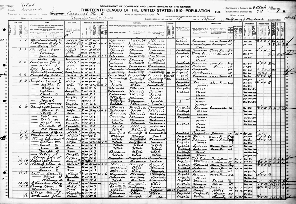 : first sheet of 1910 Census
The US Censuses are disclosed 72 years after they are taken. The 13th Census was released in 1982.
As for Cisco, it was enumerated by Eugene Montgomery Moreland (1858−1931) of Cisco between April 15 and 26, 1910. 232 persons in 90 dwellings are enumerated in Enumeration District (E.D.) 49.
Relatively many sheepmen, miners/prospectors, laborers, and sometimes their families scatter around at unidentified places in the surrounding wilderness: 58 sheepmen, 6 miners, and 7 laborers, most of them probably reside in tents, are enumerated in the Census.
Regarding the permanent residents, several farmers settle at the foot of the Book Mountains/Cliffs extended at the northernmost of the E.D.
Farmer William Francis May (1877−1947) reside in his own home(Census “visitation number” of location 63) at Book Mountains/Cliffs, and farmer David Monroe Burkenbine (1874−1930), his wife, his adopted daughter, and a boarder reside in a rented home(64) at the upstream of Cottonwood Wash.
Farm accountant/manager Charles Keller Ritzman (1867−1941) and his wife reside in a rented home(59), and freighter Frank Sewell (1888−1960), and two lodgers reside in a rented home(60), both probably located in the area.
The community of Westwater along the Grand/Colorado River is not included in this E.D. at 1910 Census.
At the upstream of Coates Creek near the Utah/Colorado border locates the community of Picture Gallery. Farmer Miles Humphrey (1845−1921) and his wife reside in his own home(4), farmer James Harrison Campbell (1869−1955), his wife, his son, and his five daughters reside in his own home(6) both at Picture Gallery. Carpenter Alfred Simpson (1842−?) resides in a rented home(7) probably also at Picture Gallery.
East of Cisco townsite along the Grand/Colorado River locates the community of Cisco Landing/Pumphouse.
Farmer Augusta Hanson Devine (1857−1938), her daughter, and her son reside in her own home(12), and farmer Chole Hallett (1858−1940) and her two sons reside in her own home(11), both at Bobcat Ranch.
Farmer/pumper Edward Earnest Stone (1866−1945), his wife, his two sons, his daughter, and a lodger reside in Stone's home(9), and stationary engineer/pumper James "Johney" Saferight (1883−1935) reside in his own home(10) both at Pumphouse.
Farmer Asa Knowles (1837−1917), his son, his daughter, and his grandson reside in his own home(2) at Knowles Ranch opposite the river at Pumphouse.
Near Cisco Landing along Agate Wash, Marrs Land and Development Company begin constructing irrigation facilities to attract homesteaders. Accordingly, 38 construction workers, relatives, and their families reside in the area.
Beside them, accountant/postmaster George Mohr (1883−1945) and his brother reside in his own home/post office(16), lumber dealer Mathias Striegel (1852−1910) and his son reside in his own home(17), mason Riley P. Shideler (1848−1921) resides in his own home(13), carpenter Hugh McCarten (1886−?) resides in his own home(15), and stock grower Walter Simpson Squier (1876−1936), his wife, and his daughter reside in his own home(28), all in Marrs area.
South of Cisco landing along the Grand River locate several ranches. Farmer Alfred W. Morse (1859−1931) resides in his own home(8), and farmer Ernest Elisha Campbell (1867−1937), his three sons, and his three daughters reside in his own home(5), both at Hidden Owl Ranch.
Farmer Eugene Montgomery Moreland (1858−1931), a housekeeper, and a ward reside in Moreland's home(1) probably at Coates Creek, and farmer John James Anderson (1855−1929), his son, a boarder, and his hired man reside in Anderson's home(3) at Hotel Bottom.
South of Cisco townsite along the Grand River locates the community of Dewey.
Farmer Charles P. Bovard (1856−1915) and a partner reside in Bovard's home(81) at Gordon Ranch located near Dewey.
Farmer Frank Seigal Hatch (1862−1919) and teacher Albert Ray Brown (1880−1968) as a boarder reside in Hatch's home(86) at Cottonwood Bend Ranch in Dewey.
farmer/miner/county sheriff Richard Dallin Westwood (1863−1929), his wife, his five daughters, and two sons reside in a rented home(87) at Cato Reclaim in Dewey.
Blacksmith Quintus Cato (1857−1930), his wife, his two sons, and his daughter reside in his own home(84) at Dewey.
Emily Carolyn Wells May (1857−1911) and her son reside in a rented home(82), mail carrier Marion Othello Mott (1892−1958) resides in a rented home(83), and farm hand Christopher H. Nave (1877−?) resides in a rented home(89), all probably at Dewey.
Farmer Ernest Mountstephen Vine (1857−1920) and his wife reside in his own home(75), and farm hand William M. Neff (1862−?) resides in a rented home(76), both at an unidentified place in the area.
Within the Cisco townsite, several businesses are thriving toward coming takeovers.
Cisco Mercantile and Cisco Hotel proprietor Victor Putman Hanson (1841−1920), his wife, a servant, a boarder, and his hired man reside in Hanson's home/hotel(37). His wife is a laundry, and his servant is a cook at the Cisco Hotel.
Miner William Andrew Shideler (1872−1939), his wife, his son, and his daughter reside in his own home(29). He will take over Cisco Hotel in 1911.
Farm laborer/Cisco Times editor George Everett Atkinson (1876−?) and carpet salesman James Guyn McBride (1879−1968) as a lodger reside in Atkinson's home(32). James will take over Cisco Mercantile in 1918.
Postmaster Albert Lewis Hanson (1881−1977) resides in his own home/post office(38).
Laborer Henry Hansen (1860−1932) and his wife reside in a rented home(36). He will take over as the postmaster in 1919.
Boarding house housekeeper Frank Alpaugh (1884−1960) and his wife reside in his own boarding house(90) probably located within Cisco townsite.
Along the Denver & Rio Grande Western Railroad tracks, several railroad workers and their families occupy the facilities next to Cisco townsite.
Agent James Issac Rounds (1865−1945) and his wife occupy the depot(34), and telegraph operators Charles Edward McMullin (1885−1959) and Robert N. Cook (1888−?) occupy the telegrapher’s bungalow(35).
Section foreman John L. Smith (1875−1936), his wife, his son, and his daughter, and section hand Laurence R. Brisant (1888−?), his wife, and his daughter occupy the section house(33), and section hand James Theros (1887−?), two boarders, and a cook occupy the bunkhouse(39).
Section hand Lloyd Orville Roberts (1889−1918) resides in a rented home(49), and bridge work teamster Herman Beckmon Lynch (1863−?) resides in a rented home(40), both probably located within Cisco townsite.
Accordingly, 33 persons reside in 12 dwellings in the town of Cisco. That brings 199 persons to scatter around in the surrounding wilderness.
Five years after the establishment of his Cisco Mercantile and Cisco Hotel, V. P. Hanson patented the Cisco townsite this year maybe to adjust the sprouting private structures and properties. The growing community will soon attract the telephone line.
Little-known place names around Cisco are shown in Google Maps below.
: Historical place names around Cisco
2023-06-30 09:00
コメント(0)
Cisco at a Glance by the 14th Census [Column_Cisco Range]
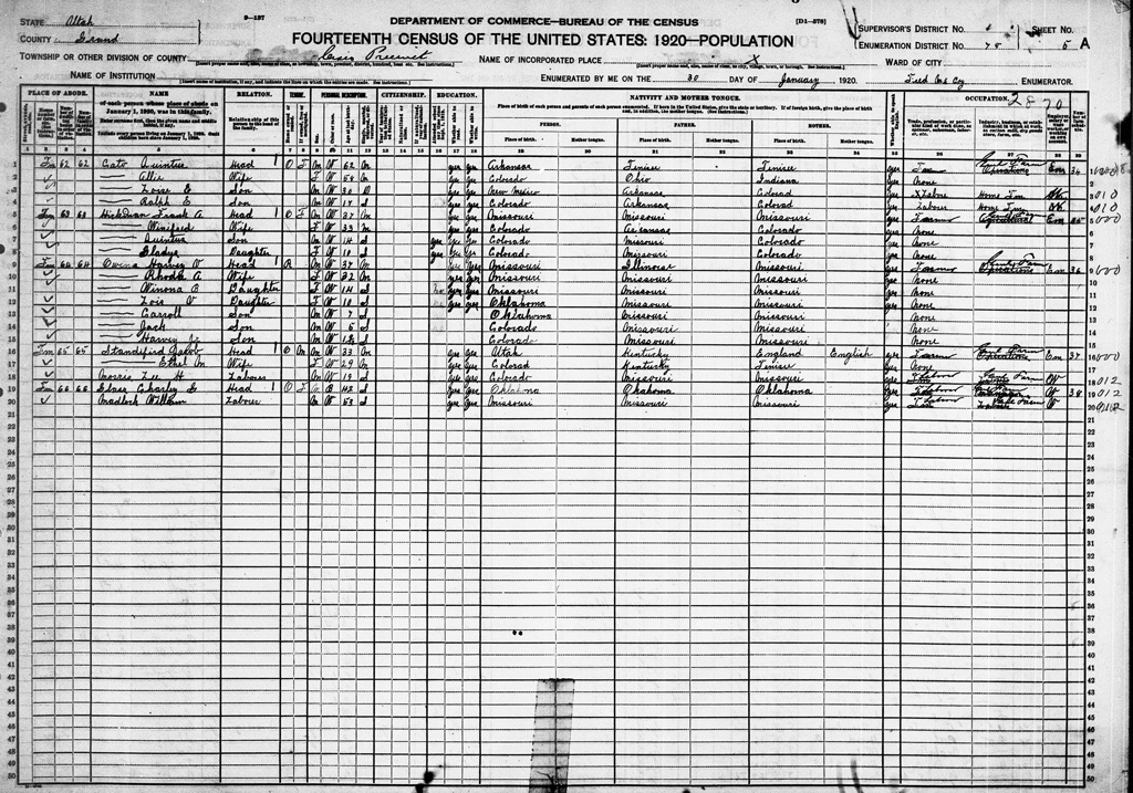 : first sheet of 1920 Census
The US Censuses are disclosed 72 years after they are taken. The 14th Census was released in 1992.
As for Cisco, it was enumerated by prospector/miner Fred McCoy (1868−1945) of Castleton between January 30 and February 2, 1920. 95 persons in 26 dwellings are enumerated in Enumeration District (E.D.) 10-6.
56 persons in 14 dwellings are enumerated outside the Cisco townsite.
Several ranch farmers and their families reside at the foot of Book Mountains/Cliffs north of the Cisco townsite.
Stock rancher Harvey Valentine Owens (1882−1959), his wife, his two daughters, and his two sons reside in a rented home(Census “number of dwelling house” 64), and stock farm laborers Charles Glass (1878−1937) and a boarder reside in Glass' home(66), both at Turner Ranch.
Several farmers and their families reside at Danish Flats north of Cisco townsite.
Farmer Quintus Cato (1857−1930), his wife, and his two sons reside in his own home(62). He was the first settler to homestead in the Danish Flats area. By Jan. 1920, farmer Frank Absolum Hickman (1881−1969), his wife who is a daughter of Quintus Cato, his son, and his daughter reside in his own home(63), farmer Jacob Henry Standifird (1886−1977), his wife, and a boarder reside in Standifird's home(65), and sheep grower Pete Patten (1885−?) and his wife reside in a rented home(79), all at Danish Flats.
Hendrix families reside at Coates Creek located southeast of Cisco townsite at the east bank of Grand/Colorado Liver. Teamster John Milford Hendrix (1884−1959) and his mother reside in a rented home(80), and farmer Thomas Henry Hendrix (1877−1956) and his son reside in another rented home(81).
Several stockmen reside at unidentified places outside the Cisco townsite.
Stock laborer Frank L. Poris (1885−?) and sheep laborer Joseph P. Martin (1884−?) reside in a rented home(85), sheep foreman Perfecto Mearin (1885−?) and seven sheepherders reside in a rented home(86), and sheep grower Albert A. Glenn (1872−1933) and four sheepherders reside in a rented home(87).
Several railroad workers and their families reside at Westwater station east of Cisco townsite. Section foreman John Willard Dowell (1869−1937), his wife, and his four sons occupy the section house(76), and section hand, later Whitehouse foreman, Abedon B. Sanchez (1892−1932) and his wife occupy the bunkhouse(75)[1].
Several railroad workers and their families reside at Whitehouse station located west of Cisco townsite. Section foreman David Samuel King (1867−1941), his wife, his daughter, and his son occupy the section house(70), section hand Lorenzo Smith King (1895−1968), his wife, and his daughter occupy a bunkhouse(71), and section hand Earl Herman Dahling (1890−1967), his wife, his daughter, and his son occupy another bunkhouse(72)[2].
39 persons in 12 dwellings are enumerated in the town of Cisco.
Cisco Mercantile co-proprietor James Guyn McBride (1879−1968), his wife, and his three daughters reside in his own home(67) behind the Mercantile, and the Cisco Mercantile co-proprietor Douglas Morton McBride (1886−1977), his wife, and his daughter reside in his own home(68) also behind the Mercantile.
Postmaster Henry Hansen (1860−1932) and his wife reside in his own home/post office(69).
Hotel proprietor Dean L. Edwards (1874−?), his daughter, cook, cook's wife, cook's daughter, cook's son, and pool hall proprietor Riley P. Shideler (1848−1921) reside in the hotel(77). Riley’s son mail contractor William Andrew Shideler (1872−1939), his wife, his son, his two daughters, his sister-in-law, and his mother-in-law reside in his own home(78).
Along the Denver & Rio Grande Western Railroad tracks, several railroad workers and their families reside in the railroad facilities. Agent/operator Charles W. Johnston (1898−?) occupies the depot(73). Telegraph operator Marie C. Cooper (1891−?) and her mother occupy the telegrapher’s bungalow(74). Section foreman Louis Demarco (1878−1931), his wife, his two daughters, and his son occupy the section house(84)[3]. Section hands Vern Lewis (1877−?) and Filepe Alonse (1880−?) reside in a bunkhouse(82), and section hand Gustacio Delgado (1874−?) resides in another bunkhouse(83).
A decade after the establishment of the Cisco townsite, the businesses at Cisco steadily grew: Pace Brothers Company was established in 1913, Riley Shideler expanded his Cisco Hotel in 1917, and the post office escaped from the railroad depot and dominated next to the Hotel in 1919. Midland Trail completed in 1913 also drew roadside businesses to the town.
[1] Jan. 18, 1923 Times Independent;
[2] Dec. 16, 1920 Times Independent;
[3] Mar. 25, 1931 Daily Sentinel;
: 1919 ICC valuation map, courtesy of Utah State Archives2023-09-08 09:00
コメント(0)
Cisco at a Glance by the 15th Census [Column_Cisco Range]
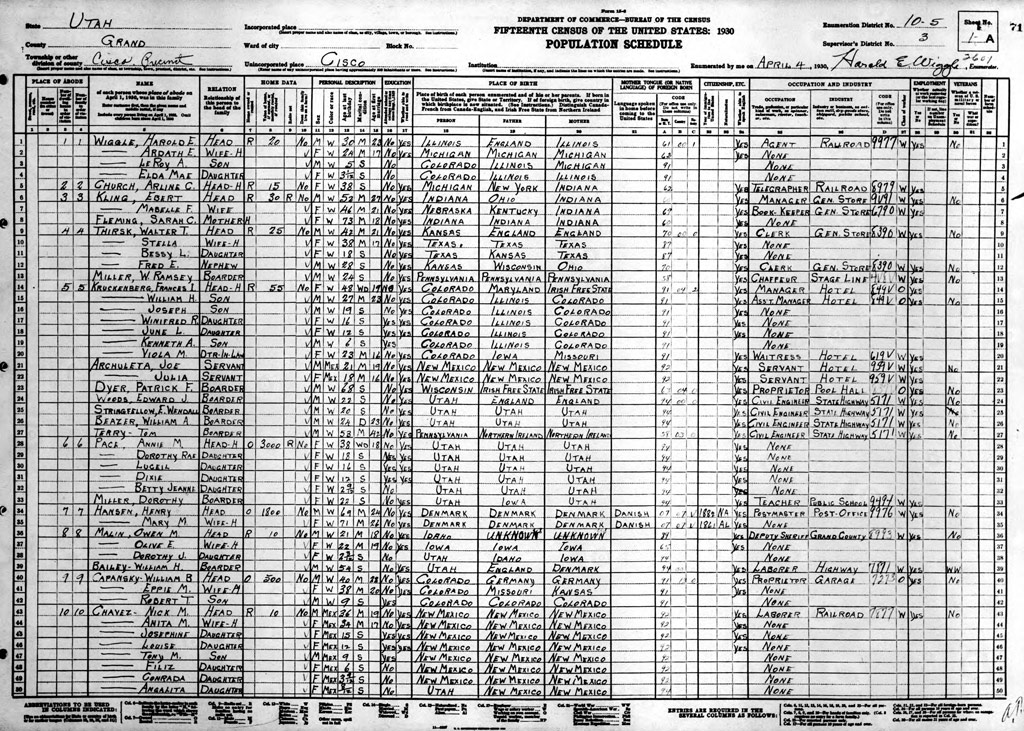 : first sheet of 1930 Census
The US Censuses are disclosed 72 years after they are taken. The 15th Census was released in 2002.
As for Cisco, it was enumerated by railroad agent Harold Ethelbert Wiggle (1900−1941) and town electrician Louis Elsa Cato (1889−1972) between April 4 and 26, 1930. It lists 193 persons in 45+2 dwellings (+2 caused by disorders of Census “number of dwelling house in order of visitation”).
84 persons in 24+2 dwellings including three tents are enumerated outside the Cisco townsite.
Northernmost of the Enumeration District (E.D.) 10-5, the Greater Cisco Field of gas and oil spreads in the northern half of the Cisco Desert. Several companies have been digging wells in the area since its discovery in 1923. 1930 Census enumerates several well workers in the area.
Gas well laborer Hermon E.White (1889−1963), his wife, his daughter, his six sons, and a boarder who is a miner, gas well laborer Richard Alexander Speaks (1908−1957), his wife, his three sons, and his daughter, gas well laborer Walter Raymond Oglesby (1902−1988), his wife, his three sons, and his daughter, gas well laborer Kenneth lawrence Towsley (1901−1993), his wife, and his three sons, and gas well laborer William Russell Payne (1898−1964) reside in each rented home(“number of dwelling house in order of visitation” 1, 2, 3, 7, 11). Truck driver Guy A. Miller (1889−1948), his wife, and his daughter reside in a rented home(3.5).
Within the Greater Cisco Field, farmer Hans Joseph Erickson (1874−1949) and his wife, who are one of the first settlers of Danish Flats, reside in his own home(28). Farmer Herman C. Rowe (1878−?) also resides in his own home(27) at this area.
Sheepherders and cattle stockmen are contesting over the grazing lands in the Book Mountains/Cliffs ranges north of the gas & oil field.
sheepherder Claude Raimes Blanchard (1876−1938), Rufo Eisogvirre (1900−?), and Joe Zubizarrita (1891−1978) reside in each tent(4, 5, 6), and sheepherder Frank Zabla (1895−?) reside in a rented home(10).
Turner Ranch ranch hand Eugenia Turner Jones (1868−1943), her son, her daughter, her son-in-law, and well-known black cowboy Charles Glass (1878−1937) as a boarder reside in Jone's home(9). Another Turner Ranch ranch hand Byron Theodore Smith (1904−1989) and his wife reside in a rented home(29). Ranch proprietor Albert James Turner (1886−1946) resides in his own home(26).
Easternmost of this E.D. along the Colorado River and the Denver & Rio Grande Western Railroad locates the community of Westwater. Several farmers reside there. Stockmen Ira Dominic Weimer (1895−1985), and his wife, Edgar Earnest Larsen (1907−1970), his wife, his daughter, his son, and his father, and Raymond Lester McBeth (1898−1981) and his wife reside in each home(8, 12, 13). Sheepherder Visnta Rosas (1900−?), and two boarders who are sheep camp laborers reside in a rented home(16). And farmer Awltmer Leslie Tomlinson (1880−1941), his wife, his three sons, and his six daughters reside in a rented home(14).
At the east of the Cisco townsite along the Colorado River aka Cisco Landing reside several farmer families and a pumper family. Farmer Charles Ulric Hallett (1881−1942), his brother who is a pumper, and his mother reside in a home(22A), farm laborer John W. Wadoll (1878−?) resides in a rented home(21), farmer Emery Knowles (1870−1952), his wife, his son, and his daughter, farmer Robert Lafayette Armstrong (1888−1957), his wife, and his three sons, farmer Alfred W. Morse (1859−1931), and farmer Walter Lee Wood (1872−1948), his wife, his three sons, his two daughters, and a boarder who is a farm laborer reside in each home(22, 23, 24, 25).
109 persons in 21 dwellings are enumerated within the Cisco townsite.
Easternmost of the townsite, garage(9) proprietor William Boston Capansky (1887−1951), his wife, and his son reside in his own home.
Cisco Hotel(5) manager Frances Isabelle Kruckenberg (1880−1960), her three sons, her two daughters, and her daughter-in-law, servant, servant's wife, pool hall proprietor Patrick Franklin Dyer (1861−1936), and four civil engineers reside in the hotel.
Cisco Hotel co-proprietor Sireno H. Puyales (1884−1957), cook, and two railroad section hands and a farm laborer as boarders reside in a rented home(15).
Rancher/Cisco Hotel co-proprietor John Alonzo Johnston (1881−1969), his wife, his son, and his daughter-in-law reside in a rented home(14).
Cisco Mercantile manager Ebert Kling (1878−1948), his wife, and his mother, clerk Walter Thomas Thirsk (1887−1933), his wife, his daughter, and his nephew reside in each rented home(3, 4).
Annie E. Pace (1870−1955), her four daughters, and Cisco School teacher Dorothy Miller (1908−2003) reside in Pace's home(6) probably behind the Mercantile. Annie is the wife of Pace brothers Co. co-founder John Ezra Pace (1867−1957).
Postmaster Henry Hansen (1860−1932) and his wife reside in his own home/post office(7) next to the mercantile.
Boarding house proprietor Virginia Gruver (1898−1978), her two sons, her two daughters, and a cattle laborer as a boarder reside in the boarding house(19) behind the post office.
Deputy sheriff Owen Maddox Malin (1908−1984), his wife, his daughter, and a boarder, electrician Louis Elsa Cato (1889−1972), his wife, and his two daughters, and farm laborer Herbert Elwin Johnston (1902−1994), his wife, and his daughter reside in each rented home(8, 11, 15) within Cisco townsite.
Sheep shearing plant proprietor Joseph Maria Ocamica Barainca (1893−1980), his wife, his son, two boarders who are ranch laborers, and a servant reside in Ocamica's home(16) probably located at the north of railroad tracks: the plant was located at the north of the tracks.
Hotel proprietor Pia Gandarillas (1890−?), her daughter, cook, and two boarders who are miners reside in the hotel(17) probably located north of the tracks.
Oil well laborer Frank Parker Moore (1901−1954) resides in a rented home(18) probably located north of the tracks: his late father was a coal passer.
Along the Denver & Rio Grande Western Railroad tracks facing the townsite, several facilities are occupied by the railroad workers and their families.
Railroad agent Harold Ethelbert Wiggle (1900−1941), his wife, his son, and his daughter occupy the depot(1).
Telegrapher Arline Chonita Church (1888−1973) occupies the operator’s bungalow(2).
Section foreman Jesus Rodriguez (1899−?), his wife, his son, his step-son, his two step-daughters, and two boarders who are also section hands occupy the section house(13).
Section hand Nicholas M. Chavez (1894−1974), his wife, five daughters, and his son, section hand Rafael L. Pando (1897−?), his wife, two sons, and four boarders who are also section hands occupy each bunk houses(10, 20). Section hand Manuel D. Vigil (1881−1951), his wife, his three daughters, and a boarder who is also a section hand reside in a rented home(12) behind the later Duke’s Service facilities.
Amid the Great Depression and Prohibition, Cisco boasted a population of nearly two hundred thanks to the gas well operation. The town got the gas line in 1923. The new post office was also erected in 1923. The railroad’s water supply system was renovated and the tank at the town changed from wood to steel in 1928. Cisco was still in action.
For more, historian Mike Milligan describes the history of Westwater into the 30s in the 2004 magazine Vol. 51 of Canyon Legacy. The 1937 UtahStateGS aerial photo also shows how downtown Cisco was in the 30s.
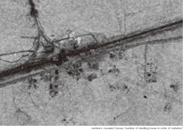 : 1937 UtahStateGS aerial photo
2023-10-06 09:00
コメント(0)
Cisco at a Glance by the 16th Census [Column_Cisco Range]
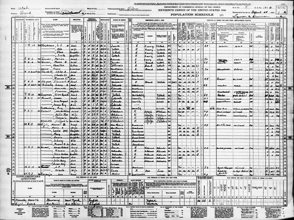 : first sheet of 1940 Census
The US Censuses are disclosed 72 years after they are taken. The 16th Census was released in 2012.
As for Cisco, it was enumerated by later county attorney Lyman Elvin Duncan (1913−1999) between April 28 and 30, 1940. It lists 248 persons in 49+1 dwellings, including temporal 109 persons in 12 dwellings of railroad section gang (+1 means a family is enumerated without the “number of Household in order of visitation”).
Northernmost of the Enumeration District (E.D. 10-6) at the foot of Book Mountains/Cliffs reside several rancher families.
Rancher Ole Leo Johnson (1905−1944), his wife, his two sons, and his three daughters reside in a rented home, rancher Clarence Edwin Greer (1902−1967), his wife, his four daughters, and his two sons reside in a rented home, rancher Byron Theodore Smith (1904−1989), his wife, and a lodger reside in a rented home, and rancher Albert James Turner (1886−1946), his three sons, and his daughter reside in his own home, all located at in the area.
Easternmost of the E.D. along the Colorado River and the Denver & Rio Grande Western Railroad locates the community of Westwater. Several rancher families and railroad worker families reside in the area.
Rancher Alton E. Tomlinson (1906−1969), his wife, and his son reside in his own home, mechanic Leland Edward Francis (1904−1969) and his wife reside in a rented home, sheepherder Emmett Elizondo (1897−1992), his wife, and his son reside in his own home, merchant John Coleman Hardison (1874−1943) and his wife Killy who was the postmistress of Westwater Post Office reside in a rented home, ranch-hand Bernard Etcheverry (1895−1962), his wife, his two daughters, and his son reside in a rented home, ranch-hand Jay Edmund Belding (1904
−1989), his wife, his three daughters reside in a rented home, and ranch manager Pierre Pete Etcheverry (1893−1979), his wife, his son, and two lodgers reside in a rented home, all located at along the river probably from the upstream to downstream in order.
Railroad section foreman Pedro Perez (1896−?) and his wife occupy the section house, section hand Benny Alered Titus (1906−1990), his wife, and his son reside in his own home, section hand Manuel R. Valenzuela (1913−?), his wife, and his son reside in a rented home, and section hand Leonard Salatino (1883−1957) resides in a rented home located at in the area.
Denver & Rio Grande Western Railroad was relocating and extending the Cottonwood siding located at the west of Westwater in 1940[1]. 109 persons in 12 dwellings − probably outfit sleepers − of railroad section gang enumerated in the Census seems to set out for the work.
At the east of Cisco townsite along the Colorado River aka Cisco Landing reside several rancher families and a pumper family.
Rancher Louis James Christensen (1898−1957), his wife, and his two daughters reside in a rented home, rancher Marion Frederick Gruver (1888−1947) resides in a rented home, rancher Mason A. Greer (1899−1980) and his father reside in a rented home, and a sheepherder, Chole A. Martin Hallett (1858−1940), and her two pumper sons reside in her own home, and rancher Emery Knowles (1870−1952), his wife, and his daughter reside in his own home, all located at along the river probably from the upstream to downstream in order.
At the west of Cisco townsite along the Denver & Rio Grande Western Railroad locates Whitehouse station. Section hand Monico Aguilera (1904−1978), his wife, his two daughters, and his two sons may occupy the bunkhouse, and section foreman Frank Chiodo (1909−1992), his wife, and his daughter may occupy the section house.
Within the Cisco townsite reside several workers and their families.
Easternmost of the townsite, gas service station proprietor William Boston Capansky (1887−1951), his wife, and his son reside in his own station/home(Census Number of Household in order of visitation 14). Sirano Puyales Garcia (1884−1957), maybe the operator of the Duke's Service at that time, resides in his own home(15) next to it.
The mail carrier Ralph Dalton (1916−2002), his wife, and his son reside in a rented house(17) later became owned by John Maynard. Post mistress Henrietta “Hattie” Marie Girard Fuller (1888−1966), and her two sons reside in the “Federal Building”(20) consisted of the Post Office and the dwelling.
Behind the Post Office, Virginia Frances Paxton Gruver (1898−1978) and her two sons reside in her own boarding house(19).
Along Second Street, several residents reside in rented dwellings.
Railroad section hand Manuel D. Vigil (1881−1951), his wife, his three daughters, and his two sons reside in a rented home(10) behind Capansky's home. Opposite the Vigil's home, Cisco School teacher Elsie B. Jorgensen (1918−?) resides in a rented home(7) owned by State road foreman Victor Kirby Murray (1893−1962). He also owns the later Ruth Cafe, Cisco mercantile, and several rental dwellings at that time.
Railroad section hand Newell Arthur Taylor (1911−1967), his wife, and his daughter reside in a rented home(18) to the east of Vigil’s. Victor himself seems to reside in a rented home by the State Road Maintenance Station(21) facing the townsite with his mother. Maintenance Station truck driver Abner Edward Greer (1904−1992), his wife, his daughter, and his three sons also reside in a rented home(24) by the Station.
Along the railroad tracks facing the townsite, several facilities are occupied by the railroad workers and their families.
Agent Jeremiah Patrick Brennan (1900−1996), and his wife occupy the depot(12), and section foreman George Richard Burwell (1903−1962), his wife, his daughter, and his three sons occupy the section house(11). Compressor-man James Anton Mussatt (1913−2008), his wife, his son, and his father–in–law, section hand Walter Nelson Devault (1902−1984), his wife, his daughter, and his brother-in-law, and section hand Lebrado “Lee” Carbajal (1912−2001), his wife, his daughter, his son, and a lodger who is also a section hand occupy each bunkhouse(8, 9, 13). Section hand Elias Armigo (1912−?) and his mother, and telegrapher Arline Chonita Church (1888−1973), reside in each rented home(16, 22) within the townsite.
Accordingly, 56 persons reside in 17 dwellings at Cisco. That brings 192 persons including 109 railroad section gang to scatter around in the surrounding wilderness.
The designation of the US Highway 6 in 1937 brought several roadside businesses to Cisco in the 30s: buses began to operate between Denver and Salt Lake City, garage became service station, and hotel became motel. However, contrarily, the abolition of the Prohibition in 1933 seems to have brought some kind of decay to the “red light district” of Cisco; pool hall became cafe.
For more, the former Cisco resident Vonna Lucinda Foy Dalton (1921−2016) describes her memories of Cisco in the 40s in the 2004 magazine Vol. 51 of Canyon Legacy. The 1944 USGS aerial photo also shows how downtown Cisco was in the early 40s.
[1] Jul. 3, 1940 Daily Sentinel;
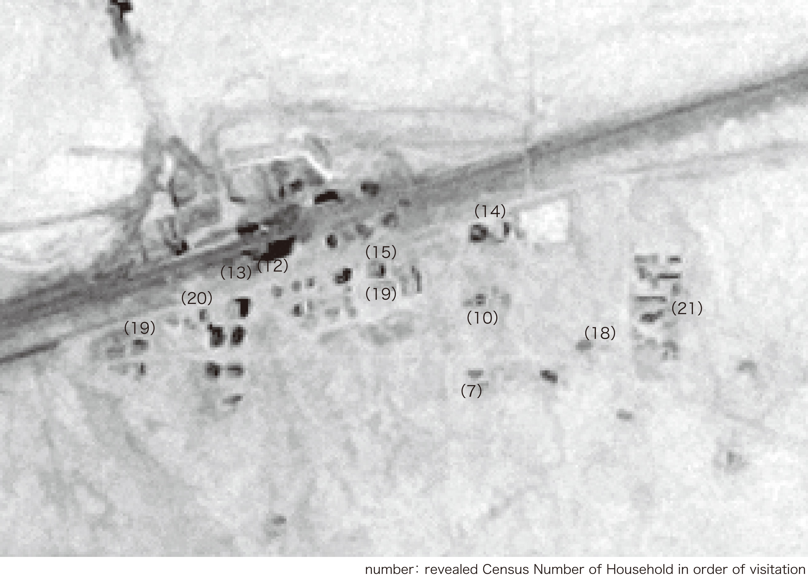 : 1944 USGS aerial photo
2023-11-03 09:00
コメント(0)
arx_Ph.D. さん
Here represented are my model railroad enthusiasm generated from the photos I took during my childhood at Knoxville, Tennessee, or from the photos I took during my recent trips.
I'm a retired professor of design, meanwhile a part-time associate at the architectural design office in Osaka, Japan where I live with my wife.


