Cisco Mercantile [Column_Cisco Townsite]
: site of Cisco Mercantile
I’m trying to duplicate the whole town of Cisco, Utah in N scale. This post introduces one of the structures in the town.
A few businesses survived along US Hwy 50 & 6 at Cisco in the early 70s; 4 gas service stations, a mercantile/cafe, and a motel. Some private houses also seem to exist along Second Street. Next to Ruth 66 Cafe on the west sat this structure on Lot 1 to 7 of Block 5, Cisco Townsite.
In the photo by John Barriger III taken no later than 1940, the west and north elevation of the structure are barely seen[1].
In the 1946 photo appeared in Canyon Legacy, a part of the south elevation of the structure is seen[2].
In the 1967 photo appeared in Gravity Base Station Network in Utah, the structure is barely seen[3].
In the 1969 photo appeared in Daily Sentinel, the north and east elevation of the structure are barely seen[4].
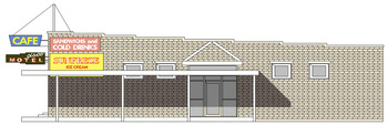
In the 1971 movie Vanishing Point, the upraised “Cisco MOTEL”, and “CAFE” neon signs, and the “SANDWICHES and COLD DRINKS” advertisement on the wall are seen.
In the book Helldorados, Ghosts and Camps of the Old Southwest, both the closed storefront and the east elevation of the structure are seen[5].
In the 1978 photo at the Flickr site, the closed storefront of the structure is clearly seen[6].
George Washington Sadler(1864 ー 1921) established a grocery at Cisco in 1898[7]. Moab merchant Hammond & Sons Company also had a branch store managed by Wallace Owen Knight(1879 ー 1958) which burnt to the ground on Aug. 8, 1904[8].
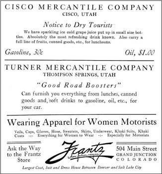
Victor Putman Hanson(1841 ー 1920) established the Cisco Mercantile Company in 1905[9]. Benjamin Harrison(1888 ー 1978) and Owen Leslie(1890 ー 1965) Simpson co-owned the business at least from 1913 to 1918 when they sold it to James Guyn(1879 - 1968) and Douglas Morton(1886 ー 1977) McBride[10, 11, 12]. James was the manager of the Simpsons' business.
: "God’s Country via Automobile, Scenic Transcontinental Route through the Playground of America", 1915, Colorado-Utah Log book Co.
 : Sep. 6, 1918 Grand Valley Times
 : May 22, 1930 Times Independent
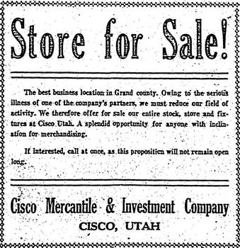
The Pace Brothers Company succeeded the business in 1925[13]. Lynn Sargent Pace(1889 ー 1929) took charge of the Mercantile business.
However, unfortunately, the store burnt to the ground on New Year's Eve the same year[14]. Pace Brothers rebuilt and reopened the store in 1926[15]. This structure, built by White, Okey, and Jones of Montrose survived well into the 70s.
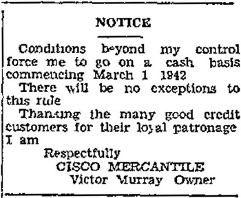
In 1935, Covey Murray(1887 ー 1970) and his brother, State Highway Department foreman, Victor Kirby Murray(1893 ー 1962) bought the property from The Pace Brothers Company with Albert Verne Cain(1905 ー 1982) and started the store and filling station[16].
 : Feb. 19, 1942 Times Independent
 : May 18, 1944 Times Independent
William Richard "Bill"(1889 ー 1971) and Mattie Gertrude Holder(1888 ー 1961) Cowger succeeded the business in 1944[17]. Bill and Mattie later became the “Mom and Pop” of Cisco. The neon signs were put up in 1949[18].
According to the caption added to the 1959 photo by Magnum Photos cameraman Erich Hartmann, “Mom and Pop” ran the motel, bar, restaurant, and a local museum[19]. The bar and matching whiskey cabinet that appears in Hartmann's photo were made by a cabinetmaker, J. C. Poulson, of Denver, CO. in 1848[20].
In 1965, the Mercantile boasted of a bar cafe, a mercantile, a ten-unit motel, and three dwelling houses[21].
In the late 60s, William Woodrow(1918 ー 1984) and Martha M. Walker were the operators of the Mercantile[22]. William's sister-in-law, Helen Lavita Bylerly Walker(1906 ー 1979) acted as the postmistress in 1971; the post office function moved into the Mercantile in 1967[23].
Unfortunately, however, the Annual Financial Statement For the Year Ending Dec. 31, 1971 shows the latest evidence of the survival of the business to this day[24].
According to 1972 Delinquent Tax List, second twin Rillie Nitchie Cowger Beller(1889 ー 1980), Jacob "Jake" Oliver(1907 ー 1991), and Evelyn Boyles succeeded the properties after the demise of Bill Cowger[25]. They put the properties up for final tax sale in 1973[26].
Laurence Walker "Shorty" Hale(1901 ー 1980) of Ethel's Cafe was holding rooster fights in the basement of the closed store, according to Thompson resident AJ Rogers.
1978 Delinquent Tax List has names of Salt Lake City contractor Alexander Louis Jr(1931 ー 1990) and Betty Louise Mast(1934 ー 2008) Quigley as the owner of the property[27].
The structure was entirely destroyed by the fire on June 22, 1979[28].
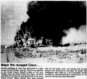 : Jun. 28, 1979 Times Independent
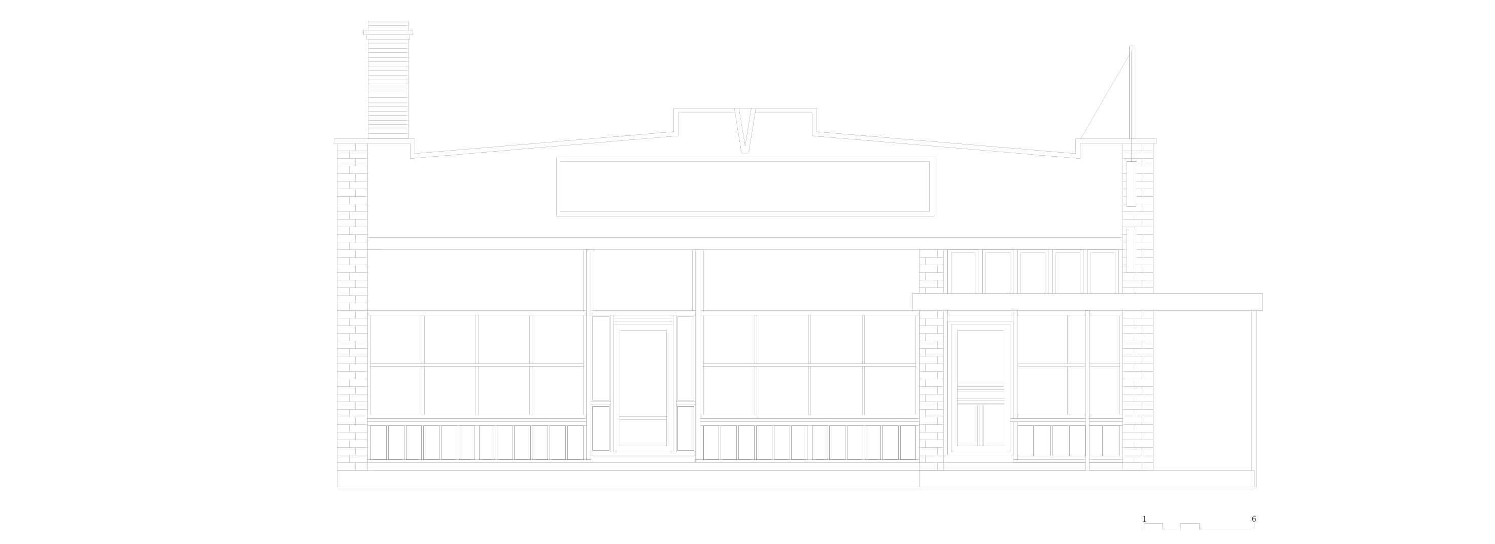
The Mercantile structure built in 1926 featured;
ー"the most modern establishment".
ー"It has a full basement with a heating plant refrigeration system and private electric lighting system".
ー"A massive vault of fireproof construction had also been provided. The building had hardwood floors throughout and the shelving and storage bins follow a style used in the most modern stores throughout the country".
ー"A plate glass front and cement sidewalk added to the attractiveness of the store. The interior of the building was finished in white"[15].
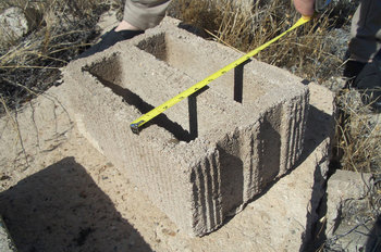
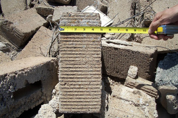
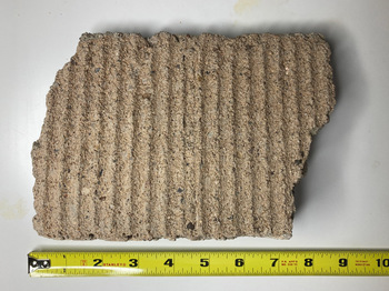
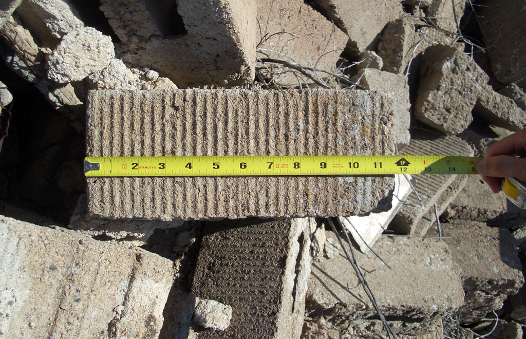
The structure was made of pink-colored concrete blocks called “Pink Brick” with a pin-ribbed surface[29]. Concrete blocks came to produce in the early 1900s in Colorado and Utah[30, 31].
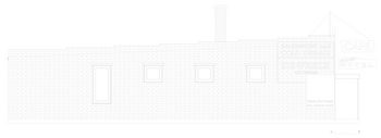
The size of the block seemed nonstandard: the estimated size of the block used here was the 12” x 8” x 5” “Stretcher” type. The 2017 survey confirmed the estimate as shown in the photos below.
I referred to the 1969 aerial photo provided by the U.S. Geological Survey (USGS) to draw the plans. I also counted the block joints in the photos to infer the dimensions. The result is shown below. Of course, some imaginations−especially the interior walls−are included.
 : 12” width, Sep. 10, 2017
 : 8” depth, Sep. 10, 2017
 : 5” height, Sep. 10, 2017
 : texture
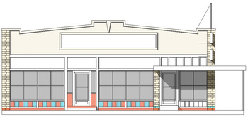 : north elevation
 : west elevation
[1] John Barriger III photo;
[2] Hepperle, Mary L. "Memories of Cisco", Canyon Legacy, vol. 51, Moab Museum, 2004;
[3] Cook, Kenneth L. "Gravity Base Station Network in Utah-1967", Bulletin 92, Utah Geological and Mineralogical Survey, 1971;
[4] Jordan, Kathy. "‘Uranium King’ Charlie Steen started out in Cisco tarpaper shack", Mar. 24, 2011 Daily Sentinel;
[5] Weis, Norman D. Helldorados, Ghosts and Camps of the Old Southwest, Caxton Printers, Ltd. 1977
[6] David photo, flickr;
[7] Dec. 23, 1898, Grand Valley Times;
[8] Aug. 12, 1904 Grand Valley Times;
[9] Jan. 20, 1905 Grand Valley times;
[10] Feb. 21, 1913 Grand Valley Times;
[11] Sep. 6, 1918 Grand Valley Times;
[12] Apr. 18, 1919 Grand Valley Times;
[13] May 21, 1925 Times Independent;
[14] Jan. 7, 1926 Times Independent;
[15] Jun. 24, 1926 Times Independent;
[16] Mar. 7, 1935 Times Independent;
[17] May 11, 1944 Times Independent;
[18] May 10, 1949 Daily Sentinel;
[19] Erich Hartmann photo, Magnum Photos;
[20] Pogue, Mary., Stocks, Verona. "Cisco", Grand Memories, Daughters of Utah Pioneers, 1972
[21] Oct. 1, 1965 Daily Sentinel;
[22] Jul. 27, 1969 Daily Sentinel;
[23] Apr. 29, 1971 Daily Sentinel;
[24] Feb. 25, 1971 Times Independent;
[25] Dec. 28, 1972 Times Independent;
[26] Apr. 26, 1973 Times-Independent;
[27] Dec. 28, 1978 Times Independent;
[28] Jun. 28, 1979 Times Independent;
[29] Jul. 21, 1955 Green River Journal;
[30] Oct. 30, 1905 Salt Lake Mining Review;
[31] May 21, 1904 Daily Sentinel;
 : south elevation, revised
 : west elevation, revised
 : east elevation, revised
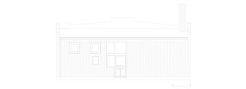 : south elevation, revised
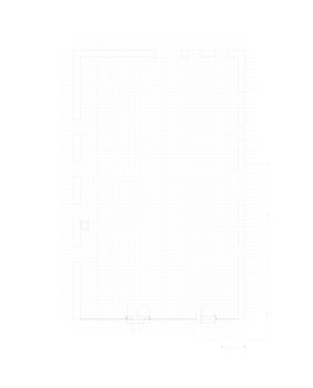 : first floor plan, revised
ユタ州を走るD&RGWの沿線にある/あった、Ciscoという町を紹介している。この建物は「Ruth’s 66 Cafe」の西側に建っていた「Cisco Mercantile」である。Googleのstreet viewで見るように、現在は縁石を残すのみである。
この建物は1926年にPace兄弟によって雑貨店として建てられた。1970年当時は、80歳のCowger氏のものであったはずだ。1959年にマグナムのカメラマンErich Hartmannがここを訪れたときには、Cowger夫妻はレストラン、バー、モーテル、そして博物館を営んでいたという。70年代に廃業し、80年代までに解体されてしまった。
この建物は、映画「Vanishing point」の数シーンに登場する。立面図を制作すべく、例によって目地を数えたところ、ここで使われているのは標準サイズのレンガ・ブロックでないことが分かった。標準サイズのレンガでは、扉の高さが低すぎるのである。色々なレンガ・ブロックの規格に照らしたところ、「Stretcher」型という規格のものがうまく当てはまった。2014年に現地で実測したところ、まさしくこの規格のブロックであることが分かった。
図面は、この規格寸法および1969年撮影の航空写真、映画のスクリーン・キャプチャ画像などを基に描いている。
I’m trying to duplicate the whole town of Cisco, Utah in N scale. This post introduces one of the structures in the town.
A few businesses survived along US Hwy 50 & 6 at Cisco in the early 70s; 4 gas service stations, a mercantile/cafe, and a motel. Some private houses also seem to exist along Second Street. Next to Ruth 66 Cafe on the west sat this structure on Lot 1 to 7 of Block 5, Cisco Townsite.
In the photo by John Barriger III taken no later than 1940, the west and north elevation of the structure are barely seen[1].
In the 1946 photo appeared in Canyon Legacy, a part of the south elevation of the structure is seen[2].
In the 1967 photo appeared in Gravity Base Station Network in Utah, the structure is barely seen[3].
In the 1969 photo appeared in Daily Sentinel, the north and east elevation of the structure are barely seen[4].
In the 1971 movie Vanishing Point, the upraised “Cisco MOTEL”, and “CAFE” neon signs, and the “SANDWICHES and COLD DRINKS” advertisement on the wall are seen.
In the book Helldorados, Ghosts and Camps of the Old Southwest, both the closed storefront and the east elevation of the structure are seen[5].
In the 1978 photo at the Flickr site, the closed storefront of the structure is clearly seen[6].
George Washington Sadler(1864 ー 1921) established a grocery at Cisco in 1898[7]. Moab merchant Hammond & Sons Company also had a branch store managed by Wallace Owen Knight(1879 ー 1958) which burnt to the ground on Aug. 8, 1904[8].
Victor Putman Hanson(1841 ー 1920) established the Cisco Mercantile Company in 1905[9]. Benjamin Harrison(1888 ー 1978) and Owen Leslie(1890 ー 1965) Simpson co-owned the business at least from 1913 to 1918 when they sold it to James Guyn(1879 - 1968) and Douglas Morton(1886 ー 1977) McBride[10, 11, 12]. James was the manager of the Simpsons' business.
: "God’s Country via Automobile, Scenic Transcontinental Route through the Playground of America", 1915, Colorado-Utah Log book Co.
 : Sep. 6, 1918 Grand Valley Times
 : May 22, 1930 Times Independent
The Pace Brothers Company succeeded the business in 1925[13]. Lynn Sargent Pace(1889 ー 1929) took charge of the Mercantile business.
However, unfortunately, the store burnt to the ground on New Year's Eve the same year[14]. Pace Brothers rebuilt and reopened the store in 1926[15]. This structure, built by White, Okey, and Jones of Montrose survived well into the 70s.
In 1935, Covey Murray(1887 ー 1970) and his brother, State Highway Department foreman, Victor Kirby Murray(1893 ー 1962) bought the property from The Pace Brothers Company with Albert Verne Cain(1905 ー 1982) and started the store and filling station[16].
 : Feb. 19, 1942 Times Independent
 : May 18, 1944 Times Independent
William Richard "Bill"(1889 ー 1971) and Mattie Gertrude Holder(1888 ー 1961) Cowger succeeded the business in 1944[17]. Bill and Mattie later became the “Mom and Pop” of Cisco. The neon signs were put up in 1949[18].
According to the caption added to the 1959 photo by Magnum Photos cameraman Erich Hartmann, “Mom and Pop” ran the motel, bar, restaurant, and a local museum[19]. The bar and matching whiskey cabinet that appears in Hartmann's photo were made by a cabinetmaker, J. C. Poulson, of Denver, CO. in 1848[20].
In 1965, the Mercantile boasted of a bar cafe, a mercantile, a ten-unit motel, and three dwelling houses[21].
In the late 60s, William Woodrow(1918 ー 1984) and Martha M. Walker were the operators of the Mercantile[22]. William's sister-in-law, Helen Lavita Bylerly Walker(1906 ー 1979) acted as the postmistress in 1971; the post office function moved into the Mercantile in 1967[23].
Unfortunately, however, the Annual Financial Statement For the Year Ending Dec. 31, 1971 shows the latest evidence of the survival of the business to this day[24].
According to 1972 Delinquent Tax List, second twin Rillie Nitchie Cowger Beller(1889 ー 1980), Jacob "Jake" Oliver(1907 ー 1991), and Evelyn Boyles succeeded the properties after the demise of Bill Cowger[25]. They put the properties up for final tax sale in 1973[26].
Laurence Walker "Shorty" Hale(1901 ー 1980) of Ethel's Cafe was holding rooster fights in the basement of the closed store, according to Thompson resident AJ Rogers.
1978 Delinquent Tax List has names of Salt Lake City contractor Alexander Louis Jr(1931 ー 1990) and Betty Louise Mast(1934 ー 2008) Quigley as the owner of the property[27].
The structure was entirely destroyed by the fire on June 22, 1979[28].
: Jun. 28, 1979 Times IndependentThe Mercantile structure built in 1926 featured;
ー"the most modern establishment".
ー"It has a full basement with a heating plant refrigeration system and private electric lighting system".
ー"A massive vault of fireproof construction had also been provided. The building had hardwood floors throughout and the shelving and storage bins follow a style used in the most modern stores throughout the country".
ー"A plate glass front and cement sidewalk added to the attractiveness of the store. The interior of the building was finished in white"[15].
The structure was made of pink-colored concrete blocks called “Pink Brick” with a pin-ribbed surface[29]. Concrete blocks came to produce in the early 1900s in Colorado and Utah[30, 31].
The size of the block seemed nonstandard: the estimated size of the block used here was the 12” x 8” x 5” “Stretcher” type. The 2017 survey confirmed the estimate as shown in the photos below.
I referred to the 1969 aerial photo provided by the U.S. Geological Survey (USGS) to draw the plans. I also counted the block joints in the photos to infer the dimensions. The result is shown below. Of course, some imaginations−especially the interior walls−are included.
 : 12” width, Sep. 10, 2017
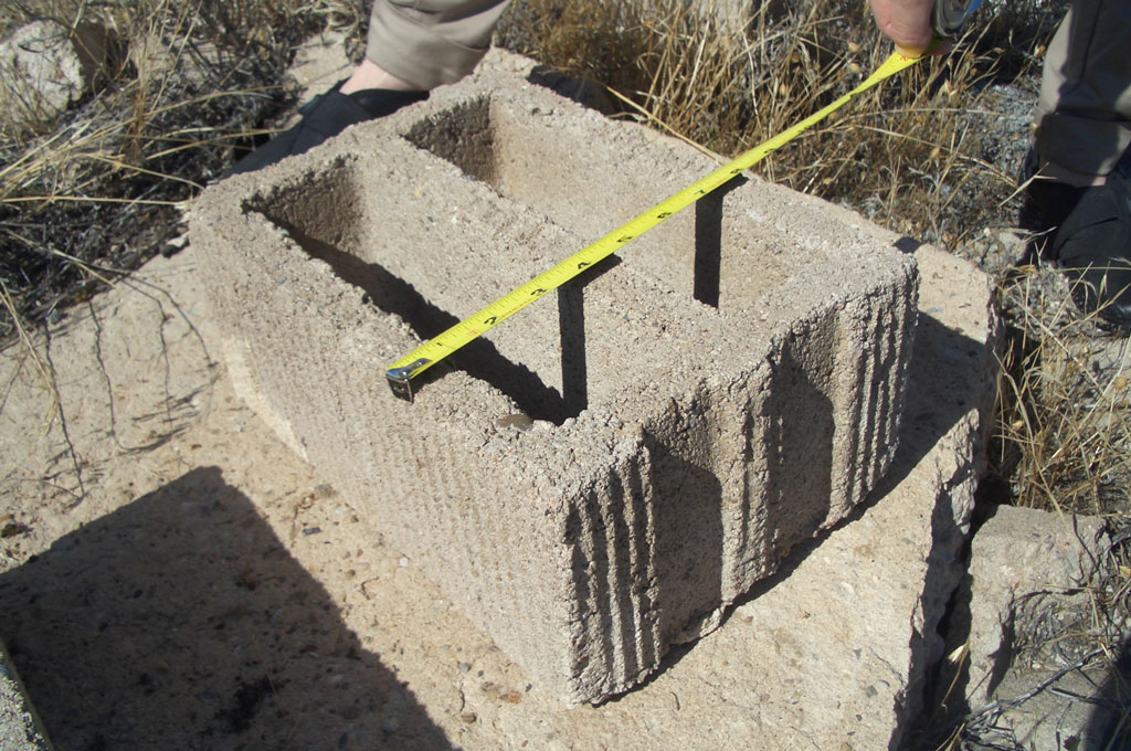 : 8” depth, Sep. 10, 2017
 : 5” height, Sep. 10, 2017
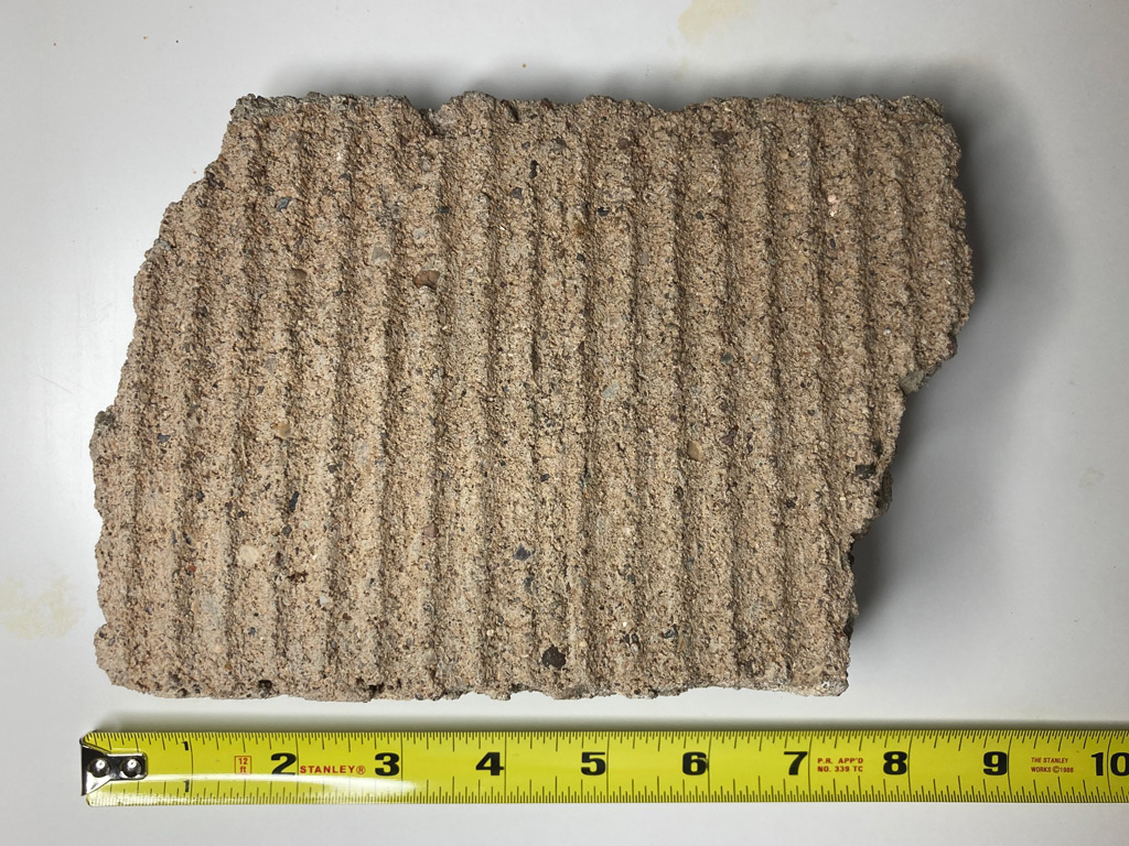 : texture
 : north elevation
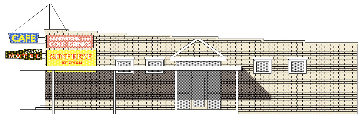 : west elevation
revised Dec. 24, 2013
revised Sep. 22, 2014
revised Jan. 7, 2015
revised Feb. 4, 2015
revised Mar. 2, 2015
revised Oct. 10, 2015
revised Dec. 11, 2015
revised Oct. 23, 2016
revised Dec. 26, 2016
revised Feb. 19, 2018
revised Mar. 8, 2018
revised Nov. 10, 2018
revised Jan. 5, 2020
revised Mar. 2, 2021
revised Jul. 24, 2021
revised Aug. 5, 2021
revised, Sep. 23, 2022
revised, Apr. 14, 2023
[1] John Barriger III photo;
[2] Hepperle, Mary L. "Memories of Cisco", Canyon Legacy, vol. 51, Moab Museum, 2004;
[3] Cook, Kenneth L. "Gravity Base Station Network in Utah-1967", Bulletin 92, Utah Geological and Mineralogical Survey, 1971;
[4] Jordan, Kathy. "‘Uranium King’ Charlie Steen started out in Cisco tarpaper shack", Mar. 24, 2011 Daily Sentinel;
[5] Weis, Norman D. Helldorados, Ghosts and Camps of the Old Southwest, Caxton Printers, Ltd. 1977
[6] David photo, flickr;
[7] Dec. 23, 1898, Grand Valley Times;
[8] Aug. 12, 1904 Grand Valley Times;
[9] Jan. 20, 1905 Grand Valley times;
[10] Feb. 21, 1913 Grand Valley Times;
[11] Sep. 6, 1918 Grand Valley Times;
[12] Apr. 18, 1919 Grand Valley Times;
[13] May 21, 1925 Times Independent;
[14] Jan. 7, 1926 Times Independent;
[15] Jun. 24, 1926 Times Independent;
[16] Mar. 7, 1935 Times Independent;
[17] May 11, 1944 Times Independent;
[18] May 10, 1949 Daily Sentinel;
[19] Erich Hartmann photo, Magnum Photos;
[20] Pogue, Mary., Stocks, Verona. "Cisco", Grand Memories, Daughters of Utah Pioneers, 1972
[21] Oct. 1, 1965 Daily Sentinel;
[22] Jul. 27, 1969 Daily Sentinel;
[23] Apr. 29, 1971 Daily Sentinel;
[24] Feb. 25, 1971 Times Independent;
[25] Dec. 28, 1972 Times Independent;
[26] Apr. 26, 1973 Times-Independent;
[27] Dec. 28, 1978 Times Independent;
[28] Jun. 28, 1979 Times Independent;
[29] Jul. 21, 1955 Green River Journal;
[30] Oct. 30, 1905 Salt Lake Mining Review;
[31] May 21, 1904 Daily Sentinel;
 : south elevation, revised
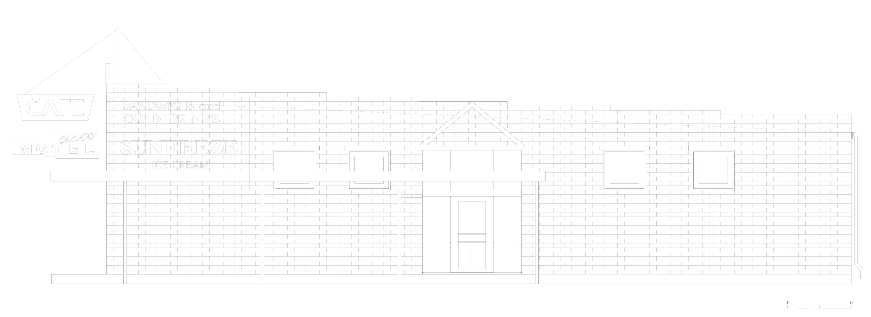 : west elevation, revised
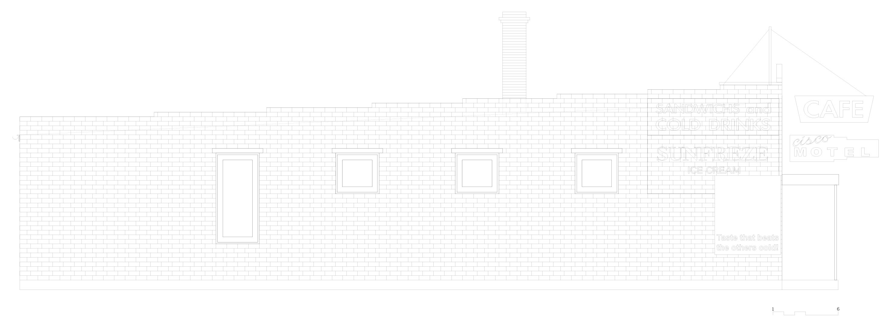 : east elevation, revised
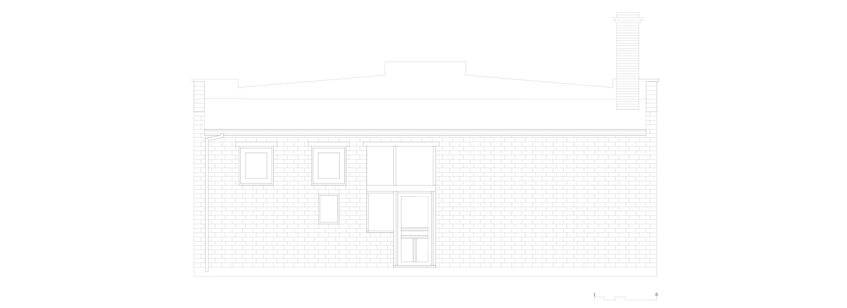 : south elevation, revised
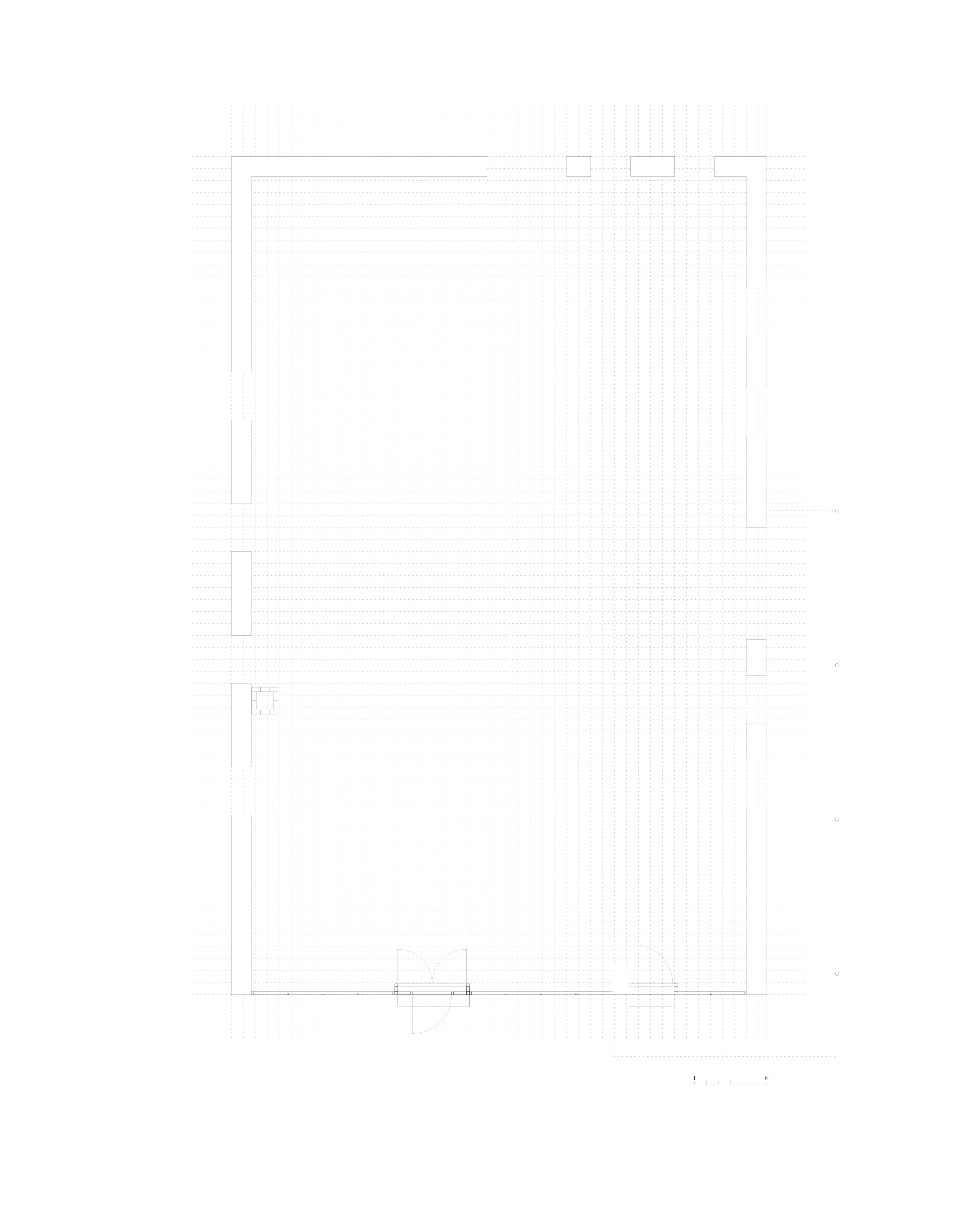 : first floor plan, revised
ユタ州を走るD&RGWの沿線にある/あった、Ciscoという町を紹介している。この建物は「Ruth’s 66 Cafe」の西側に建っていた「Cisco Mercantile」である。Googleのstreet viewで見るように、現在は縁石を残すのみである。
この建物は1926年にPace兄弟によって雑貨店として建てられた。1970年当時は、80歳のCowger氏のものであったはずだ。1959年にマグナムのカメラマンErich Hartmannがここを訪れたときには、Cowger夫妻はレストラン、バー、モーテル、そして博物館を営んでいたという。70年代に廃業し、80年代までに解体されてしまった。
この建物は、映画「Vanishing point」の数シーンに登場する。立面図を制作すべく、例によって目地を数えたところ、ここで使われているのは標準サイズのレンガ・ブロックでないことが分かった。標準サイズのレンガでは、扉の高さが低すぎるのである。色々なレンガ・ブロックの規格に照らしたところ、「Stretcher」型という規格のものがうまく当てはまった。2014年に現地で実測したところ、まさしくこの規格のブロックであることが分かった。
図面は、この規格寸法および1969年撮影の航空写真、映画のスクリーン・キャプチャ画像などを基に描いている。
2013-11-08 09:00
コメント(1)
arx_Ph.D. さん
Here represented are my model railroad enthusiasm generated from the photos I took during my childhood at Knoxville, Tennessee, or from the photos I took during my recent trips.
I'm a retired professor of design, meanwhile a part-time associate at the architectural design office in Osaka, Japan where I live with my wife.


Revised, Dec. 20, 2013
added exterior photo found at 1967 "Gravity Base Station Network in Utah"
by arx_ph.D. (2013-12-24 18:21)