Cisco, Cisco, Cisco, part 18 – Conclusion and appendix [Column_Cisco Township]
I’m trying to build the N scale replica of the town of Cisco, Utah circa 1970. Accordingly, it’s my routine to search “Cisco” on the web, but it goes wrong most of the time bothered by “San Francisco” or “Cisco Systems”. Sometimes, “Cisco, Texas” gets in my way. Thus, I was wondering how many “Cisco”s are there in the United States. My recent research during these Stay Home days revealed some of them. Let me introduce these places named Cisco as a sideshow for my Town of Cisco posts.
We have reviewed 15 communities named Cisco scattered all over the Contiguous United States. Eight of them had Cisco Station/Depot, nine of them had relations with railroads, all the communities had Cisco Post Office, and seven of them were said to be named for a person named Cis/Cisco/Sisco/Francisco.
However, interestingly, I encountered several "Cisco"s beside those communities we have reviewed. Let me introduce some of them:
 : 1950 USGS Aerial Photo showing part of Harrison County, MO
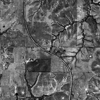
Cisco School, Harrison, Missouri
The Cisco School at Harrison County in Missouri did exist near the Iowa/Missouri border at GPS coordinates 40.52916, -93.90883[1]. The lack of both station and post office caused the place to slip through our dragnet. I could neither find the origin nor the exact place of the community of Cisco. Accordingly, I represent the USGS Aerial Photo showing the former Cisco School site.
1876 Harrison County Map shows "School No. 7" at the corner of the plat owned by Pascal Jennings Richardson(1873 – 1963), which was next to the plat owned by George Francisco(1835 – 1879) on the west[2]. The school might be named for George. 1947 USGS map, Lamoni, IA shows the school as "Cisco Sch".
The one-room school was equipped with a coat room, library, a well for water, and two outhouses. Several families seem inhabited around the school[3]. Mails were carried from Blythedale, four miles south of the school.
Kansas City, St. Joseph & Council Bluffs Railroad built the line from Chariton, IA to St. Joseph, MO. The section through Cisco School was completed in 1880, but trains never stopped here. The line became Chicago Burlington & Quincy in 1901, eventually Burlington Northern in 1970, but was abandoned in 1981.
[1] USGS Feature Detail Report for: Cisco School;
[2] 1876 Harrison County Map;
[3] Fowler, Mildred Irene, Mildred/Mickey Early Childhood;
 : 1955 USGS Aerial Photo showing part of Carter County, OK
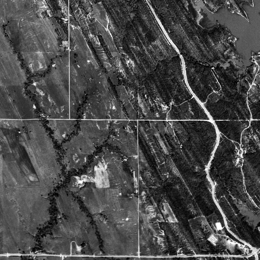
Cisco School, Carter, Oklahoma
Eight out of fifteen "Cisco"s had a "Cisco Road" to reach the namesake community. Accordingly, unconfirmed "Cisco Road" may lead us to the still undiscovered "Cisco".
The Cisco Road found at the south of Ardmore, Oklahoma even had the namesake school along the road: the school was located on the southside of the Cisco Road between Elephant Rock Road and Lake Murray Road[4]. It was at least open between 1906 and 1923[5, 6]. The 1923 photo of the school can be seen on the web[6].
It is said that the schoolhouse became the Lake Murray Inn in the 30s after the closure[4]. But the Inn structure in the photo looks somewhat larger than the particular schoolhouse[7].
However, unfortunately, I could neither find the origin nor the exact place of the community of Cisco. I’m afraid there wasn’t such a community. Or, it may be sunk in the man-made Lake Murray created in 1938. Accordingly, I represent the USGS Aerial Photo showing the Cisco Road and the former Cisco School site.
[4] Jun. 26, 2008 This and That Newsletter, OklahomaHistory.Net;
[5] Nov. 7, 1906 The Daily Admoreite;
[6] Cisco School, District 17, in southeastern Carter County, Oklahoma Historical Society;
[7] Lake Murray Inn among the oaks, OklahomaHistory.Net;
 : 1900 Shelby County Map
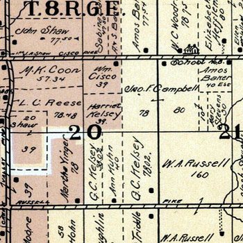
Cisco Road, Shelby, Ohio
Of course, not all the "Cisco Road"s lead us to communities named Cisco. For example, Cisco Road at Shelby County in Ohio never reached a community named Cisco but reached the Francisco homestead.
1875 Turtle Creek Township, Shelby County Map shows the road but without a name. Also is that there was no landowner named Cisco or Francisco.
1900 Turtle Creek Township, Shelby County Map shows the road named "Cisco Pike"[8]. And, William H. Francisco(1841 – 1901) owned a plat and a house on the south side of the namesake road. Likewise, William A. Russell(1837 – 1914) owned plats and a house along the "Russell Pike" ran parallel to "Cisco Pike".
Accordingly, the roads in Turtle Creek Township must have been named for the landowner/inhabitant these days. Both the name of the road survive to this day.
[8] 1900 Turtle Creek Township, Shelby County Map, American Atlas Company;
Cisco Road, Macoupin, Illinois
Another Cisco Road is found at the north of Carlinville crossing the former Gulf Mobile & Ohio Railroad, recently Union Pacific Railroad. The road doesn't lead us to the community of Cisco but to the Central Illinois Steel Company located at 21050 Route 4 Carlinville. The company was founded in 1972 and has a spur diverting from UP main.
Cisco Street, Bakersfield, California
There are even more streets/roads named Cisco, but I believe this Cisco St is one of the shortest in the United States. This dead-end street stretches only about sixty yards according to Google maps. The history of the street seems also relatively short: as far as I researched, it first appears in the 1970 USGS map, Lamont, CA. UP/BNSF, former SP/ATSF industrial spur parallels the street 600 yards to the west.
Cisco, Nantucket, Massachusetts
Cisco, Nantucket, Massachusetts is a beach rather than a community located in Nantucket Island off Cape Cod. Once, the Nantucket Central Railroad served the island but never reached this part of the island. The history of both the name of the places "Cisco" and "Cisco beach" seems relatively short; they first appear in the 1972 USGS map, Nantucket, MA.
Cisco, Garden, Nebraska
The community of Lisco, Garden, Nebraska is erroneously shown with the name "Cisco" in the 2000 United States Census. The exact Lisco, NE is named for the landowner Ruben Lisco(1858 – 1935). Union Pacific line runs through Lisco.
The Google map below shows all the "Cisco"s reviewed in preceding posts.
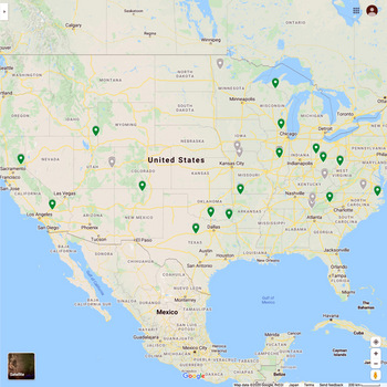 : Google map of Cisco, USA
さしあたり、時刻表や政府要覧をあたり見つけたCiscoを名乗る所在は15ヶ所、その内Cisco駅は8ヶ所、Cisco郵便局は15ヶ所あった。いずれも19世紀後半から20世紀初頭にかけて開設されており、その内7ヶ所における名前の由来は人名(Cisco、Francisco等)であった。
もちろん、これら以外にもCiscoを名乗る所在はあり、全てを網羅した訳ではない。以下、調べる過程で見つけたこれら以外のCiscoについて、落ち穂拾い的に紹介する。
駅や郵便局以上に細かく配置された公的施設に小学校を挙げることができる。多くは既に廃校になっているが、それでも記録には残っていたりする。例えば、ミズーリ州Harrison郡にあったCisco Schoolは、19世紀から70年以上に渡って続いた。もっとも、Ciscoというコミュニティの中心にこの学校が建っていた訳ではなく、貢献者の名前を冠した学校であったようだ。
Ciscoに至る道路の名称をCisco Roadにするのはごく自然である。ところが、オクラホマ州Carter郡に今もあるCisco Roadには、かつてCisco Schoolまであったというから、その先にはCisco村があったと思うのだが、何も見つからない。ひょっとしたら、1938年にできたダム湖に沈んでいるのかも知れない。
全てのCisco Roadの先にCiscoがあった訳ではない事例を挙げる。オハイオ州Shelby郡に今もあるCisco Roadは、1900年発行の地図にもCisco Pikeとして載っている。しかし、その先にCisco村はない。沿道の地主・住民の名前を採って命名したようだ。ネーミング・ライツなどあったのだろうか。
Cisco Roadの先にCiscoがあることもある。といっても、イリノイ州Macoupin郡にあるCisco RoadにあるのはCentral Illinois Steel Companyという鉄工所である。頭文字をつなぐとCISCoになる。
地図にあるCiscoが全て由緒ある地名であるとは限らない。マサチューセッツ州の景勝地ケープ・コッドの近くにあるNantucket島には確かにCiscoという所在があるが、グーグル・ストリートビューで見る限り、海岸砂丘にコテージが点在する海水浴場にすぎない。地形図におけるCiscoの初出は1972年なので、そのころ何らかの意図を持って名付けたのかもしれない。
Ciscoに似た紛らわしい綴りでは、これまでにSiscoやCiskoという綴りを見てきた。いずれも間違いではない。では、Liscoという綴りはどうだろう。ネブラスカ州にあるLiscoという小さな町の名前は、2000年の国勢調査においてCiscoになってしまった。ちなみにこのLiscoという地名の由来も人名である。
以上、これまで見てきたCiscoを冠する所在をグーグルマップにプロットしてみた。幾カ所か集中する所在もあるが、概ねアメリカ本土48州に散在していて、特にこれから読み取れるものはないようだ。
We have reviewed 15 communities named Cisco scattered all over the Contiguous United States. Eight of them had Cisco Station/Depot, nine of them had relations with railroads, all the communities had Cisco Post Office, and seven of them were said to be named for a person named Cis/Cisco/Sisco/Francisco.
However, interestingly, I encountered several "Cisco"s beside those communities we have reviewed. Let me introduce some of them:
 : 1950 USGS Aerial Photo showing part of Harrison County, MO
Cisco School, Harrison, Missouri
The Cisco School at Harrison County in Missouri did exist near the Iowa/Missouri border at GPS coordinates 40.52916, -93.90883[1]. The lack of both station and post office caused the place to slip through our dragnet. I could neither find the origin nor the exact place of the community of Cisco. Accordingly, I represent the USGS Aerial Photo showing the former Cisco School site.
1876 Harrison County Map shows "School No. 7" at the corner of the plat owned by Pascal Jennings Richardson(1873 – 1963), which was next to the plat owned by George Francisco(1835 – 1879) on the west[2]. The school might be named for George. 1947 USGS map, Lamoni, IA shows the school as "Cisco Sch".
The one-room school was equipped with a coat room, library, a well for water, and two outhouses. Several families seem inhabited around the school[3]. Mails were carried from Blythedale, four miles south of the school.
Kansas City, St. Joseph & Council Bluffs Railroad built the line from Chariton, IA to St. Joseph, MO. The section through Cisco School was completed in 1880, but trains never stopped here. The line became Chicago Burlington & Quincy in 1901, eventually Burlington Northern in 1970, but was abandoned in 1981.
[1] USGS Feature Detail Report for: Cisco School;
[2] 1876 Harrison County Map;
[3] Fowler, Mildred Irene, Mildred/Mickey Early Childhood;
 : 1955 USGS Aerial Photo showing part of Carter County, OK
Cisco School, Carter, Oklahoma
Eight out of fifteen "Cisco"s had a "Cisco Road" to reach the namesake community. Accordingly, unconfirmed "Cisco Road" may lead us to the still undiscovered "Cisco".
The Cisco Road found at the south of Ardmore, Oklahoma even had the namesake school along the road: the school was located on the southside of the Cisco Road between Elephant Rock Road and Lake Murray Road[4]. It was at least open between 1906 and 1923[5, 6]. The 1923 photo of the school can be seen on the web[6].
It is said that the schoolhouse became the Lake Murray Inn in the 30s after the closure[4]. But the Inn structure in the photo looks somewhat larger than the particular schoolhouse[7].
However, unfortunately, I could neither find the origin nor the exact place of the community of Cisco. I’m afraid there wasn’t such a community. Or, it may be sunk in the man-made Lake Murray created in 1938. Accordingly, I represent the USGS Aerial Photo showing the Cisco Road and the former Cisco School site.
[4] Jun. 26, 2008 This and That Newsletter, OklahomaHistory.Net;
[5] Nov. 7, 1906 The Daily Admoreite;
[6] Cisco School, District 17, in southeastern Carter County, Oklahoma Historical Society;
[7] Lake Murray Inn among the oaks, OklahomaHistory.Net;
 : 1900 Shelby County Map
Cisco Road, Shelby, Ohio
Of course, not all the "Cisco Road"s lead us to communities named Cisco. For example, Cisco Road at Shelby County in Ohio never reached a community named Cisco but reached the Francisco homestead.
1875 Turtle Creek Township, Shelby County Map shows the road but without a name. Also is that there was no landowner named Cisco or Francisco.
1900 Turtle Creek Township, Shelby County Map shows the road named "Cisco Pike"[8]. And, William H. Francisco(1841 – 1901) owned a plat and a house on the south side of the namesake road. Likewise, William A. Russell(1837 – 1914) owned plats and a house along the "Russell Pike" ran parallel to "Cisco Pike".
Accordingly, the roads in Turtle Creek Township must have been named for the landowner/inhabitant these days. Both the name of the road survive to this day.
[8] 1900 Turtle Creek Township, Shelby County Map, American Atlas Company;
Cisco Road, Macoupin, Illinois
Another Cisco Road is found at the north of Carlinville crossing the former Gulf Mobile & Ohio Railroad, recently Union Pacific Railroad. The road doesn't lead us to the community of Cisco but to the Central Illinois Steel Company located at 21050 Route 4 Carlinville. The company was founded in 1972 and has a spur diverting from UP main.
Cisco Street, Bakersfield, California
There are even more streets/roads named Cisco, but I believe this Cisco St is one of the shortest in the United States. This dead-end street stretches only about sixty yards according to Google maps. The history of the street seems also relatively short: as far as I researched, it first appears in the 1970 USGS map, Lamont, CA. UP/BNSF, former SP/ATSF industrial spur parallels the street 600 yards to the west.
Cisco, Nantucket, Massachusetts
Cisco, Nantucket, Massachusetts is a beach rather than a community located in Nantucket Island off Cape Cod. Once, the Nantucket Central Railroad served the island but never reached this part of the island. The history of both the name of the places "Cisco" and "Cisco beach" seems relatively short; they first appear in the 1972 USGS map, Nantucket, MA.
Cisco, Garden, Nebraska
The community of Lisco, Garden, Nebraska is erroneously shown with the name "Cisco" in the 2000 United States Census. The exact Lisco, NE is named for the landowner Ruben Lisco(1858 – 1935). Union Pacific line runs through Lisco.
The Google map below shows all the "Cisco"s reviewed in preceding posts.
: Google map of Cisco, USAさしあたり、時刻表や政府要覧をあたり見つけたCiscoを名乗る所在は15ヶ所、その内Cisco駅は8ヶ所、Cisco郵便局は15ヶ所あった。いずれも19世紀後半から20世紀初頭にかけて開設されており、その内7ヶ所における名前の由来は人名(Cisco、Francisco等)であった。
もちろん、これら以外にもCiscoを名乗る所在はあり、全てを網羅した訳ではない。以下、調べる過程で見つけたこれら以外のCiscoについて、落ち穂拾い的に紹介する。
◆
駅や郵便局以上に細かく配置された公的施設に小学校を挙げることができる。多くは既に廃校になっているが、それでも記録には残っていたりする。例えば、ミズーリ州Harrison郡にあったCisco Schoolは、19世紀から70年以上に渡って続いた。もっとも、Ciscoというコミュニティの中心にこの学校が建っていた訳ではなく、貢献者の名前を冠した学校であったようだ。
◆
Ciscoに至る道路の名称をCisco Roadにするのはごく自然である。ところが、オクラホマ州Carter郡に今もあるCisco Roadには、かつてCisco Schoolまであったというから、その先にはCisco村があったと思うのだが、何も見つからない。ひょっとしたら、1938年にできたダム湖に沈んでいるのかも知れない。
全てのCisco Roadの先にCiscoがあった訳ではない事例を挙げる。オハイオ州Shelby郡に今もあるCisco Roadは、1900年発行の地図にもCisco Pikeとして載っている。しかし、その先にCisco村はない。沿道の地主・住民の名前を採って命名したようだ。ネーミング・ライツなどあったのだろうか。
Cisco Roadの先にCiscoがあることもある。といっても、イリノイ州Macoupin郡にあるCisco RoadにあるのはCentral Illinois Steel Companyという鉄工所である。頭文字をつなぐとCISCoになる。
◆
地図にあるCiscoが全て由緒ある地名であるとは限らない。マサチューセッツ州の景勝地ケープ・コッドの近くにあるNantucket島には確かにCiscoという所在があるが、グーグル・ストリートビューで見る限り、海岸砂丘にコテージが点在する海水浴場にすぎない。地形図におけるCiscoの初出は1972年なので、そのころ何らかの意図を持って名付けたのかもしれない。
◆
Ciscoに似た紛らわしい綴りでは、これまでにSiscoやCiskoという綴りを見てきた。いずれも間違いではない。では、Liscoという綴りはどうだろう。ネブラスカ州にあるLiscoという小さな町の名前は、2000年の国勢調査においてCiscoになってしまった。ちなみにこのLiscoという地名の由来も人名である。
以上、これまで見てきたCiscoを冠する所在をグーグルマップにプロットしてみた。幾カ所か集中する所在もあるが、概ねアメリカ本土48州に散在していて、特にこれから読み取れるものはないようだ。
2020-12-04 09:00
コメント(0)
arx_Ph.D. さん

Here represented are my model railroad enthusiasm generated from the photos I took during my childhood at Knoxville, Tennessee, or from the photos I took during my recent trips.
I'm a retired professor of design, meanwhile a part-time associate at the architectural design office in Osaka, Japan where I live with my wife.


コメント 0