Flying the Rio Grande Route, part 1 - Colorado [Column_Tracksides]
Google Maps/Earth supply plenty of geographical information though, the real view surpasses them by comprehensibility, especially the relation between topography and the route thru it.
While taking a nice morning flight from Denver to San Francisco, I had a chance to chase after the former Rio Grande route from the sky, as far as Green River, Utah.
Here are some photos I took from the port side cabin window. Click and you can see Rio Grande route and approximate mileposts marked in photos:
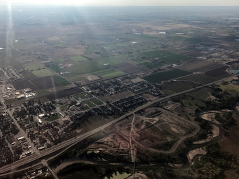 : UP at Fort Lupton
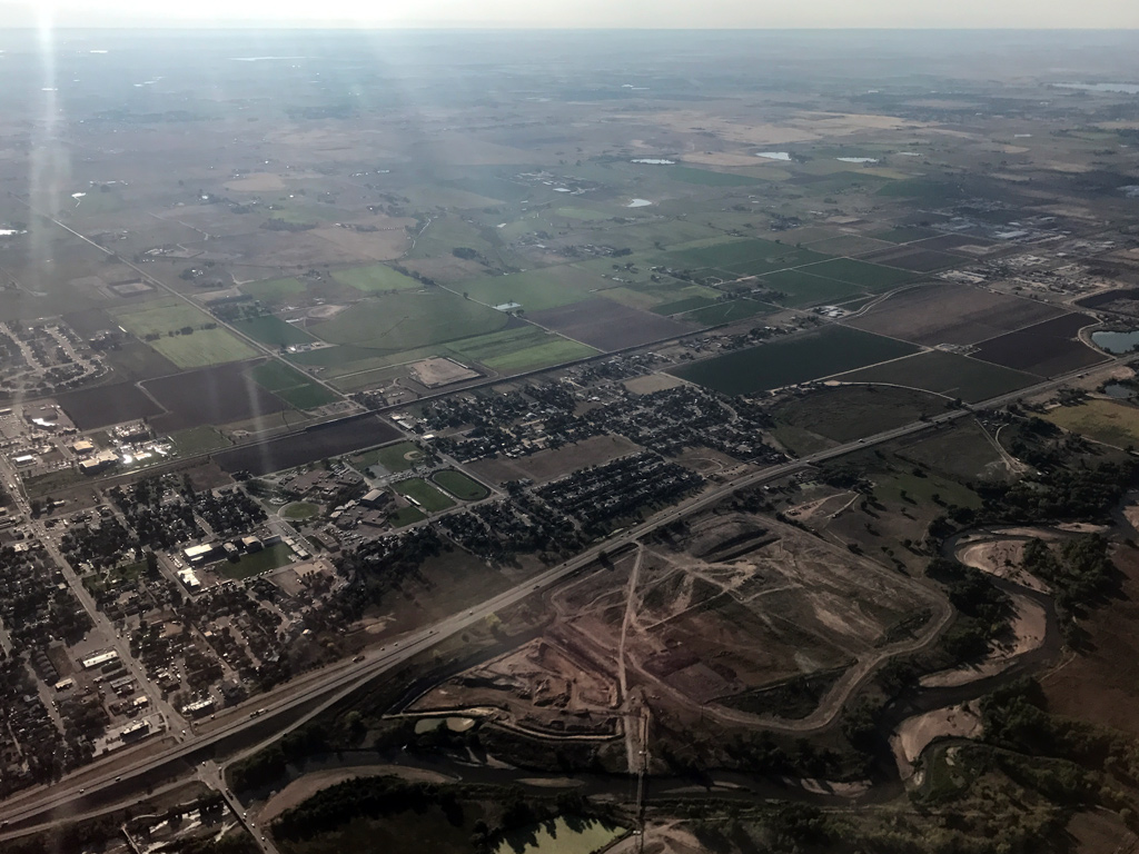
Strictly speaking, this first photo is not the Rio Grande route. Just north of Denver, before level off, I found a moving southbound UP unit auto-rack train with three locomotives on the point at above city of Fort Lupton, Colorado (elev. 4,908'). I just chose this photo to show the relation between railroad track and the flat Great Plains.
 : D&RGW at Rocky
 : arch of the Front Range restored[1]
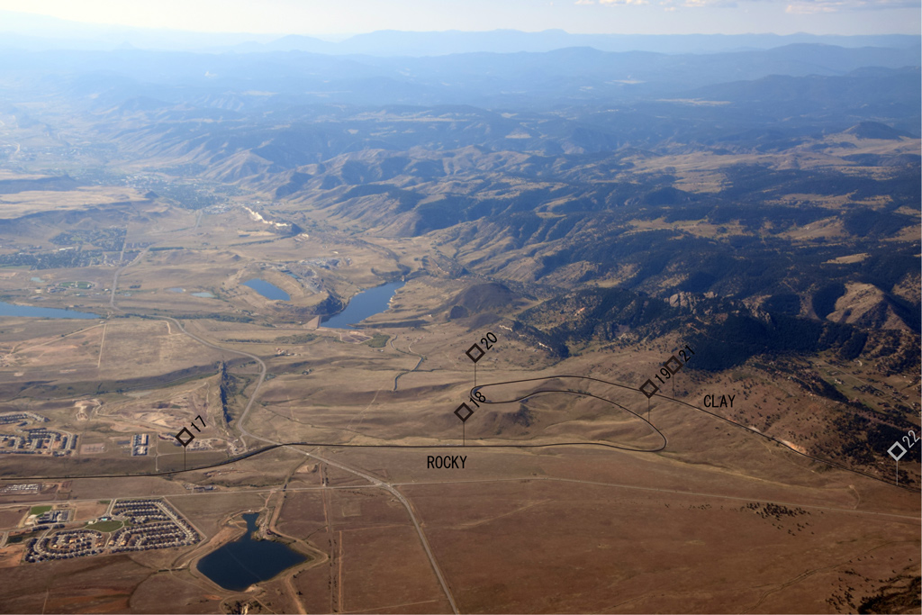
Here, just after turning head west, I found the Big Ten Curve (elev. 6,348' at milepost 20). 2% grade looked tough enough even from the sky. As you can see, the Curve is located at the boundary of Great Plains and the Front Range.
It’s surprising that the wave of housing development is almost reaching the Front Range. Rocky Flats Spur is barely seen at the bottom of the photo.
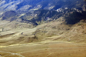 : Big Ten Curve
Here, we see the Curve like a well-made model railroad layout. The photo shows how the curve occupies the unique terrace made of Benton shale[1].
Loaded hopper cars used as windbreak installed in 1971 are clearly seen. The layout of the hopper cars tells us that the wind blows down the slab of Dakota sandstone behind the terrace[1].
I lost sight of the route from west of Tunnel 1 onward.
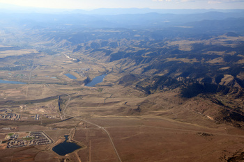
 : D&RGW at Dotsero
 : section across canyon of Colorado River at Shoshone[1]
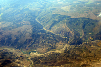
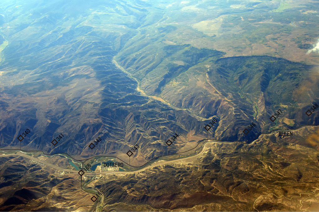
The point I recovered the Rio Grande route was the wye at Dotsero (elev. 6,151'). The river from the left is the Eagle River merging into Colorado River. Upper end of the Glenwood Canyon carving the Park Range can be seen.
The grey flatland opposite the Eagle River near milepost 341 is the lava flow[1].
Finely eroded formation above milepost 342 to 345 is made of Leadville limestone: remember the next depot seven miles east is Gypsum[1]. The route dives into shadow of the canyon westward from this point.
 : D&RGW at Glenwood Springs
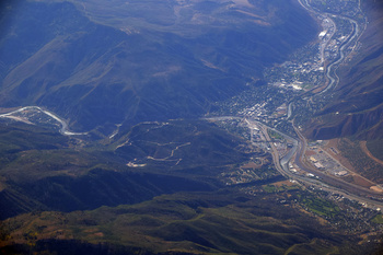
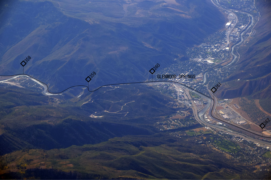
The route came out of the shadow again at Glenwood Springs, Colorado (elev. 5,757'). Namesake hot spring wells up at opposite the depot near milepost 360 across the Colorado River.
The tight meandering of the river and the track near milepost 359 is the result of the move of a fault[2].
The yard west of the town seemed empty. After locating Parachute, the route went away south and I lost sight of the route.
All photos taken on Sep. 12, 2017.
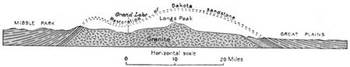
[1] Campbell, Marius R., (1922) Guidebook of the Western United States Part E. The Denver & Rio Grande Western Route, Department of the Interior;
[2] Kirkham, Robert M., (2000) Guide to the Geology of the Glenwood Springs Area, Garfield County, Colorado, Colorado Geological Survey;
筆者は、アメリカ国内線に乗るときはできるだけ窓側に座ることにしている。雲が少なく地上が見えることが多いからだ。今回、デンバーからサンフランシスコへの飛行機では、筆者が愛してやまない旧D&RGWの路線がとてもよく見えた。グーグル・アース等でも地理情報は得られるが、地形と線形の関係の分かり易さなど、やはり実物には代え難い。
テレビ番組ブラタモリの面白さは、人文学的視点も然るものの、自然学特に地学的視点のユニークさにあると思う。地学的視点における、足元の礫が壮大な地殻変動・遠大な時間を証すという、尺度の振れ幅は他に類を見ないものだと思う。そこで今回は、飛行機の窓から撮った写真を元に、D&RGWのルートについて地学的視点を含め紹介しようと思う。
D&RGW沿線の地質学的知見については、ウェブ上に公開されている「Guidebook of the Western United States Part E. The Denver & Rio Grande Western Route」(1922)という資料が、古い本だが、とてもいい案内役になる。料理レシピ本と地質学本に賞味期限はないのではないか。見所について、線路に沿い里程を示し解説するので、ポイントを見つけやすいのが利点だ。
以下、飛行機の窓から撮った写真を元にルートおよび沿線の地形を紹介する。画像は、線形および里程を書き込んだ同画像にリンクしている。
最初の画像はGreat Plains(大平原)を行くUPの列車である。デンバーを離陸して間もないのでまだ高度が低く、肉眼では機関車や貨車の種類までよく見えた。
次に、飛行機が西に旋回するころ見えてきたのが、Big Ten CurveというD&RGW沿線の名所である。線路が、ロッキー山脈を造り出した溶岩隆起によって押し上げられ傾いた、大平原を形成する砂岩層にへばり付く直前にある。この辺りで20‰勾配だというが、もっと急に見えた。残念ながらこれから先、線路は飛行機の右側に行ってしまう。
次に線路を見つけたのは、Dotseroというところである。デンバーからのMoffat Tunnel RouteとプエブロからのTennessee Pass Routeが合流するところである。すぐ右(西)には、これも沿線の名所であるGlenwood Canyonが口を開けている。左(東)隣りの駅はGypsumという。文字通り石灰岩を産出し、石膏ボードの工場がある。同じ石灰岩層の断面が、画像中央の比較的細かい浸食のある斜面である。
Glenwood Canyonを抜けたところにある町がGlenwood Springsである。先のDotseroでは溶岩がコロラド川に流れ込んでいたが、ここではコロラド川を挟んだ駅の向こう(写真手前)岸に温泉が湧く。駅にはAmtrakのCalifornia Zephyrも停車する。コロラド川に合流する支流を遡れば有名リゾート地Aspenである。町を西に抜けたところに小規模なヤードがあるが、何も止まっていないようだ。
While taking a nice morning flight from Denver to San Francisco, I had a chance to chase after the former Rio Grande route from the sky, as far as Green River, Utah.
Here are some photos I took from the port side cabin window. Click and you can see Rio Grande route and approximate mileposts marked in photos:
 : UP at Fort Lupton
Strictly speaking, this first photo is not the Rio Grande route. Just north of Denver, before level off, I found a moving southbound UP unit auto-rack train with three locomotives on the point at above city of Fort Lupton, Colorado (elev. 4,908'). I just chose this photo to show the relation between railroad track and the flat Great Plains.
 : D&RGW at Rocky
 : arch of the Front Range restored[1]
Here, just after turning head west, I found the Big Ten Curve (elev. 6,348' at milepost 20). 2% grade looked tough enough even from the sky. As you can see, the Curve is located at the boundary of Great Plains and the Front Range.
It’s surprising that the wave of housing development is almost reaching the Front Range. Rocky Flats Spur is barely seen at the bottom of the photo.
 : Big Ten Curve
Here, we see the Curve like a well-made model railroad layout. The photo shows how the curve occupies the unique terrace made of Benton shale[1].
Loaded hopper cars used as windbreak installed in 1971 are clearly seen. The layout of the hopper cars tells us that the wind blows down the slab of Dakota sandstone behind the terrace[1].
I lost sight of the route from west of Tunnel 1 onward.
 : D&RGW at Dotsero
 : section across canyon of Colorado River at Shoshone[1]
The point I recovered the Rio Grande route was the wye at Dotsero (elev. 6,151'). The river from the left is the Eagle River merging into Colorado River. Upper end of the Glenwood Canyon carving the Park Range can be seen.
The grey flatland opposite the Eagle River near milepost 341 is the lava flow[1].
Finely eroded formation above milepost 342 to 345 is made of Leadville limestone: remember the next depot seven miles east is Gypsum[1]. The route dives into shadow of the canyon westward from this point.
 : D&RGW at Glenwood Springs
The route came out of the shadow again at Glenwood Springs, Colorado (elev. 5,757'). Namesake hot spring wells up at opposite the depot near milepost 360 across the Colorado River.
The tight meandering of the river and the track near milepost 359 is the result of the move of a fault[2].
The yard west of the town seemed empty. After locating Parachute, the route went away south and I lost sight of the route.
All photos taken on Sep. 12, 2017.
[1] Campbell, Marius R., (1922) Guidebook of the Western United States Part E. The Denver & Rio Grande Western Route, Department of the Interior;
[2] Kirkham, Robert M., (2000) Guide to the Geology of the Glenwood Springs Area, Garfield County, Colorado, Colorado Geological Survey;
筆者は、アメリカ国内線に乗るときはできるだけ窓側に座ることにしている。雲が少なく地上が見えることが多いからだ。今回、デンバーからサンフランシスコへの飛行機では、筆者が愛してやまない旧D&RGWの路線がとてもよく見えた。グーグル・アース等でも地理情報は得られるが、地形と線形の関係の分かり易さなど、やはり実物には代え難い。
テレビ番組ブラタモリの面白さは、人文学的視点も然るものの、自然学特に地学的視点のユニークさにあると思う。地学的視点における、足元の礫が壮大な地殻変動・遠大な時間を証すという、尺度の振れ幅は他に類を見ないものだと思う。そこで今回は、飛行機の窓から撮った写真を元に、D&RGWのルートについて地学的視点を含め紹介しようと思う。
D&RGW沿線の地質学的知見については、ウェブ上に公開されている「Guidebook of the Western United States Part E. The Denver & Rio Grande Western Route」(1922)という資料が、古い本だが、とてもいい案内役になる。料理レシピ本と地質学本に賞味期限はないのではないか。見所について、線路に沿い里程を示し解説するので、ポイントを見つけやすいのが利点だ。
以下、飛行機の窓から撮った写真を元にルートおよび沿線の地形を紹介する。画像は、線形および里程を書き込んだ同画像にリンクしている。
◆
最初の画像はGreat Plains(大平原)を行くUPの列車である。デンバーを離陸して間もないのでまだ高度が低く、肉眼では機関車や貨車の種類までよく見えた。
◆
次に、飛行機が西に旋回するころ見えてきたのが、Big Ten CurveというD&RGW沿線の名所である。線路が、ロッキー山脈を造り出した溶岩隆起によって押し上げられ傾いた、大平原を形成する砂岩層にへばり付く直前にある。この辺りで20‰勾配だというが、もっと急に見えた。残念ながらこれから先、線路は飛行機の右側に行ってしまう。
◆
次に線路を見つけたのは、Dotseroというところである。デンバーからのMoffat Tunnel RouteとプエブロからのTennessee Pass Routeが合流するところである。すぐ右(西)には、これも沿線の名所であるGlenwood Canyonが口を開けている。左(東)隣りの駅はGypsumという。文字通り石灰岩を産出し、石膏ボードの工場がある。同じ石灰岩層の断面が、画像中央の比較的細かい浸食のある斜面である。
◆
Glenwood Canyonを抜けたところにある町がGlenwood Springsである。先のDotseroでは溶岩がコロラド川に流れ込んでいたが、ここではコロラド川を挟んだ駅の向こう(写真手前)岸に温泉が湧く。駅にはAmtrakのCalifornia Zephyrも停車する。コロラド川に合流する支流を遡れば有名リゾート地Aspenである。町を西に抜けたところに小規模なヤードがあるが、何も止まっていないようだ。
2018-01-12 09:00
コメント(0)
arx_Ph.D. さん

Here represented are my model railroad enthusiasm generated from the photos I took during my childhood at Knoxville, Tennessee, or from the photos I took during my recent trips.
I'm a retired professor of design, meanwhile a part-time associate at the architectural design office in Osaka, Japan where I live with my wife.


コメント 0