Flying the Rio Grande Route, part 2 - Utah [Column_Tracksides]
Google Maps supplies plenty of geographical information though, the real look surpasses it by comprehensibility, especially the relationship between topography and the route thru it.
While taking a nice morning flight from Denver to San Francisco, I had a chance to chase after the former Rio Grande route from the sky, as far as Green River, Utah.
Here are some photos I took from the port side cabin window. Click and you can see Rio Grande route and approximate mileposts marked in photos:
 : D&RGW at Mack
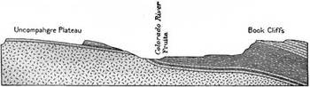 : section across the valley at Fruita[1]
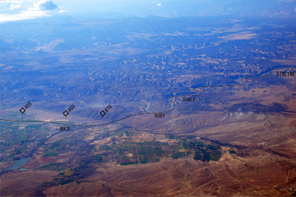
I recovered the former Rio Grande route at the west end of Grand Valley at Mack, Colorado (elev. 4,533'). Here, the route begins tagging into Ruby Canyon where Colorado River carves Uncompahgre Plateau.
The old narrow gauge Rio Grande route and the Uintah Railway used to follow Salt Creek on Mancos shale west of Mack[1].
 : D&RGW at Cisco
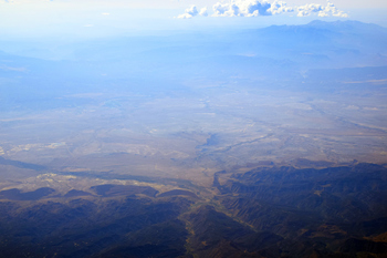
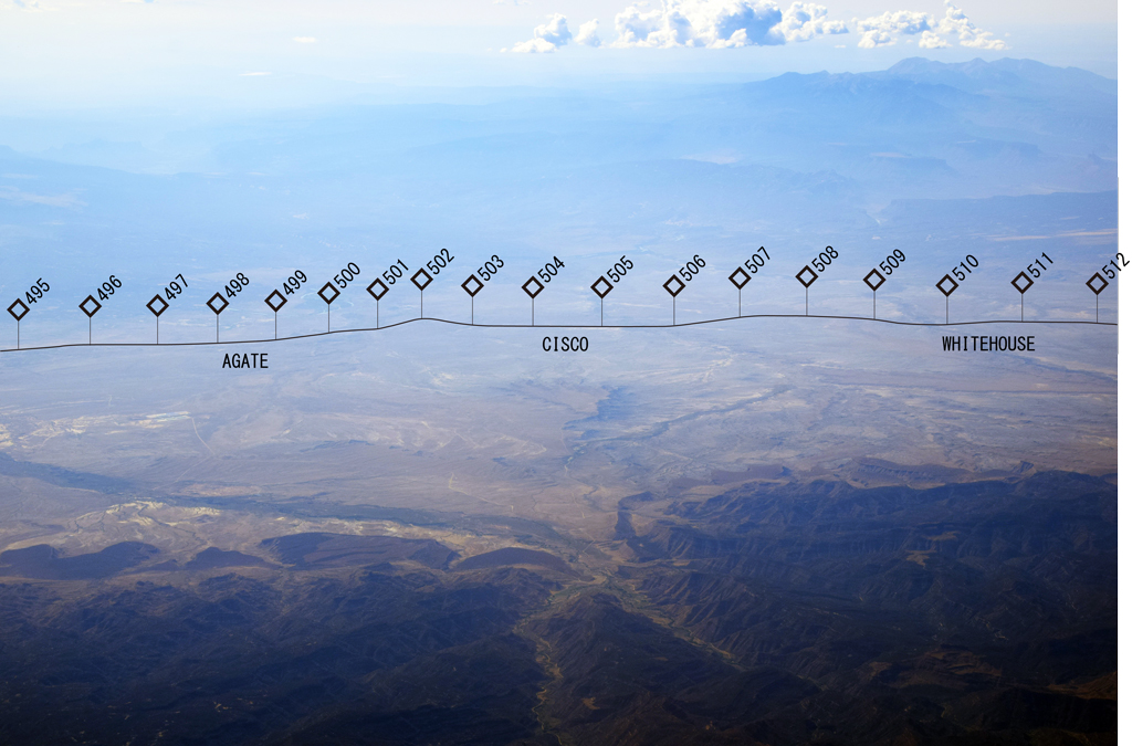
After diverting Colorado River at Westwater, Utah (elev. 4,316'), the route follows the edge of fans made on McElmo formation (milepost 501 east) and Mancos shale (milepost 501 west) by several washes (from left to right: Danish, Cisco and Nash)[1].
The area is an oil & gas field called Greater Cisco Field including Harley Dome, Seiber Nose, Sage, Agate, Gravel, Cisco Townsite, Cisco Wash and Cisco Dome Field.
Dark mass in the foreground is the Book Cliffs covered by Mesaverde formation and the mass far right with clouds is the La Sal Mountains. Colorado River shows its bend at east of town of Cisco, Utah (elev. 4,370').
 : D&RGW at Thompson
 : Book Cliffs and the town of Thompson
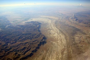
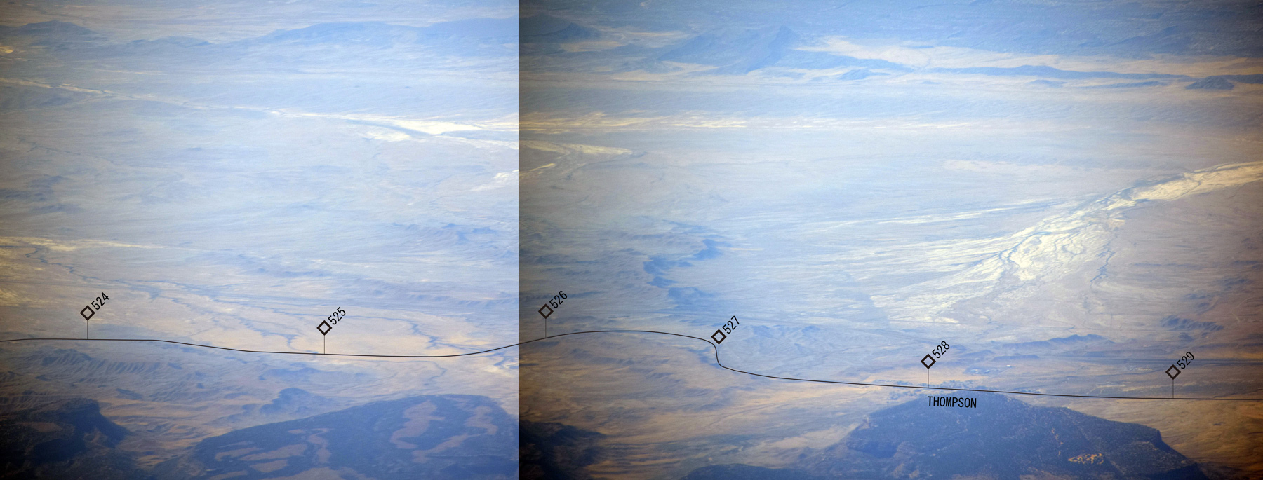
Here is the aerial view of Thompson Hill (aka Thompson Cut, elev. 5,080' at milepost 526) and the town of Thompson, Utah (elev. 5,127').
As you can see, the Hill is located at the tip of the shale ridge eroded by both Salt Wash and Thompson Wash. Little round stones underfoot proved the shale was formed underwater.
 : D&RGW at Desert
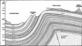 : section across San Rafael Swell[2]
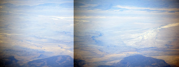
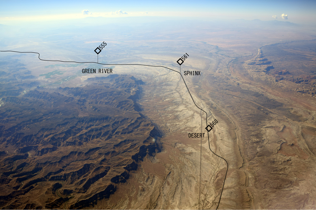
Finally, the Rio Grande route meets San Rafael Swell and turns north to Soldier Summit (elev. 7,440') on Wasatch Mountains.
Vegetated area in the middle of Gunnison Valley at the left is the city of Green River, Utah (elev. 4,066'), the lowest point of the entire Rio Grande route. Woodside (elev. 4,635') is beneath my feet. Far right under the cloud is the Henry Mountains.
The joy of chasing after Rio Grande route thru the Rockies lasted nearly an hour. One more topic I should add to this two and a half hours flight route may be the Half Dome at Yosemite National Park appears at last twenty minutes: It flies right above of it. Or, how about the Infinite Loop of Apple? The diameter of both of them looks almost the same to me in Google Maps!
All photos were taken on Sep. 12, 2017.
[1] Campbell, Marius R., (1922) Guidebook of the Western United States Part E. The Denver & Rio Grande Western Route, Department of the Interior;
[2] Share, Jack (2011) "Flight Plan: Part I – Geology of the San Rafael Swell", Written in Stone;
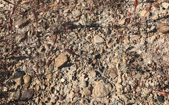 : surface of Mancos shale with dried Desert Trumpet at Thompson
前回の続きである。以下、窓から撮った写真を元にルートおよび沿線の地形を紹介する。空撮画像は、線形および里程を書き込んだ同画像にリンクしている。
Grand Valleyと呼ばれるグランド・ジャンクションがある谷の西端はユタ州に連なる砂漠地帯になっている。この辺りまでをロッキー山脈の「Western Slope」と称するようだ。D&RGWの線路は、ここから平らな人里を離れて、蛇行するコロラド川沿いの景勝地であるRuby Canyonを経てユタ州に至る。
ユタ州に入ると線路はコロラド川から離れ、砂漠の中を、Book Cliffsから流れ出るいくつかの沢が造り出した扇状地の裾を縫うように、勾配を避けながら西進する。この辺りの扇状地ではかつて天然ガスや原油を産出していた。大きく南に流れを変えるコロラド川がかろうじて見える。
次は、先に紹介した鉄道写真の名所「Thompson Hill」を空から見たところである。二本の沢に挟まれ浸食されたシェール層が岬のように突きだし、線路がその先をかすめるように迂回する様がよく分かる。この辺りの地表を覆うシェール層には、河原にあるような丸みを帯びた小石が多く混ざっていた。
Green RiverはD&RGW沿線の標高における最低地点である。オアシスのように、砂漠の真ん中でここだけ緑を茂らせている。ここから先線路は北に伸び、飛行機の視界からは消える。
ここまでデンバーから一時間弱、とても楽しめた。サンフランシスコまでは二時間半だが、このルートには終わり近くにもうひとつ楽しみが待っている。ヨセミテ国立公園である。飛行機はHalf Domeのほぼ真上を飛ぶ。あるいはSan Jose郊外にできたAppleの新社屋「Infinite Loop」を名所に入れてもいいかもしれない。両者はGoogle Mapsではおおよそ同じ直径に見える。
While taking a nice morning flight from Denver to San Francisco, I had a chance to chase after the former Rio Grande route from the sky, as far as Green River, Utah.
Here are some photos I took from the port side cabin window. Click and you can see Rio Grande route and approximate mileposts marked in photos:
 : D&RGW at Mack
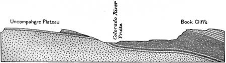 : section across the valley at Fruita[1]
I recovered the former Rio Grande route at the west end of Grand Valley at Mack, Colorado (elev. 4,533'). Here, the route begins tagging into Ruby Canyon where Colorado River carves Uncompahgre Plateau.
The old narrow gauge Rio Grande route and the Uintah Railway used to follow Salt Creek on Mancos shale west of Mack[1].
 : D&RGW at Cisco
After diverting Colorado River at Westwater, Utah (elev. 4,316'), the route follows the edge of fans made on McElmo formation (milepost 501 east) and Mancos shale (milepost 501 west) by several washes (from left to right: Danish, Cisco and Nash)[1].
The area is an oil & gas field called Greater Cisco Field including Harley Dome, Seiber Nose, Sage, Agate, Gravel, Cisco Townsite, Cisco Wash and Cisco Dome Field.
Dark mass in the foreground is the Book Cliffs covered by Mesaverde formation and the mass far right with clouds is the La Sal Mountains. Colorado River shows its bend at east of town of Cisco, Utah (elev. 4,370').
 : D&RGW at Thompson
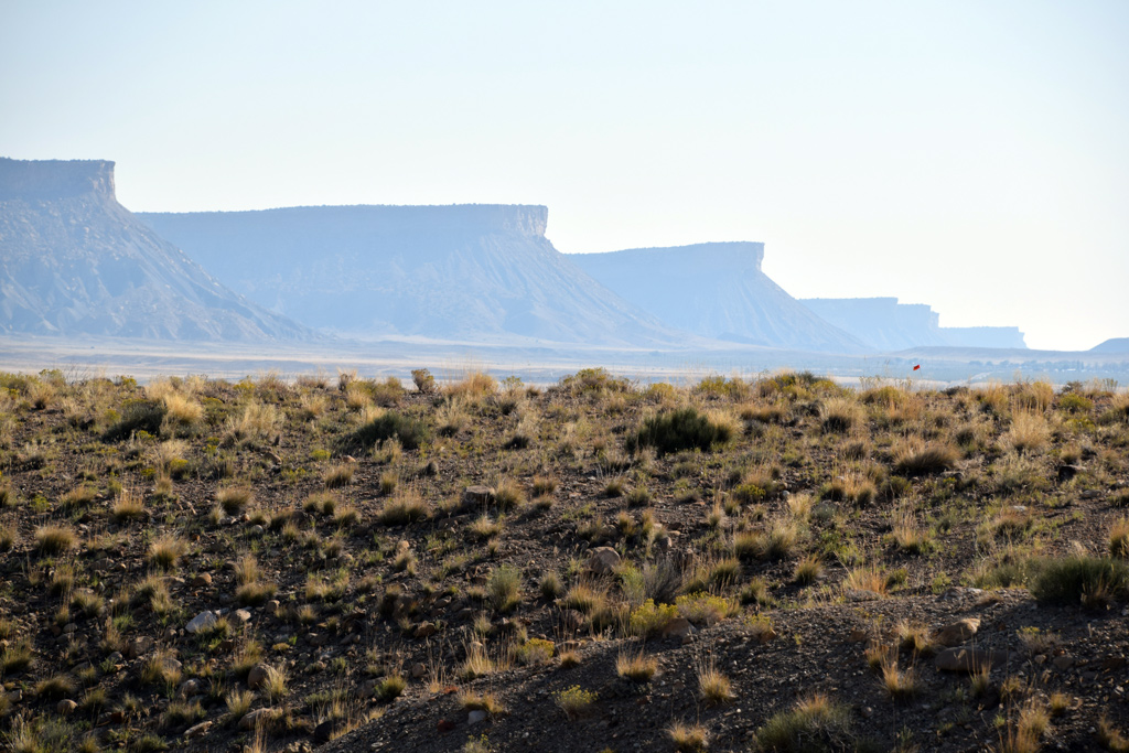 : Book Cliffs and the town of Thompson
Here is the aerial view of Thompson Hill (aka Thompson Cut, elev. 5,080' at milepost 526) and the town of Thompson, Utah (elev. 5,127').
As you can see, the Hill is located at the tip of the shale ridge eroded by both Salt Wash and Thompson Wash. Little round stones underfoot proved the shale was formed underwater.
 : D&RGW at Desert
 : section across San Rafael Swell[2]
Finally, the Rio Grande route meets San Rafael Swell and turns north to Soldier Summit (elev. 7,440') on Wasatch Mountains.
Vegetated area in the middle of Gunnison Valley at the left is the city of Green River, Utah (elev. 4,066'), the lowest point of the entire Rio Grande route. Woodside (elev. 4,635') is beneath my feet. Far right under the cloud is the Henry Mountains.
The joy of chasing after Rio Grande route thru the Rockies lasted nearly an hour. One more topic I should add to this two and a half hours flight route may be the Half Dome at Yosemite National Park appears at last twenty minutes: It flies right above of it. Or, how about the Infinite Loop of Apple? The diameter of both of them looks almost the same to me in Google Maps!
All photos were taken on Sep. 12, 2017.
revised, Feb 1, 2020
[1] Campbell, Marius R., (1922) Guidebook of the Western United States Part E. The Denver & Rio Grande Western Route, Department of the Interior;
[2] Share, Jack (2011) "Flight Plan: Part I – Geology of the San Rafael Swell", Written in Stone;
 : surface of Mancos shale with dried Desert Trumpet at Thompson
前回の続きである。以下、窓から撮った写真を元にルートおよび沿線の地形を紹介する。空撮画像は、線形および里程を書き込んだ同画像にリンクしている。
◆
Grand Valleyと呼ばれるグランド・ジャンクションがある谷の西端はユタ州に連なる砂漠地帯になっている。この辺りまでをロッキー山脈の「Western Slope」と称するようだ。D&RGWの線路は、ここから平らな人里を離れて、蛇行するコロラド川沿いの景勝地であるRuby Canyonを経てユタ州に至る。
◆
ユタ州に入ると線路はコロラド川から離れ、砂漠の中を、Book Cliffsから流れ出るいくつかの沢が造り出した扇状地の裾を縫うように、勾配を避けながら西進する。この辺りの扇状地ではかつて天然ガスや原油を産出していた。大きく南に流れを変えるコロラド川がかろうじて見える。
◆
次は、先に紹介した鉄道写真の名所「Thompson Hill」を空から見たところである。二本の沢に挟まれ浸食されたシェール層が岬のように突きだし、線路がその先をかすめるように迂回する様がよく分かる。この辺りの地表を覆うシェール層には、河原にあるような丸みを帯びた小石が多く混ざっていた。
◆
Green RiverはD&RGW沿線の標高における最低地点である。オアシスのように、砂漠の真ん中でここだけ緑を茂らせている。ここから先線路は北に伸び、飛行機の視界からは消える。
ここまでデンバーから一時間弱、とても楽しめた。サンフランシスコまでは二時間半だが、このルートには終わり近くにもうひとつ楽しみが待っている。ヨセミテ国立公園である。飛行機はHalf Domeのほぼ真上を飛ぶ。あるいはSan Jose郊外にできたAppleの新社屋「Infinite Loop」を名所に入れてもいいかもしれない。両者はGoogle Mapsではおおよそ同じ直径に見える。
2018-01-19 09:00
コメント(0)
arx_Ph.D. さん
Here represented are my model railroad enthusiasm generated from the photos I took during my childhood at Knoxville, Tennessee, or from the photos I took during my recent trips.
I'm a retired professor of design, meanwhile a part-time associate at the architectural design office in Osaka, Japan where I live with my wife.


コメント 0